Southwest Michigan residents may soon see low-flying helicopters carrying strange equipment.

They’re taking to the sky over 16 counties to map geology and aquifers.
The work is part of a study between the U.S. Geological Survey and the Michigan Department of Environment, Great Lakes, and Energy to enhance the understanding and protection of Michigan’s vast groundwater reserves.
Survey flights starting this month will continue through the summer over all or part of Allegan, Barry, Berrien, Branch, Calhoun, Cass, Eaton, Hillsdale, Ingham, Ionia, Jackson, Kalamazoo, Kent, Ottawa, St. Joseph, and Van Buren counties.
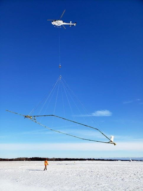
According to EGLE, the helicopters will fly at about 200 feet and will suspend a large hoop-like horizontal frame on a cable about 100 feet below the aircraft carrying instruments to measure differences in Earth’s electrical properties and magnetic field created by different rock types.
“The daylight-only flights completed by specially trained pilots will avoid densely populated areas and will not pass over buildings at low altitude,” EGLE said in an announcement. “The work poses no risk to humans, animals, or plant life and does not collect photos or videos.”
The cooperative study is expected to provide a better understanding of bedrock depth and give additional data about aquifer systems in southwest Michigan, allowing for better informed decisions about managing groundwater resources.
“The 3-D models and maps are important for improving our understanding of water resources,” said Burke Minsley, the USGS research geophysicist in charge of the airborne survey. “This type of airborne survey allows us to cover large areas very effectively.”
Southwest Michigan was selected due to the number of large-quantity water withdrawals, fast population growth, and groundwater availability issues that have been identified in that part of the state.
Local officials and conservation contacts will be informed of the activities. A flight tracker will map the daily progress of the study.
This article originally appeared on Sturgis Journal: Low flying helicopters will map Michigan’s groundwater
Reporting by Liz Shepard, Sturgis Journal / Sturgis Journal
USA TODAY Network via Reuters Connect