Flood warnings, watches and advisories have been issued across a wide area of northern Michigan as rivers and streams surge higher amid snowmelt and continuing rain, the National Weather Service said on April 14.
The entire Upper Peninsula and the northern Lower Peninsula remain under a flood watch. Flash flood and flood warnings and advisories have been issued near several dams, including the Cheboygan, Tippy and Mio, in the northern Lower Peninsula.

Some of the heaviest flooding has been reported along the Au Sable River near Red Oak, located in the northeast Lower Peninsula; the Manistee River, near Sherman in the northwest Lower Peninsula; and the Muskegon River at Evart, according to the NOAA Water Prediction Service map.
A flood warning was issued by the National Weather Service in Gaylord at 6:12 a.m. on Tuesday, April 14, for Cheboygan and Emmet counties.
“This is a prolonged flooding event in the affected areas. Be prepared for impacts from high water to last through the week, and potentially longer. Ice on area lakes will slow the flow of water and may prolong the timeframe of this event. Please report observed flooding to local emergency services or law enforcement and request they pass this information to the National Weather Service when you can do so safely,” the NWS said.
While the Cheboygan and Bellaire dams are being monitored for potential failure because of high water behind them, which could cause downstream flooding, the warning in Emmet and Cheboygan counties is for the Cheboygan River basin upstream of the dam, the NWS said, including the Maple River, Crooked Lake, Crooked River, Burt Lake, Indian River, Mullet Lake, Black Lake, the Black River, and the Sturgeon River.
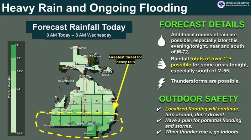
Another round of thunderstorms is forecast to develop Tuesday night, April 14, that could increase flood dangers further.
“A brief dry spell today will give way to a fresh round of storms tonight (April 14),” Detroit NWS said on X on April 14. “Localized flooding remains a concern, especially in urban and low-lying areas.”
Up to 1.8 inches of rain is expected by Wednesday afternoon, April 15, with the heaviest in the southern Lower Peninsula around the Grand Rapids area, according to the NWS Probabilistic Precipitation Portal.
“Additional rain on top of recent heavy rainfall and snow melt has lead to flooding across much of northern Michigan. Flows in rivers will continue to increase and may reach critical levels,” the NWS said in a hazardous weather outlook.
In addition to flooding, an isolated tornado, large hail and strong winds are potential threats.
“All hazards are on the table, depending on how far north the front stays today (April 14). Best shot at heavy rain will be south of M-72, and esp(ecially) near M-55. Stay tuned,” Gaylord National Weather Service posted on X on April 14.
Officials urge residents to stay weather aware and to have multiple ways of receiving weather alert at all hours.
Here’s where rivers stand in Michigan as of Monday, April 14, and the live radar.
Flash flood warnings extended for northern Michigan
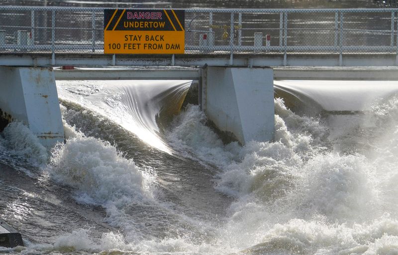
Two dams in the northeast Lower Peninsula are being watched because of high water and flash flood warnings have been issued. Officials said the dams are releasing high volumes of water and may cause flooding downstream.
Officials have extended flash flood warnings where cities are at risk for flash flooding, according to the NOAA Water Prediction Service map:
If you are in low areas below the Tippy or Mio dams, officials say you should move to higher ground immediately, and to not drive across flooded streets.
What’s happening in Cheboygan?
On Tuesday, April 14, the Cheboygan River continued rising, inching closer to the top of the Cheboygan Lock & Dam Complex, which officials fear may fail and cause flooding downstream.
The rising waters have local residents on standby to evacuate as the water level is 7.68 inches below the top of the structure, according to the 7 a.m. Tuesday, April 14 update. That’s an increase of about 6 inches from the water levels on Monday, April 13.
Where are flood warnings in effect?
Flood warnings in effect in Michigan as of April 14 include:
Where are flood advisories in place?
Advisories continue for rivers in these counties as of April 14:
Where is it raining? Michigan live Doppler radar
Where are current flood warnings, advisories and watches?
To view the details of a warning, watch or advisory in Michigan click on any shaded region shown on the map.
The bright green shading indicates flood warnings, while the red lines indicate a flash flood warning.
— The Detroit Free Press contributed
Contact Sarah Moore @ smoore@lsj.com
This article originally appeared on Lansing State Journal: Flood warnings, advisories extended in northern Michigan. See where
Reporting by Sarah Moore, Lansing State Journal / Lansing State Journal
USA TODAY Network via Reuters Connect