
Officials say residents in Michigan’s Lower and Upper peninsulas are facing extreme wildfire risk Thursday, June 4, as warm weather continues across the state.
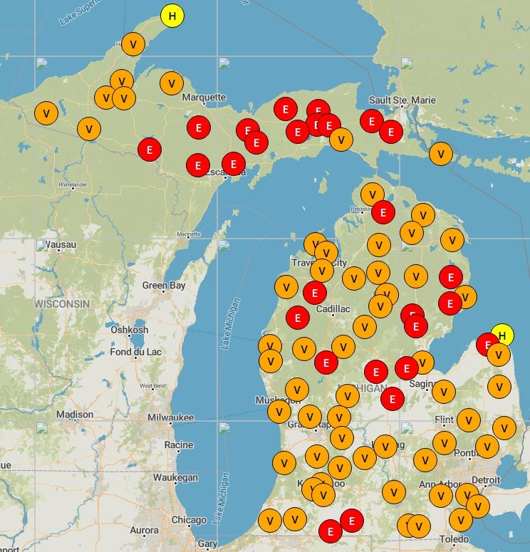
Wildfires could accidentally spark across most of the state on Thursday, June 4, according to the Mesowest Great Lakes Fire and Fuels map. Most of the Upper Peninsula, and numerous areas across the Lower Peninsula are facing extreme risks – and nearly the rest of the state is facing very heavy fire risks.

The National Weather Service also issued a special weather statement for the northern Lower Peninsula for an elevated fire danger on Thursday, June 4, for favorable weather conditions: 15-25 mph wind gusts, dry air and 80-degree highs.
“Elevated fire danger continues today due to very little recent rainfall, increasing southwest winds, and low relative humidity. Prevent wildfires by being careful with any outdoor activities involving fire/sparks,” Gaylord National Weather Service said on social media on June 4.
“Showers and thunderstorms return to the forecast today (June 4), mainly focused over the western half before activity spreads east this evening,” Marquette NWS said on social media on June 4. “Meanwhile, elevated fire weather concerns will linger in the east through this afternoon.”
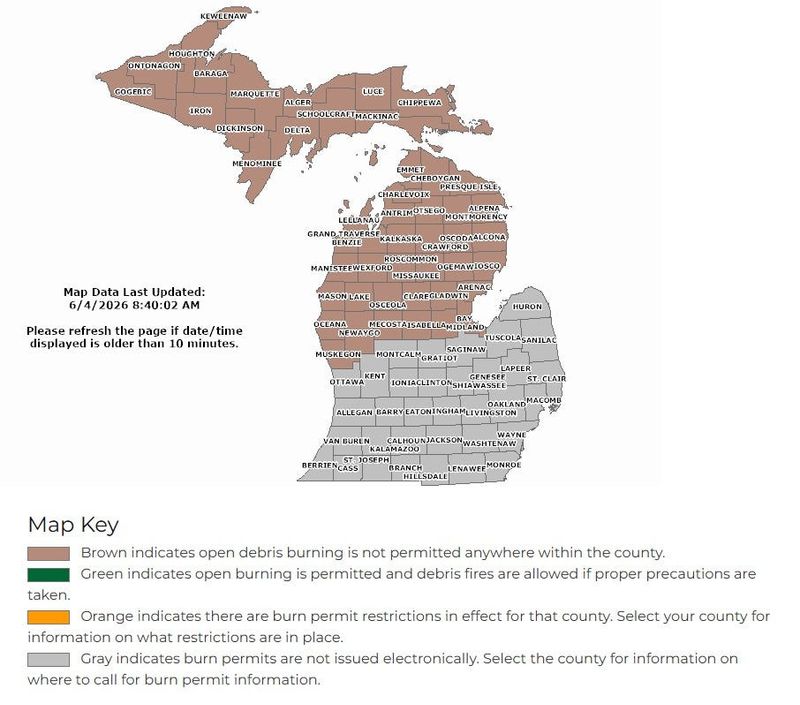
Ahead of rain showers, residents are urged to check current burning bans via the Michigan’s Department of Natural Resources’ online burn ban map.
As of Thursday morning, June 4, residents are prohibited to burn outdoors across the northern L.P. and entire U.P.
Here’s how to stay wildfire-aware and the live Michigan radar:
How can I check where burn bans have been issued?
The DNR updates the Michigan county map with burn permit information daily via the state’s burn permit management system webpage.
The map shows where burning is not permitted statewide. Residents may search their county name for restrictions per township.
“If ‘yes’ appears in the ‘Burning Permits Issued’ column on your county, you are authorized to burn today. This serves as your burn permit – you don’t need to print anything,” the DNR said.
Counties in the southern Lower Peninsula handle burn permits and bans individually, so check your local community’s fire information.
How can I check wildfire risk near me?
The Mesowest Great Lakes Fire and Fuels map shows the level of fire danger risk across Michigan each day.
There are five ratings: low, moderate, high, very high, and extreme risk. Ratings are determined by weather, fuels and fire occurrence data, according to the U.S. Forest Service.
Where is rain moving in Michigan? Live Doppler radar
Contact Sarah Moore @ smoore@lsj.com
This article originally appeared on Lansing State Journal: Extreme wildfire risks across Michigan. See where
Reporting by Sarah Moore, USA TODAY NETWORK / Lansing State Journal
USA TODAY Network via Reuters Connect
By Sarah Moore, USA TODAY NETWORK | USA TODAY Network