With water levels continuing to rise in rivers and dams, evacuations underway and more storms expected following a spate of tornadoes and damaging wind gusts in the state, northern Michigan residents took action to stay safe and take care of one another headed into the weekend.
Residents offered the use of their boats to neighbors along the Muskegon River.

School sports teams filled sandbags at their precarious local dam.
Emergency services personnel went door to door to tell people to evacuate, and officials eyed water that was inches from spilling over in Cheboygan.
Flooding had impacted several parts of northern Michigan by Thursday, April 16, and most of the Lower Peninsula remained under a flood warning or flood watch headed into the evening. While some of the advisories were scheduled to expire before Friday, April 17, others were set to continue until the evening of Sunday, April 19.
In the city of Newago, which boasts being the “Heart of the Muskegon River,” the Riverfront Park was flooded, and streets like that over the nearby bridge were closed, said Mayor Ed Fedell.
Earlier on Thursday, the Newaygo County Emergency Services ordered evacuations for those in the Muskegon River’s floodplain below the Croton Dam, including some residents in Fedell’s city.
Officials warned the flooding could be similar to or worse than 2014 flooding there, which was reported to have damaged hundreds of properties and resulted in several injuries.
If the river crests as expected, there will definitely be water entering some homes, the mayor said.
“Those houses may be completely (submerged),” he said of some homes along the river. His home is along it, too, but sits higher up.
The Muskegon River at Newaygo appeared to have surpassed its record by early Thursday afternoon, according to the NOAA Water Prediction Service. The major flood stage there is 15 feet, and the record was listed as 15.1 feet. The river was at 16.27 feet as of 1:45 p.m.
It also was far from the only area on high alert.
The Hesperia Dam — not unlike the well-watched Cheboygan dam — was among multiple such bits of infrastructure being closely eyed as dams across the region face pressure from melting snow and rain. Residents nearby were told to be prepared to evacuate. The Bellaire Dam in Antrim County was also being watched.
The worry, waiting and potential wading are expected to continue for multiple days, by the telling of the National Weather Service.
Fedell cautioned that even those who feel they are in safe spots in the area should be vigilant. And if law enforcement comes knocking and says to evacuate, residents “need to get out.”
The American Red Cross was out in northern Michigan, and shelters were being made available in multiple counties.
‘Ready’ in Bellaire
On a dreary, foggy morning in Bellaire, curious onlookers walked through downtown Bellaire to the Bellaire Dam, exchanging pleasantries.
One onlooker shouted to another across the street that her friends in California called her to say Bellaire made national news.
Darlene Hunt, a 73-year-old lifelong resident of Bellaire, was on a walk at Richardi Park with a view of the Bellaire Dam.
“I’ve never seen it like this,” Hunt said about the water levels. The creek that runs by her house flooded.
While her home isn’t in the area that officials say should be prepared to evacuate, she said she’s worried about the potential impact on local businesses.
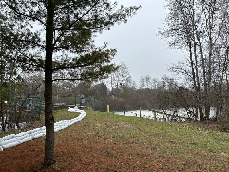
Water levels at the Bellaire Dam were stable the morning of April 16, but Antrim County officials said that due to the unpredictability of rainfall, the “Ready” protocol for the Intermediate River area downstream of the Bellaire Dam remained in place.
Antrim County officials also said they put plans in place to open evacuation centers at the Commission on Aging and Bellaire High School.
Getting out in Newaygo County
Public safety personnel were checking the area to ensure all had left the Muskegon River floodplain below the Croton Dam in Newaygo County, according to an alert Thursday morning announcing the evacuation. Another, sent about 11:30 a.m., warned that those who chose to remain would not have access to public safety services.
There were no concerns with the Croton and Hardy dams themselves, but flooding from the river had taken over multiple roads already, and others were expected to be affected as well.
Based on the forecast, river levels were expected to crest on Friday, April 17, through Saturday, April 18, according to a midmorning alert.
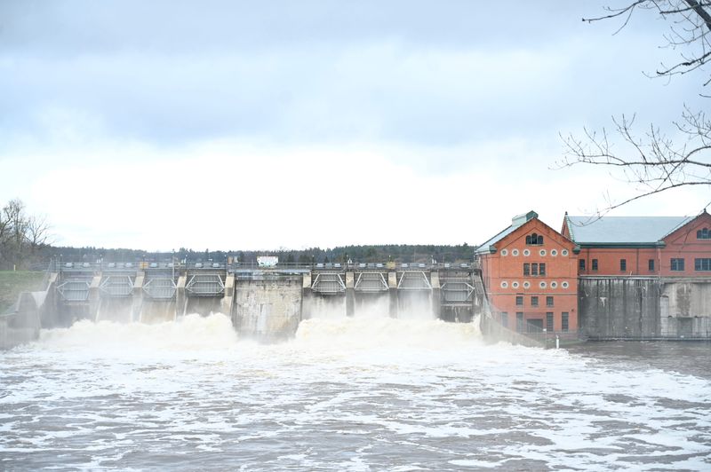
‘Set’ in Cheboygan
By midday Thursday, April 16, the water levels in the Cheboygan Lock and Dam Complex were a precarious 5.28 inches from the top.
That puts the level at the “set” stage of the “ready, set, go” plan in evacuation preparations — meaning that, by then, folks in the area were told to get set for the chance of evacuation.
As water levels at the Cheboygan dam in northern Michigan continued to rise, weather forecasters had both encouraging news and some that — to locals — is maybe not quite as reassuring.
While more rain would make matters worse, the downpour is not expected to be as much as what is expected in other places, said Sean Christensen, a National Weather Service meteorologist in Gaylord.
“Obviously, any little bit of rain is not ideal,” he said.
Only about a tenth of an inch was expected to fall on Thursday. Friday to Saturday, more rain — about one-third to one-half inch — is expected.
By Saturday into Sunday, temperatures are expected to drop, which would turn the rain to snow. That could help slow any remaining snowmelt and water from adding to the Cheboygan River’s flow.
For the less hopeful news: Water could still spill over the dam. The fear is that a deluge could take out homes and businesses and put people who didn’t evacuate in danger.
Forecasters, Christensen said, don’t have enough data — historically or from river water gauges — to predict exactly when the river might spill over or whether all that water and pressure from it is too much for the dam to handle.
Engineers have added sandbags and pumps to help.
“In terms of flow, we are expecting an increase as we head into this weekend, and it’s probably going to peak right around the 18th, 19th or maybe even the 20th,” the meteorologist said.
That’s Saturday, Sunday or Monday.
Flow is how much water is moving through the river, which is connected to the height, how much water is above the water level base. In this case, Christensen said, the weather service doesn’t have many gauges on the river to predict a spillover.
“With the Cheboygan River only 6-7 inches from the top of the dam, that’s obviously a concern for everyone down there in Cheboygan,” he said. “We’re just going to continue to monitor things, and thankfully, we’re not seeing a ton of rain in the forecast.”
So, in scientific terms, are the next few days iffy?
“Ah, yeah,” Christensen said, “I guess that’s fair to say.”
This article originally appeared on Detroit Free Press: Evacuations, rising waters and an ‘iffy’ weekend ahead in Michigan
Reporting by Darcie Moran, Frank Witsil, Adrienne Roberts and Tanya Wildt, Detroit Free Press / Detroit Free Press
USA TODAY Network via Reuters Connect