
A strong area of high pressure over the area will continue to bring excessive heat leading up to the July 4 holiday as a sprawling heat dome sets up over much of the central and eastern United States.
“The extreme heat will impact everything from everyday life to beach vacations and outdoor cookouts to watching the fireworks,” according to AccuWeather.

Heat indices in the western Florida Panhandle are expected to reach 109 degrees on Monday, which is cooler than the rest of Florida.
Heat advisories were issued in 41 Florida counties on Monday. Escambia, Santa Rosa and Okaloosa counties were the only Panhandle counties not under a heat advisory.
Moisture will return to the Pensacola area starting on Tuesday, bringing a slight chance of afternoon showers and storms, but don’t expect any relief from the sweltering heat.
Why isn’t Pensacola under a heat advisory?
There isn’t a standard guideline on when National Weather Service offices will issue heat advisories because some areas are better equipped to handle heat than others.
NWS offices typically rely on heat index values and how long they will last. Parts of Pensacola are forecast to see feels-like temperatures potentially reach 109 degrees on Monday, which is usually enough to trigger a heat advisory.
Not all of Pensacola will get that hot, however. The NWS’s hourly forecast shows the heat index rise above 100 degrees around 11 a.m. It is set to peak at 109 degrees around 3 p.m., and then immediately drop.
July 4 weather forecast for Pensacola, Escambia and Santa Rosa counties
The Pensacola area is forecast to have a hot and potentially rainy July 4.
Highs across Escambia and Santa Rosa counties are expected to reach about 94 degrees. Southern parts of the counties have a 40% chance of precipitation, while northern ends are up slightly at 60%.
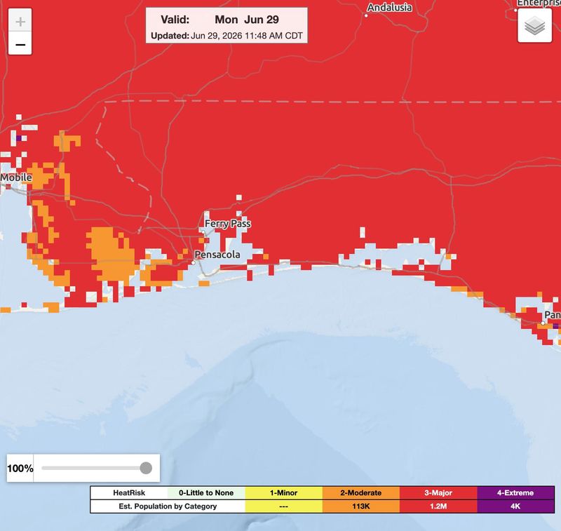
What is the HeatRisk in the Pensacola area?
Most of the Pensacola area is forecast to have a HeatRisk index of 3 through the first week of July. Some parts fo the area will hit level 4 by July 4.
There are five levels of HeatRisk, numbered between 0 and 4. A red (3) HeatRisk indicates that anyone without cooling and access to hydration and health systems are at risk.
A magenta (4) HeatRisk indicates an extended period of extreme heat with no overnight relief, according to the NWS.
What is HeatRisk?
The National Weather Service uses several tools to assess increased heat stress from extreme temperatures, which are used to issue heat watches, warnings and advisories.
HeatRisk is an experimental service that identifies unusual heat that could lead to increased heat-related impacts. It then attempts to categorize those risks into five levels.
This article originally appeared on Pensacola News Journal: Heat dome brings dangerous temps to Pensacola area on July 4
Reporting by Brandon Girod, Pensacola News Journal / Pensacola News Journal
USA TODAY Network via Reuters Connect
By Brandon Girod, Pensacola News Journal | USA TODAY Network