A cold front is bringing some chilly weather to the Milwaukee area this week – but it will be short-lived, as a warm weekend looks to be in the near future.
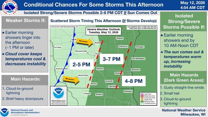
Denny VanCleve, a meteorologist with the National Weather Service in Milwaukee/Sullivan, said a cold front is moving into southeastern Wisconsin Tuesday, May 12, bringing some showers with it.

Ahead of the cold front, rain will likely hit the Milwaukee area around late morning and early afternoon. There may not be much rain, depending on how much the system weakens by the time it hits Milwaukee, VanCleve said.
After that, there will likely be a break in the rainfall, with temperatures potentially getting as warm as low 70s.
“Because the cold front is still to the west, we’re going to have breezy southwest winds ahead of the front, which is going to get us nice and mild today – especially if we are able to pop any sun this afternoon,” VanCleve said.
Wind gusts could reach as high as 35 or 40 mph, he added.
By late afternoon and early evening, thunderstorms are possible as the cold front nears. The cold front will hit the Milwaukee area by around 8 p.m. or 9 p.m., VanCleve said.
“It’ll move through the Milwaukee area, and then we’ll cool off to 40s tonight, and the high is only around 60 [on Wednesday, May 13],” he said.
The cooler temperatures are expected to last Wednesday and Thursday, May 14, before a weekend warm-up.
By Friday, May 15, Milwaukee’s temps will likely reach mid-70s, and may even get close to 80 degrees by Saturday, May 16.
The next likely possibility for rain after May 12 will be between May 14 and May 15, as the warmer air mass pushes back into the area.
Contact Kelli Arseneau at (920) 213-3721 or karseneau@gannett.com. Follow her on X at @ArseneauKelli.
This article originally appeared on Milwaukee Journal Sentinel: Cold front, rain, possible thunderstorms forecast for Milwaukee on May 12
Reporting by Kelli Arseneau, Milwaukee Journal Sentinel / Milwaukee Journal Sentinel
USA TODAY Network via Reuters Connect