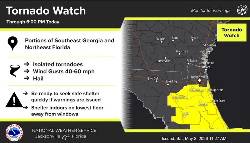
DAYTONA BEACH — The National Weather Service issued tornado watches for Volusia and Flagler counties, effective through 6 p.m. today, May 2.
The tornado watches went into effect at 11:25 a.m. today for 21 Florida counties, including Brevard, Seminole and Orange.

A wind advisory is also in effect for Volusia County today until to 6 p.m. Windy conditions are expected around 1 p.m., with wind gusts up to 35 mph, according to NWS.
At 11:45 a.m. today, winds in Volusia were already 13 mph with gusts up to 25 mph.
Strong storms are possible in central Florida today as unsettled weather moves through. The chance of rain increases about 7 p.m. tonight, and lasts until about 10 p.m.
Steady southwest winds of 15 to 20 mph are expected today, with gusts as high as 35 mph in some locations. Chance of precipitation is 60%. Rainfall will be between a 10th and quarter of an inch, with higher amounts possible in thunderstorms.
➤ Jacksonville weather radar
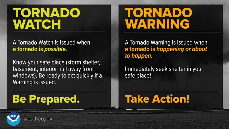
What is a tornado watch?
Be prepared! Tornadoes are possible in and near the watch area. Review and discuss your emergency plans, take inventory of your supplies and check your safe room. Be ready to act quickly if a warning is issued or you suspect a tornado is approaching. Acting early helps to save lives! Watches are issued by the Storm Prediction Center for counties where tornadoes may occur. The watch area is typically large, covering numerous counties or even states.
What is a tornado warning?
Take Action! A tornado has been sighted or indicated by weather radar. There is imminent danger to life and property. Move to an interior room on the lowest floor of a sturdy building. Avoid windows. If in a mobile home, a vehicle, or outdoors, move to the closest substantial shelter and protect yourself from flying debris. Warnings are issued by your local forecast office. Warnings typically encompass a much smaller area (around the size of a city or small county) that may be impacted by a tornado identified by a forecaster on radar or by a trained spotter/law enforcement who is watching the storm.
What should you do during a tornado?
How can you protect yourself from a tornado? Here’s advice from the National Weather Service:
One of the best ways is to listen for tornado warnings issued by the National Weather Service. The fastest access to those warnings is through a NOAA Weather Radio, available for purchase at commercial electronics stores.
Otherwise, the best clue that a tornado is approaching is the tell-tale roaring or rumbling sound they make. If you hear this, or a National Weather Service warning for your area, take cover quickly.
Find a small, interior room on the lowest floor of a strong building and stay away from doors and windows.
Don’t try to outrun a tornado in a car. If you see a tornado while in a car, take cover in a nearby strong building or get into a ditch on the side of the road.
What’s the temperature today in Daytona Beach?
Despite the clouds, temperatures will reach the high 80s today before dropping back down into the 70s around 6 p.m. Chances for rain are about 60% today, the NWS in Melbourne said.
Tonight’s forecast calls for a chance of showers and thunderstorms before 2 a.m., then a slight chance of showers between 2 a.m. and 3 a.m. It will be cloudy, with a low around 63.
There will be a north wind tonight of 10-15 mph, with gusts as high as 25 mph. Chance of precipitation is 50%. New rainfall amounts could be between a tenth and quarter of an inch, with higher amounts possible in thunderstorms.
The sun will return Sunday, but temperatures will slide down into more comfortable mid-70s May 3 and 4. The 80s return May 5 and the high May 7 is forecast at 90 degrees.
It will remain windy May 3 with north and northeast winds around 15 mph, and gusts as high as 25 mph.
Chances for rain after today stay low until May 11.
Palm Coast weather
Strong thunderstorms are expected to impact Flagler County this afternoon through 2 p.m. with wind gusts of around 40 to 50 mph, according to the NWS. Residents are encouraged to secure outdoor objects and seek shelter indoors if possible.
Showers and thunderstorms will continue throughout the afternoon, with a high of 87. Evening showers and thunderstorms will continue into the evening until about 11 p.m. Expect a low of around 60, with a 60% chance of rain possible overnight, according to the NWS.
Expect sunny and breezy weather Sunday and Monday, highs in the low 70s and overnight lows in the mid 60s, the NWS said.
Former Staff Writer Jim Abbott contributed to this story.
This article originally appeared on The Daytona Beach News-Journal: Volusia, Flagler under tornado watch. Rain, high winds in forecast
Reporting by Eileen Zaffiro-Kean and Ashley Varese, Daytona Beach News-Journal / The Daytona Beach News-Journal
USA TODAY Network via Reuters Connect