A storm system is expected to sweep across parts of Iowa on Monday, April 27, bringing with it the possibility of large hail and tornadoes.
The risk of severe weather has been downgraded from earlier forecasts, the National Weather Service said. A line of strong storms in Missouri on Monday morning brought cooler air to the region, reducing the available energy for storms to form. Enough energy could rebuild for strong storms to form later today, primarily in southeast Iowa.

Here’s what to know.
What is the severe weather outlook in Iowa for the next 24 hours?
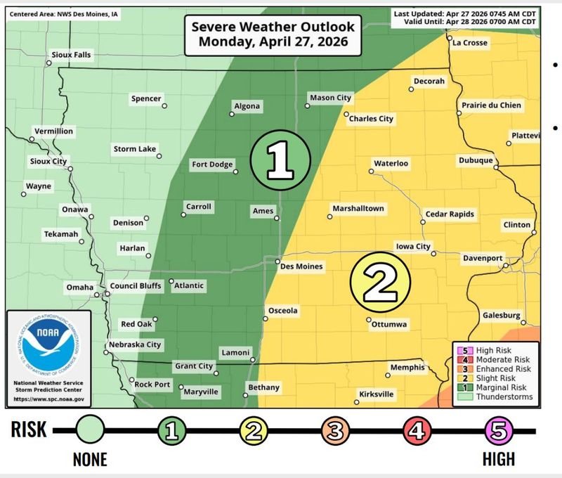
A slight, or Level 2 (out of 5), risk is in place for parts of central Iowa to the east of Interstate 35 and the eastern half of the state on Monday, according to the National Weather Service office in Des Moines. Western Iowa remains under no severe risk, while central Iowa, running roughly north–south, is under a Level 1 risk.
Storms will move quickly — around 45 mph — from central Iowa into eastern Iowa, with hail up to 3.5 inches posing the biggest risk, wind gusts of 60 mph and an increasing tornado threat in eastern Iowa.
Will there be tornadoes in Iowa on Monday?
Any tornadoes that do form could reach EF‑2 strength, the NWS said.
Des Moines is in the 2–5% tornado probability range. The highest probability range for tornadoes, 5–9%, is in far southeast Iowa, stretching from Keokuk to past the Quad Cities and into Clinton.
See the weather radar to track storms
What’s the forecast for Des Moines?
The odds of showers and thunderstorms in Des Moines increase as the afternoon approaches. It’ll be breezy, with winds blowing from the south at 13 to 17 mph, with gusts up to 28 mph. The chance of precipitation is 100%, according to the NWS office in Des Moines. The high is 72.
Monday night will be mostly cloudy, with a low around 43 and west-northwest wind gusts up to 30 mph.
Are there any weather warnings in Iowa?
Track the latest severe thunderstorm or tornado warnings with the map below:
Get weather updates
Cooper Worth is a service/trending reporter for the Des Moines Register. Reach him at cworth@gannett.com or follow him on X @CooperAWorth.
This article originally appeared on Des Moines Register: Tornadoes, severe storms still possible in Iowa. Track the radar.
Reporting by Cooper Worth, Des Moines Register / Des Moines Register
USA TODAY Network via Reuters Connect