This winter’s harsh run in the East is intensifying, with some of the coldest air so far this season plunging into New York this weekend as a mass of Arctic air drops south from Canada.
“A brutally cold weekend awaits more than 100 million people in the northeastern quarter of the nation as Arctic air lunges southward straight from eastern Canada,” AccuWeather senior meteorologist Alex Sosnowski said in an online forecast.

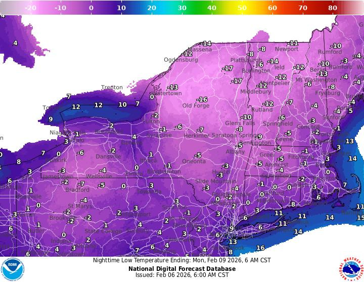
Temperatures will drop into the single digits or below zero across much of the Northeast, AccuWeather predicts. Dozens of daily record cold temperatures will be in jeopardy both on Saturday, Feb. 7 and Sunday, Feb. 8, according to Weather.com.
“This weekend could feature the coldest air of the whole winter in the Northeast and Mid-Atlantic,” said Washington Post meteorologist Ben Noll on X.
How cold will New York get? See the maps
The National Weather Service has upgraded parts of New York to Extreme Cold Warnings or Cold Weather Advisories for the weekend, citing life-threatening wind chills.
According to the National Weather Service office in Buffalo, wind chills between 15 and 35 below zero are expected, with the coldest values across interior sections of western and central New York, the Finger Lakes and areas east of Lake Ontario.
Low temperatures are forecast to drop to near zero or several degrees below by Saturday morning, with daytime highs struggling to climb out of the single digits. Strong winds behind the Arctic front will make conditions feel even colder.
Snow, squalls and damaging winds
Snow is expected to spread across much of the state Friday, Feb. 6, as a weak low pressure system and Arctic cold front move through. The National Weather Service said some snow could be heavy at times Friday evening into early Saturday, especially along the cold front, with brief snow squalls possible.
Wind gusts could reach 40 mph or higher, leading to blowing and drifting snow and sharply reduced visibility. Forecasters warn that isolated power outages and minor tree damage are possible, particularly in higher terrain and areas exposed to the strongest winds.
Behind the front, lake-effect snow is expected to develop downwind of Lake Ontario from Saturday into Sunday, with light additional accumulations but continued hazardous travel.
“Widespread snow expected today and tonight as a weak low and an Arctic cold front cross the region, some of the snow may be heavy later this evening with potential squalls and along the cold front,” the National Weather Service in Buffalo wrote. “Wrap around moisture and lake effect snow will develop behind the Arctic cold front Saturday through Saturday night, with blowing and drifting of the fresh snowpack.”
Is the polar vortex to blame?
Yes — but not in the way many people think.
A lobe of the polar vortex at lower levels of the atmosphere (known as the “tropospheric polar vortex”) is responsible for this intense cold, noted Weather Trader meteorologist Ryan Maue in an e-mail to USA TODAY.
But that lower-level feature is not the polar vortex meteorologists usually refer to when talking about major disruptions like we’ve seen several times this winter. The true polar vortex sits much higher in the atmosphere — roughly 10 to 30 miles up in the stratosphere — where a recent warming event has begun to affect circulation patterns.
“There is a vortex in the troposphere that we live in. But I don’t like to call it a ‘polar vortex’ because people leave it alone and call it that,” said Paul Pastelok, Lead Long-Range Expert for AccuWeather. “It’s not the same as the actual polar vortex that usually gets disrupted (from stratospheric warming). This is what we call the ‘polar jet stream’ — these upper-level lobes.
“In the stratosphere there’s just one polar vortex sitting over the pole that gets disrupted. And it links down into the atmosphere and gets caught up in the polar jet stream, and that is the drive,” he added.
The stratospheric warming has weakened the high-altitude vortex slightly, which nudges the polar jet stream and allows some Arctic air to escape. But the more noticeable, long-term impacts from the stratospheric disruption is heading toward Eurasia, while the eastern U.S. sees a faster, shorter-lived surge of frigid temperatures, Pastelok said.
Still, the polar vortex itself is not moving into New York or directly delivering the cold. Its role is to contain Arctic air near the pole. Changes in the jet stream and pressure patterns — set in motion by the stratospheric disruption — allow some of that cold air to spill south, producing the Arctic outbreak we’re experiencing.
How does stratospheric disruption occur?
A sudden stratospheric warming (SSW) occurs when an intense area of high pressure in the lower atmosphere sends energy upward into the stratosphere, Pastelok said. This can raise temperatures in the polar stratosphere by 20–40°F (10–20°C) over just a few days.
The warming slows the zonal winds — the fast, circular winds that normally rotate around the polar vortex. When these winds slow, the vortex can become less stable and wobble, shift or even split. That wobbling can allow Arctic air from the troposphere — or contained within the polar jet stream — to move elsewhere.
Not every stratospheric disruption weakens the polar vortex, and even a weakened vortex does not automatically bring cold to the mid-latitudes. The effects depend on the strength, timing and structure of the wave forcing and how it couples down from the stratosphere to the lower atmosphere.
Even if Arctic air from the disrupted polar vortex reaches the U.S., it doesn’t guarantee snow or ice — those require additional systems with sufficient moisture.
Has the polar vortex been more active this year?
When it’s strong, Arctic air stays locked inside the polar vortex — a circulation of winds surrounding the North Pole.
This year, the polar vortex has been weaker than usual, which allows it to influence the lower atmosphere more frequently, making it appear more active than normal, even though the polar vortex’s overall strength and coherence are lower than typical.
New York weather watches and warnings
Stay informed. Get weather alerts via text
Brandi D. Addison covers weather across the United States as the Weather Connect Reporter for the USA TODAY Network. She can be reached at baddison@gannett.com. Find her on Facebook here.
This article originally appeared on Rochester Democrat and Chronicle: How cold will New York get? See the latest weather maps
Reporting by Brandi D. Addison and Doyle Rice, USA TODAY NETWORK / Rochester Democrat and Chronicle
USA TODAY Network via Reuters Connect