A disorganized tropical disturbance means Florida and the coastal Southeastern U.S. are in for a rainy wind-up to the Independence Day weekend, and unfortunately, with Florida’s tough new anti-weather modification laws now in effect, there’s nothing we can do about it.
Kidding aside, the good news is that eventual tropical development of this feature, if any, should be limited, and is no cause for alarm.

Here’s a quick review of tropical goings-on to free up your mental capacity to steal the Articles of Confederation to recover Benny Frank’s Masonic popcorn shrimp recipe on the back of it, repel alien invasions, ride the highway to the danger zone, and generally celebrate your country by blowing up a small piece of it this holiday weekend.
Will Florida see tropical storm over Fourth of July holiday weekend?
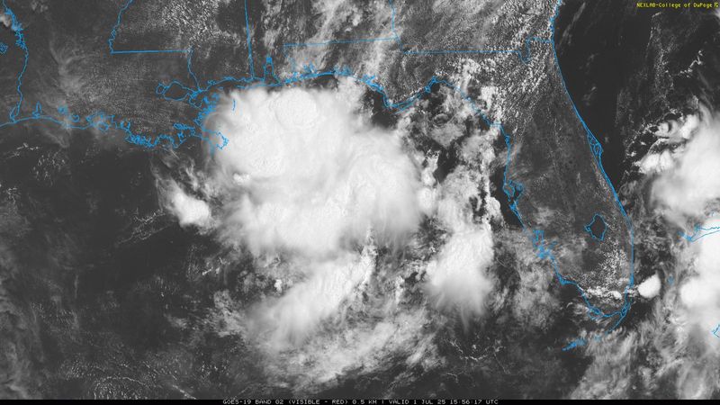
Florida tropical threat synopsis: Disorganized convection in the eastern Gulf has a modest chance of organizing into a tropical system over the long weekend, either in the northeastern Gulf or more probably east of Florida. Elevated rain coverage will continue over Florida for another 2-4 days before likely diminishing from north to south over the long weekend.
Almanac: It’s Tuesday, July 1st… day 32 of the 2025 hurricane season, 151 days to go. By total storm energy, the season is 2.6%, 7.9%, and 6.9% complete for the Atlantic, continental U.S., and Florida, respectively.
July is the second-quietest month of hurricane season from a U.S. landfall perspective, historically trailed only by November, with a pronounced historical lull in storm impacts mid-month.
The most common location for tropical activity to develop in the first half of July is east of Florida and the Carolinas, with a smattering elsewhere across the Gulf, Caribbean, and western tropical Atlantic. A storm develops in the first two weeks of July every three years or so.
Active storms: None.
July Fourth forecast: North Florida drying out, but peninsula could see a beneficial rainmaker
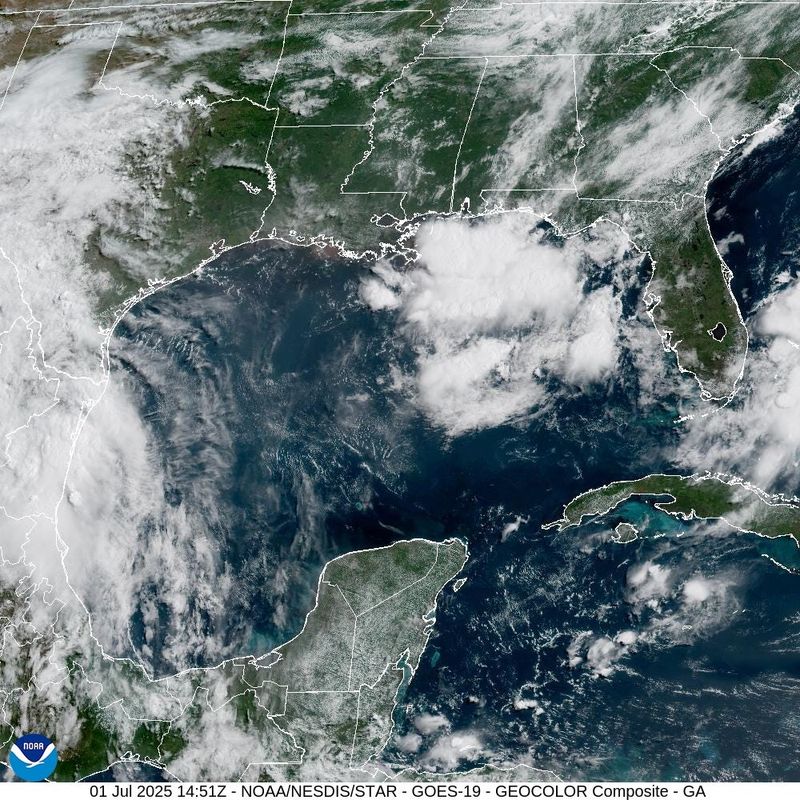
Disturbances in NHC tropical weather outlook: A broad disorganized area of convection extends from the eastern Gulf south of the Panhandle to east of the Bahamas, where an upper-level low is enhancing storms along an old, stalled-out frontal boundary. As of early Tuesday afternoon, the NHC is giving this mess a 30% chance of tropical development over the next seven days, as a more organized low could form somewhere along that trough, most likely between July 4 and July 6.
Right now, what weak spin there is in the lower atmosphere is centered near the northeastern Gulf and will keep North Florida soggy through at least Thursday, July 3. However, drier air pushing into the Central Gulf mid-week should start to diminish rain chances in the Panhandle by the 4th, and will make the area near or east of Florida the more likely focus of any potential tropical development.
The minority of computer model ensembles showing a weak storm forming have been steadily shifting their development clusters east in the last couple of days, so I think an organized low forming in the Gulf is pretty unlikely.
If tropical system does eventually develop east of Florida or south of the Carolinas, steering currents are light, so it could well linger near the Gulf Stream into next week. Dry air and some northerly wind shear would most likely keep anything that develops weak.
That means that whether or not a tropical depression or tropical storm develops, the primary impact on Florida and the southeast coast for the upcoming week is rainfall.
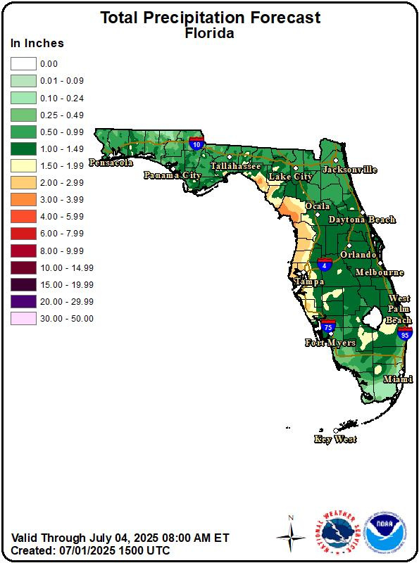
Expected rainfall totals over the five days across most of Florida and the eastern Gulf Coast are in the 2-4” range, with locally higher accumulations and slight chances of localized flash flooding. North Florida rain chances will decline in a few days, but the Florida peninsula will see elevated rain coverage through the weekend.
That’s good for the drought, though not good for enjoying all-American novelties. Bottom line, expect thunderstorms across Florida to be enhanced by this tropical disturbance for another three to six days, but little chance of weather much different from a higher-than-normal dose of typical daily storms.
Expect the quiet start of hurricane season 2025 to continue
Elsewhere: No need for cloud seeding, conventional weapons, nuclear weapons, HAARP, or MOABs: there’s nothing else going on in the Tropical Atlantic Basin over the upcoming week.
Wind shear remains high and dust remains extensive across the Caribbean and eastern Atlantic, and no tropical development is expected elsewhere through the first 10 days of the month.
July weather tends to tell us a lot about the peak months of hurricane season, so I’ll be carefully monitoring trends and have a full refresh of WeatherTiger’s seasonal landfall risk outlook at the end of the month.
Loss of satellite data will impact forecasts going forward
Finally, I’ve gotten a lot of questions about the possible loss of microwave satellite data and how it would affect hurricane forecasts. This data has been routinely provided by military satellites for decades, and allows forecasters to see through clouds and get an accurate snapshot of key storm structures, day or night.
Last week, it was unceremoniously announced this data stream was shuttering, with even the NHC slated to lose access.
Unfortunately, if that happens, it will be quite impactful for all forecasters, harming our ability to detect and forecast rapid intensification, among much else. Yesterday, the data cutoff was delayed a month to July 31, but that scarcely helps as 80% of major hurricanes happen between mid-August and mid-October, so let’s hope for another reprieve.
I’ll have a more in-depth look this and other missing forecast tools down the road, as well.
Next report: Hopefully no need for additional forecasts over the weekend. In the meantime, keep watching the skies for both plastic bags drifting through the wind and fireworks.
Dr. Ryan Truchelut is chief meteorologist at WeatherTiger, a Tallahassee company providing forensic meteorology expert witness services and agricultural and hurricane forecasting subscriptions. Email Ryan Truchelut at ryan@weathertiger.com
This article originally appeared on Tallahassee Democrat: Florida hurricane forecast: How tropical turbulence will impact your Fourth of July
Reporting by Ryan Truchelut / Tallahassee Democrat
USA TODAY Network via Reuters Connect