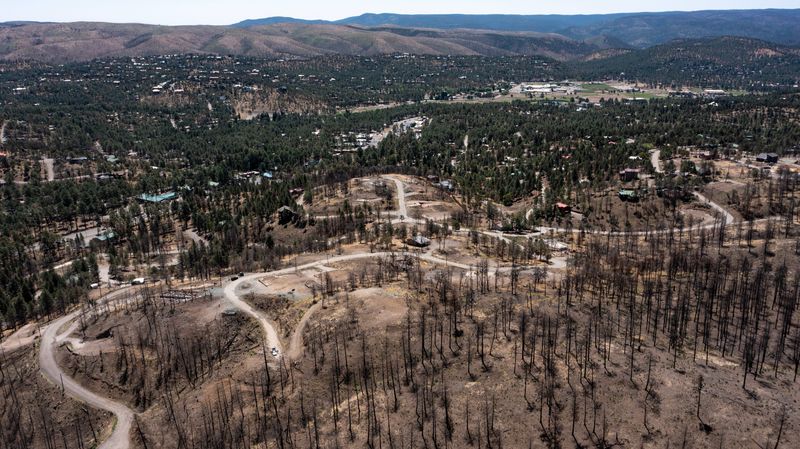
As monsoon rain heads into the Ruidoso area, burn scars left behind from last year’s South Fork and Salt Fire have the potential to turn even the smallest amount of rain into dangerous runoff, especially in flood-prone areas.
Thunderstorms are expected to continue over the Sacramento Mountains on Friday, June 20, with more moisture moving into the region over the weekend and into next week, according to Mike Hardiman, forecaster with the National Weather Service.

“We have a nice plume of moisture coming up from Mexico that really establishes itself on Sunday,” Hardiman said. “It doesn’t look like it’s going to go anywhere for a while. Once we get into Sunday, Monday, and Tuesday, we have the most moisture over the area, and every day you’re going to get thunderstorms.”
While the monsoon officially began a few days ago, Ruidoso had already experienced heavy flooding during a storm on June 19, when roads were once again transformed into rivers and drainage areas were filled with moving water. A viral video captured people racing up stairs as flooding moved through Brady Canyon.
The images are similar to what Ruidoso experienced in 2024, after the South Fork and Salt Fire ravaged the terrain. The burn scars left behind from the wildfires continue to impact flooding and may persist for years to come, Hardiman said.
“It’s just going to be a case of dumb luck whether you get a storm to form over the wrong place at the wrong time — the wrong place in this case being the burn scars,” Hardiman said. “That’s what happened yesterday (June 19), there wasn’t a lot of thunderstorms across the Sacramento Mountains, it just happened to form in the worst spot.”
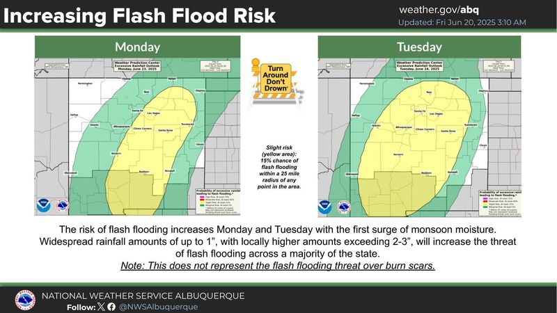
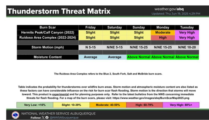
While thunderstorms brewing over burn scars are a continuous threat, there is a higher probability that rain will hit the areas impacted by last year’s wildfires on Monday and Tuesday, June 23-24, according to the National Weather Service.
With a daily threat of flooding during the monsoon, Hardiman said to always heed warnings from local emergency management and understand where the flood-prone areas are located. The areas around drainage are where water accumulates the most, but debris under bridges can also disperse water in places that don’t normally get flooding, Hardiman explained.
“I wouldn’t let it (the rain) ruin my plans, but I would adjust my plans,” he said. “It’s not the best time to be planning a picnic on the Rio Ruidoso. Just keep yourself as informed as possible.”
Ruidoso provides map with real-time road updates
If you are a Ruidoso resident or planning a visit, the village has released a real-time road conditions map.
The RAIN (Ruidoso Alert Information Network) map is provided to inform the public about flooded roads and is continuously updated, according to the Village of Ruidoso.
The map also displays any active wildfires in the area.
What do I do before a flood?
Sometimes floods develop slowly, and forecasters can anticipate where a flood will happen days or weeks before it occurs. Often, flash floods can occur within minutes, sometimes without any visible sign of rain. Being prepared can save your life and give you peace of mind.
Safety tips during a flood
During a flood, water levels and the rate at which the water is flowing can quickly change. Stay informed and monitor local radio and television stations. Avoid flood waters at all costs and evacuate immediately when water starts to rise.
Natassia Paloma may be reached at npaloma@gannett.com, @NatassiaPaloma on X; natassia_paloma on Instagram, and Natassia Paloma Thompson on Facebook.
This article originally appeared on El Paso Times: Monsoon storms brewing over burn scars may create daily flooding threat in Ruidoso
Reporting by Natassia Paloma, El Paso Times / El Paso Times
USA TODAY Network via Reuters Connect