The first thunderstorm of the 2026 season is expected to move through Central Wisconsin overnight March 6-7, bringing lightning, hail and rumbles of thunder.
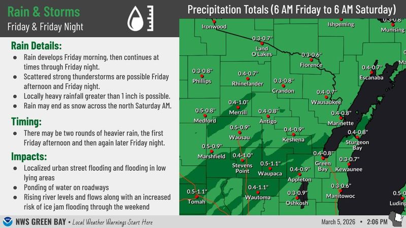
Two rounds of moderate rainfall, which could bring over 1 inch of rain, will also move across Central Wisconsin from the southwest. One round is expected during the afternoon March 6 and the second, a heavier round, during the overnight hours into March 7, Jason Alumbaugh, meteorologist at the National Weather Service in Green Bay, told a USA TODAY NETWORK-Wisconsin reporter.

The still-frozen ground and ice on rivers may contribute to instances of localized flooding, Alumbaugh said.
The heavier round of rainfall with a low severe weather threat will move across the region beginning around 10 p.m. and taper off by daybreak, Alumbaugh said. This round will bring gusty wind, brief periods of heavy rain and potential for small hail.
Most of Central Wisconsin will only see rainfall but the most northern areas might see mixed precipitation including freezing rain and sleet, which could change to snow. The areas with the best chance to see accumulating snow will be near Vilas County, Alumbaugh said.
Rainfall could lead to flooding in some areas
Rivers, streams, and creeks are expected to rise to bank-full levels and potential for ice jams may cause waterways to reach flood levels, Alumbaugh said. Other impacts to look out for on Saturday morning include localized flooding in low-lying areas and fallen tree limbs.
A look ahead at temperatures and fire risks
Scattered showers and temperatures in the mid-40s are expected for Saturday before rising to near 60 and above for March 8 and March 9, Alumbaugh said.
The rounds of rain will dampen what was expected to be an elevated fire weather day on March 9, Alumbaugh said, but concern for elevated fire risks due to recent dry conditions will continue until there is more precipitation.
A cold front will move into the area on March 10 bringing high temperatures in the 40s and mid- to high-30s on March 11, Alumbaugh said.
Erik Pfantz covers local government and education in central Wisconsin for USA TODAY NETWORK-Wisconsin and values his background as a rural Wisconsinite. Contact him at epfantz@usatodayco.com.
This article originally appeared on Stevens Point Journal: First storm of 2026 could bring heavy rain, hail & wind to Central WI
Reporting by Erik Pfantz, USA TODAY NETWORK – Wisconsin / Stevens Point Journal
USA TODAY Network via Reuters Connect