Update, 2:30 p.m.: A tornado watch is in place for southeast Indiana counties just west of Cincinnati until 9 p.m., according to the National Weather Service.
Indiana counties in Greater Cincinnati included in this watch are Ohio, Switzerland, Dearborn, and Franklin. No counties in southwest Ohio nor Boone, Kenton and Campbell counties have been placed under the watch as of 2:30 p.m.

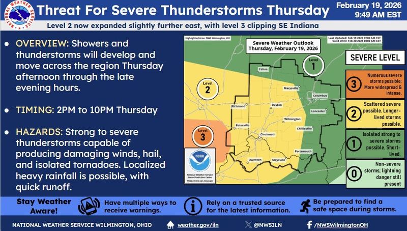
According to the watch, scattered severe thunderstorms will be capable of producing large hail, damaging winds and isolated tornadoes. Also, localized flooding will be possible.
Original coverage: Cincinnati weather is acting up again with near-record highs and storms possible Thursday and a chance of snow this weekend. Why pick a season when you can have all of them in 72 hours?
The region is bracing for a round of potentially severe thunderstorms as unseasonably warm air and a strong storm system move across the Ohio Valley. Forecasters warn that the combination could bring damaging winds, large hail, and even an isolated tornado before a cold front sweeps through overnight.
The National Weather Service has bumped up the greatest risk for severe weather to fall between 2 and 10 p.m. Thunderstorms developing over Indiana and Kentucky are expected to push into Southwest Ohio.
The day started out foggy and unusually warm. Temperatures are expected to climb into the upper 60s through the day, roughly 20 degrees above normal for this time of year. Despite the surge in warmth, the record high of 74 degrees at CVG set in 1939 is not expected to be broken.
Cold front brings strong winds Friday
The system’s cold front is forecast to move through the region early Friday, ushering in much drier and cooler air. Behind it, strong low pressure over the Great Lakes is expected to produce afternoon wind gusts of 35 to 40 mph.
Those gusts may make driving difficult for high-profile vehicles and could cause minor tree limb damage or scattered power issues.
Cold is returning to Cincinnati
Cincinnati had a record high temperature for Feb. 18 of 68 degrees, but temperatures will start dropping Friday.
A shift to colder weather arrives early next weeks.
High temperatures on Monday are expected to only reach the lower to mid-30s, with overnight lows dropping into the teens by early Tuesday, which will be the coldest period of the upcoming week.
Cincinnati weather forecast
Thursday: Widespread fog and a chance of rain before 8 a.m, then widespread fog and a chance of rain showers between 8 a.m and 1 p.m, then a chance of showers and thunderstorms. Mostly cloudy, with a high near 68. South wind 3 to 9 mph. Chance of precipitation is 30%. New rainfall amounts less than a tenth of an inch possible.
Thursday night: Showers and thunderstorms before 1 a.m, then a chance of rain and a slight chance of thunderstorms between 1 a.m and 3 a.m, then a slight chance of thunderstorms and a slight chance of rain between 3 a.m and 4 a.m. Mostly cloudy, with a low around 47. South wind around 8 mph. Chance of precipitation is 80%. New rainfall amounts between a tenth and quarter of an inch possible.
Friday: Sunny, with a high near 55. Southwest wind 9 to 17 mph, with gusts as high as 33 mph. New rainfall amounts less than a tenth of an inch possible.
Friday night: Partly cloudy, with a low around 33. West wind 2 to 13 mph.
Saturday: Mostly sunny, with a high near 50. West wind 2 to 7 mph.
Saturday night: A slight chance of rain between 7 p.m and 1 a.m, then a slight chance of rain and snow. Mostly cloudy, with a low around 30. Chance of precipitation is 20%.
Sunday: A slight chance of snow before 1 p.m. Mostly cloudy, with a high near 39.
Sunday night: Mostly cloudy, with a low around 26.
Monday: Mostly cloudy, with a high near 36.
Monday night: Partly cloudy, with a low around 22.
Tuesday: Mostly sunny, with a high near 41.
Tuesday night: Mostly cloudy, with a low around 31.
Wednesday: A slight chance of rain after 1 p.m. Mostly cloudy, with a high near 51.
Wednesday night: A chance of rain. Mostly cloudy, with a low around 37.
Source: National Weather Service in Wilmington
This article originally appeared on Cincinnati Enquirer: Indiana counties just outside Cincinnati under tornado watch
Reporting by Gillian Stawiszynski and Cheryl Vari, Cincinnati Enquirer / Cincinnati Enquirer
USA TODAY Network via Reuters Connect