Editor’s Note: A previous version of this story incorrectly stated what day the possibility of severe weather was forecast.
A tornado warning has expired but a severe thunderstorm warning remains in effect for Licking County until 10:15 p.m. Tuesday, April 14, according to the National Weather Service in Wilmington.

Also at 9:30 p.m., the weather service reported a severe thunderstorm was located over Granville, moving east at 50 mph. Locations impacted include… Newark, Heath, Granville, Buckeye Lake, Hebron, Utica, Hanover, Harbor Hills, Marne, Beechwood Trails, Thornport, Kirkersville, Alexandria, St. Louisville, Gratiot, Brownsville, and Purity. This also includes I-70 in Ohio between mile markers 124 and 142.
Meteorologists warn of wind gusts as strong as 60 mph. Use caution, officials warn of hail as large as 0.75 inches. Expect damage to trees and power lines, the weather service said.
The NWS warns: “For your protection move to an interior room on the lowest floor of a building. To report severe weather, go to our website at weather.gov/iln and submit your report via social media, when you can do so safely.”
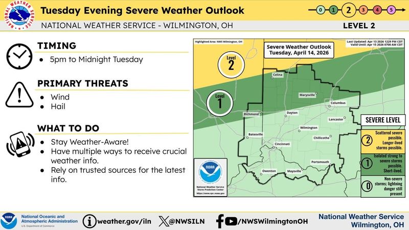
A severe thunderstorm warning in effect for Franklin, Delaware and Union counties as well as southern Morrow and Knox counties has expired, as has a severe thunderstorm watch for Madison County. Additional rain showers are expected Tuesday night for central Ohio, but the weather service said there is a “a low probability for widespread hazardous weather.”
The weather service said scattered thunderstorms are possible Wednesday afternoon into the evening in central Ohio. A few severe thunderstorms are possible with damaging wind gusts the primary threat.
What is a severe thunderstorm warning?
A Severe Thunderstorm Warning is issued when a storm is occurring or about to occur with winds of 58 mph or higher or hail one inch in diameter or larger, the National Weather Service says. These storms can also bring heavy rain and, in some cases, flooding or flash flooding.
Tips for staying safe during thunderstorms
Bring pets inside, and if time allows, make sure fences are secure to prevent pets from escaping or running away.
Once inside a shelter, stay away from windows and avoid using electrical equipment or plumbing.
Keep a battery-powered weather radio nearby in case of power loss.
Secure loose objects outside, as they can become dangerous during high winds.
Also, remember lightning can travel several miles from a storm, so hearing thunder means you’re within striking distance. The common advice from experts is “When thunder roars, go indoors.”
How to stay safe around lightning
If indoors:
Also, remember lightning can travel several miles from a storm, so hearing thunder means you’re within striking distance. The common advice from experts is “When thunder roars, go indoors.”
How to stay safe around lightning
If indoors:
Columbus forecast for the week
Tuesday night, April 14: A slight chance of showers and thunderstorms but with a chance of showers continuing into the evening. Partly cloudy, with a low around 66 degrees. Southwest winds around 14 mph, with gusts as high as 24 mph. Chance of precipitation is 20%.
Wednesday, April 15: A slight chance of showers, then a chance of showers and thunderstorms after 2 p.m. Partly sunny, with a high near 84 degrees. Southwest wind 13 to 16 mph. Chance of precipitation is 30%. New rainfall amounts of less than a tenth of an inch, except higher amounts possible in thunderstorms.
At night, a chance of showers and thunderstorms before 8 p.m., then a slight chance of showers between 8 p.m. and 2 a.m. on Thursday, April 16. Mostly cloudy, with a low around 65 degrees. Chance of precipitation is 30%. New precipitation amounts of less than a tenth of an inch, except higher amounts possible in thunderstorms.
Thursday, April 16: This appears to be the wettest day of the week. Showers likely and possibly a thunderstorm, mainly after 2 p.m. Mostly cloudy, with a high near 78. Chance of precipitation is 70%.
At night, showers likely and possibly a thunderstorm before 8 p.m., then a chance of showers and thunderstorms between 8 p.m. and 2 a.m. Friday, April 17. Mostly cloudy, with a low around 59 degrees. Chance of precipitation is 60%.
Friday, April 17: Mostly sunny, with a high near 82 degrees. At night, mostly cloudy, with a low around 63 degrees.
Saturday, April 18: Showers likely and possibly a thunderstorm. Mostly cloudy, with a high near 82 degrees. Breezy. Chance of precipitation is 60%. At night, showers also likely and possibly a thunderstorm. Mostly cloudy, with a low around 46 degrees. Chance of precipitation is 60%.
Reporter Shahid Meighan can be reached at smeighan@dispatch.com, at ShahidMeighan on X, and at shahidthereporter.dispatch.com on Bluesky
This article originally appeared on The Columbus Dispatch: Licking County tornado warning expires, severe T-storm warn until 10:15 pm.
Reporting by Shahid Meighan, Columbus Dispatch / The Columbus Dispatch
USA TODAY Network via Reuters Connect