
The hottest temperatures of the summer are headed toward Greater Akron.
And it will likely be as hot as a proverbial firecracker on the Fourth of July.

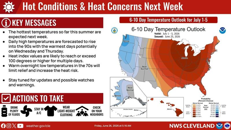
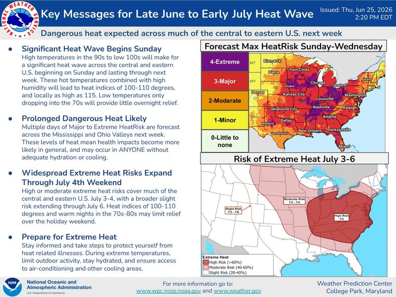
The National Weather Service warns a potentially dangerous heatwave will settle in over Northeast Ohio beginning next week.
Temperatures are expected to be in the 90s by Monday and slowly rise to nearly 100 degrees as the week progresses.
Aside from the heat, it is also expected to be humid too.
The high on Wednesday could hit 99 degrees.
The so-called real-feel temperatures are expected to exceed 100 degrees.
And to make matters worse, the weather service says there will be little, if any, relief at night as overnight temperatures will be in the 70s.
The string of hot and humid days could pose health risks for those working outdoors or those without access to air conditioning.
The weather service says watches and warnings will be likely as a result of the extreme heat.
Will the heatwave set a record?
The Fourth of July heatwave could break weather records that are some 100 years old.
The average high for early July in Greater Akron is 84 degrees with overnight lows of 63 degrees.
Temperatures in the forecast are way above the norm.
The forecast high on Tuesday, June 30, is 98 and that would break the record of 96 degrees set in 1913.
The forecast high on Wednesday, July 1, is 99 degrees. The record set in 1931 is 97 degrees.
The anticipated high on Thursday, July 2, is 98 degrees and that would tie the record set in 1931.
The warmest July 4 on record is 99 degrees set in 1911.
Greater Akron Weather Radar
Greater Akron Weather Forecast
Friday: Patchy fog before 10 a.m. Otherwise, mostly cloudy, with a high near 78. Calm wind becoming west around 5 mph in the afternoon.
Friday night: Showers likely, mainly after midnight. Cloudy, with a low around 64. Calm wind. Chance of precipitation is 70%. New precipitation amounts between a tenth and quarter of an inch possible.
Saturday: A chance of showers, with thunderstorms also possible after noon. Cloudy, then gradually becoming mostly sunny, with a high near 80. East wind around 6 mph. Chance of precipitation is 40%. New rainfall amounts between a tenth and quarter of an inch, except higher amounts possible in thunderstorms.
Saturday night: Partly cloudy, with a low around 61. North wind around 5 mph becoming calm in the evening.
Sunday: Mostly sunny, with a high near 86. Light northeast wind.
Sunday night: Mostly clear, with a low around 64.
Monday: Mostly sunny, with a high near 92.
Monday night: Mostly clear, with a low around 71.
Tuesday: Sunny and hot, with a high near 98.
Tuesday night: Mostly clear, with a low around 74.
Wednesday: Sunny and hot, with a high near 99.
Wednesday night: Mostly clear, with a low around 74.
Thursday: Sunny and hot, with a high near 98.
Akron weather hourly
Need to know weather conditions by the hour? Make sure to check out our weather page here.
This article originally appeared on Akron Beacon Journal: Dangerous heatwave to hit Greater Akron next week. How hot will it get?
Reporting by Craig Webb, Akron Beacon Journal / Akron Beacon Journal
USA TODAY Network via Reuters Connect
By Craig Webb, Akron Beacon Journal | USA TODAY Network