If you think the Canton area had a cold winter, you’re right.

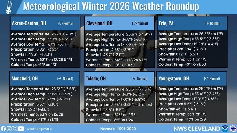
The National Weather Service says it was colder than normal with an average temperature of 25.7 degrees − 4.7 degrees below the norm, based on data gathered at the Akron-Canton Airport.
The average high temperature was 33.7 degrees − 4.3 degrees below the typical highs.
The average low temperature for this past winter was 17.7 degrees − 5.1 degrees below average.
It was snowier than normal.
Some 44.3 inches of snow fell − 10 inches above normal.
The warmest day was 62 degrees on Dec. 28 and Jan. 9.
The coldest day was 9 degrees below zero on Jan. 31.
What is meteorological winter?
Astrological winter starts around Dec. 21 and ends with the vernal equinox, which falls on March 20 this year.
Meteorologists prefer to define winter as the months of December through February as it aligns with the coldest months of the year.
Proponents argue it gives a consistent time span to compare records as opposed to the mid-month dates of the astrological winter.
Canton-area weather forecast
A warmup is in the forecast for the Canton area. Spring-like showers and rumbles of thunder are in the forecast. A high near 68 is expected on March 6, and 71, on March 7.
The forecast:
Today: Heavy dense fog until 10 a.m. Showers, with thunderstorms also possible after 4 p.m. Patchy dense fog between 4 p.m. and 5 p.m. High near 61. South wind 6 to 10 mph. Chance of precipitation is 100%. New rainfall amounts between a half and three quarters of an inch possible. At night, showers and thunderstorms likely before 9 p.m, then a chance of showers between 9 p.m. and 11 p.m. Cloudy, a low around 51, southwest wind at 3 to 8 mph and a 70% chance of precipitation. New precipitation amounts between a 10th and a quarter of an inch, with higher amounts possible in thunderstorms.
March 6: A slight chance of showers before 1 p.m. Widespread dense fog before 7 a.m. Mostly cloudy with a high near 68, a light south wind increasing to 5 to 9 mph in the morning and a 20% chance of precipitation. At night, a slight chance of showers after 1 a.m., mostly cloudy, a low around 61, a south wind at 8 to 13 mph with gusts as high as 24 mph, and a 20% chance of precipitation.
March 7: Showers likely before 1 p.m., then showers and possibly a thunderstorm between 1 p.m. and 4 p.m., then showers after 4 p.m. High near 71. South wind at 14 to 18 mph with gusts as high as 31 mph. Chance of precipitation is 100%. New rainfall amounts between a 10th and a quarter of an inch, except higher amounts possible in thunderstorms. At night, a chance of showers before 1 a.m., mostly cloudy, a low around 41 and a 50% chance of precipitation is 50%. New precipitation amounts of less than a 10th of an inch possible.
March 8: Mostly sunny with a high near 56. At night, mostly clear with a low around 42.
March 9: Sunny, with a high near 67. At night, partly cloudy with a low around 52.
March 10: A chance of rain. Mostly cloudy with a high near 67. Chance of precipitation is 50%. At night, rain likely, mostly cloudy, low around 57 and 60% chance of precipitation.
March 11: Rain. High near 69. Breezy. Chance of precipitation is 80%.
The Akron Beacon Journal contributed to this story.
This article originally appeared on The Repository: Canton area’s cold, snowy winter gives way to spring warmth
Reporting by Canton Repository / The Repository
USA TODAY Network via Reuters Connect