After dealing with rain and stormy weather last week, Canton is still not in the clear.
The National Weather Service is forecasting rain off and on throughout the week.

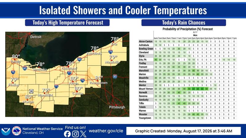
Its says there is a chance of rain and thunderstorms between noon and 4 p.m. today. The high will be 80 and the low will be around 61. There is a 40% of precipitation. The evening will be partly cloudy.
Weather forecast for the Canton region
Tuesday: Mostly sunny, with a high near 80. Calm wind becoming west around 6 mph. The evening will be partly cloudy, with a low around 62.
Wednesday: A chance of showers and thunderstorms between 11 a.m. and 2 p.m., that may continue after 2 p.m. The day will be partly sunny, with a high near 79. At night, showers likely and possibly a thunderstorm before 8 p.m. It will be mostly cloudy, with a low around 61.
Thursday: Partly sunny, with a high near 78. Later in the day it’s expected to be partly cloudy, with a low around 58.
Friday: Mostly sunny, with a high near 78. Later on, partly cloudy, with a low around 59.
Saturday: Mostly sunny, with a high near 80 and chance of showers. In the evening, partly cloudy, with a low around 60. Chance of precipitation is 30%.
Sunday: A chance of showers. Partly sunny, with a high near 77. Chance of precipitation is 30%.
This article originally appeared on The Repository: Canton area weather: Rain and thunderstorms sticking around this week
Reporting by Aaron Hughes, Canton Repository / The Repository
USA TODAY Network via Reuters Connect
By Aaron Hughes, Canton Repository | USA TODAY Network