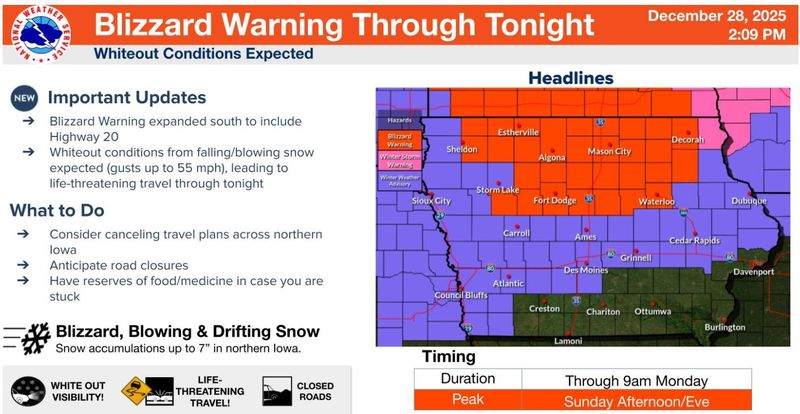
A blizzard roared through northern Iowa, bringing travel to a standstill in all but a few counties in northern Iowa, and a National Weather Service warning is set to continue overnight.
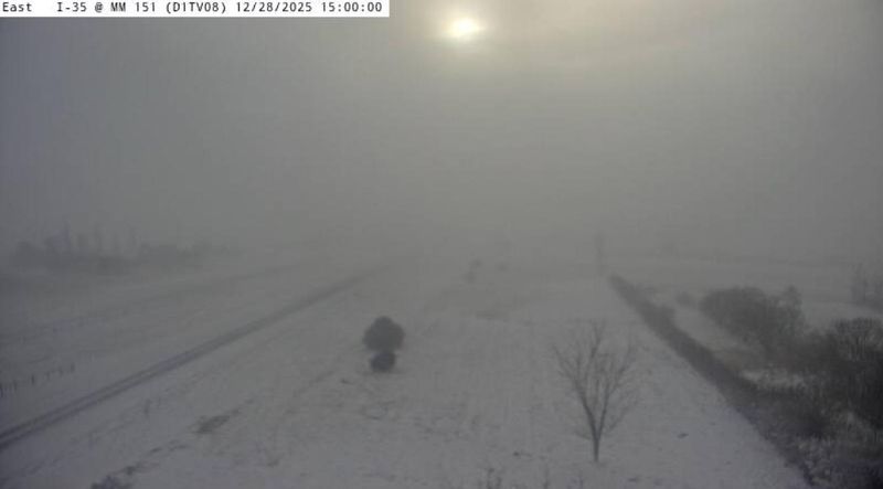
The area include more than 200 miles of Interstate 35 from Ames to the Minnesota border, where the roadway was blocked in both directions Sunday, Dec. 28, by blowing snow. The Minnesota State Patrol said the highway also was blocked in the southern part of that state,

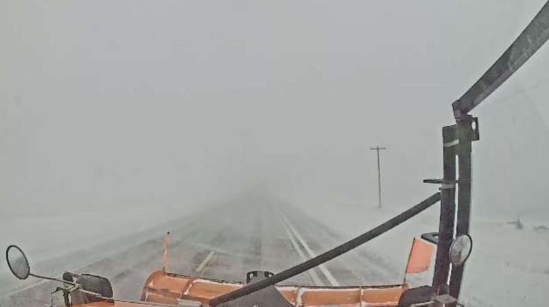
U.S 18 was closed indefinitely east of Clear Lake with what the O’Brien County sheriff reported on Facebook were accidents in both directions. The Iowa State Patrol said that across the state as of Sunday evening, it had investigated 31 crashes, one fatal and eight with injuries. It provided no details..
In addition to the 30 Iowa counties for which the weather service issued a blizzard warning, another county remains under a winter storm warning and a winter weather advisory is in effect south to the Interstate 80 and 29 corridors. The area includes the Des Moines and Ames metros, where a fast-developing snow squall brought a burst of snow that prompted the weather service to issue a warning of possible whiteout conditions.
The squall moved across the state, hitting Newton, Marshalltown, Grinnell and Waterloo before dissipating. Another snow squall hit Monona, Harrison and Shelby counties in western Iowa.
The blizzard warning is in effect through 9 a.m. Monday. It covers Blackhawk, Bremer, Butler, Calhoun, Cerro Gordo, Chickasaw, Clay, Dickinson, Emmet, Fayette, Floyd, Franklin, Grundy, Hamilton, Hancock, Hardin, Howard, Humboldt, Kossuth, Mitchell, O’Brien, Osceola, Palo Alto, Pocahontas, Sac, Webster, Winnebago, Winneshiek, Worth and Wright counties.
The winter storm warning, covering Allamakee County in extreme northeast Iowa, also has been extended to 9 a.m. The winter weather advisory for other Iowa counties is slated to expire at 6 a.m. in central Iowa south of Interstate 80. It will continue until 9 a.m. north of I-80, including Ames, and in the eastern part of the advisory area, including Iowa City.
The weather service said the counties in the blizzard warning area could expect 2 to 7 inches of snow with extremely high and gusting northwest winds, creating potential whiteout conditions. Estherville Municipal Airport reported a gust of 62 mph.
The winter storm warning covers an area extending into Wisconsin that could see 5 to 7 inches of snow by the time the storm ends. It also was experiencing high winds.
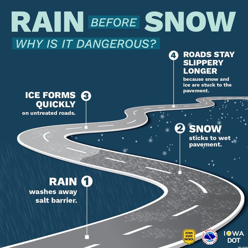
Rain preceded the snow in some areas, including central Iowa, and posed the potential for especially hazardous driving conditions as temperatures across the state quickly fell. The Iowa State Patrol and Iowa Department of Transportation warned untreated roads could quickly become coated with ice.
“Anticipate challenging to dangerous travel today and tonight, with travel discouraged in northern Iowa,” the weather service said.
Snow and high winds expected in central and eastern Iowa
In the Des Moines and Iowa City metros and other areas farther south, snow accumulation was expected to range from less than half an inch to an inch or more. Winds there also were high, with Des Moines International Airport reporting a gust of 53 mph.
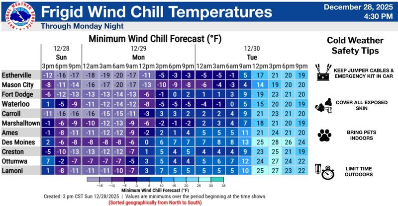
Temperatures on Sunday in central and eastern Iowa started the day in the 40s but had dropped to a low of about 10 degrees by 8 p.m. Windchill made them feel like -8, the weather service said.
Father north, with ambient temperatures well below zero, windchill was expected to make them feel as low as -20 degrees.
Cold and wind to linger as week begins
The weather service said sunshine should return Monday, but with a high of 20 in central Iowa and continued wind until the evening. The low is expected to be a blustery 13 degrees.
Tuesday could bring a bit of a warmup, with a high of 37 and a low of 26 in the evening as clouds move in.
Wednesday’s forecast calls for cloudy skies with a high of 34 and a low of 16, and New Year’s Day will be partly sunny and colder, with a high of 26 and a low around 15.
Farther east, beyond Iowa’s borders, conditions could be more extreme as the week begins, with a blizzard warning issued for parts of the Great Lakes region Monday, the weather service said.
Polk County to activate extreme temperature plan
In response to Sunday’s forecast, Polk County Emergency Management activated its extreme temperature plan at 4 p.m. Sunday. The county activates the plan when temperatures reach certain thresholds: 10 degrees with wind chill for three or more days, 5 degrees with wind chill for two or more days or 0 degrees or less with wind chill for at least one day.
The plan includes weather amnesty at Central Iowa Shelter and Services, temporarily removing limitations on shelter nights; the opening of warming centers across the metro; and free transportation to the centers via DART bus service.
Where are warming shelters in Des Moines and central Iowa?
Warming centers in Des Moines include:
A full list of available warming centers can be found on the Polk County website, polkcountyiowa.gov. The county recommends calling ahead to check for availability. See which centers are along DART bus routes on the DART website, ridedart.com.
(This story has been edited to add new information.)
Kyle Werner is the Breaking News & Public Safety Reporter for the Register. Reach him at kwerner@registermedia.com
This article originally appeared on Des Moines Register: Blizzard engulfs most of northern Iowa, closing I-35
Reporting by Kyle Werner, Des Moines Register / Des Moines Register
USA TODAY Network via Reuters Connect