Iowa is going to see some welcome relief over the next two days as a storm front moves into the state.
While residents in Des Moines woke up to hazy skies and some slight showers on Tuesday, Aug. 4, the National Weather Service in Des Moines is forecasting the bulk of central Iowa’s rain will come on Tuesday night.

Here are the latest Iowa rainfall totals and a look at the upcoming forecast.
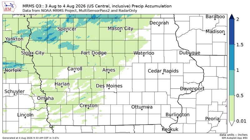
How much rainfall did Des Moines get?
Official data from the Iowa Environmental Mesonet showed very little rainfall in Des Moines between Aug. 3 and 4, listing the rainfall total as 0.02 inches as of 10 a.m. Aug. 4. Ankeny had a little more, recording 0.24 inches.
In Ames, however, official gauges show that 0.12 inches of rain fell overnight.
Which cities saw the most rain?
The cities that saw the most rain between 9 p.m. Aug. 3 and 9 a.m. Aug. 4 are:
That’s some welcome relief for northwest Iowa. Before this spate of rain, Iowa was the driest it had been all summer, with extreme drought conditions developing in a small pocket along the Missouri River.
What is the forecast for Des Moines?
There’s more rain coming. On Tuesday, Aug. 4, there’s a 50% chance of showers and thunderstorms after 2 p.m. Although there’s not a lot of rain for the rest of the day. The NWS projects Des Moines will see less than a tenth of an inch, unless thunderstorms happen.
More rain will fall on Tuesday night, with 1 to 2 inches of rain possible after midnight.
Showers and thunderstorms will taper off slightly heading into Wednesday, August 5, before skies clear up Thursday morning.
Des Moines weather radar
Lucia Cheng is a service and trending reporter at the Des Moines Register. Contact her at lcheng@gannett.com or 515-284-8132.
This article originally appeared on Des Moines Register: Parts of Iowa had more than 1 inch of rain. Is it going to rain today?
Reporting by Lucia Cheng, Des Moines Register / Des Moines Register
USA TODAY Network via Reuters Connect

By Lucia Cheng, Des Moines Register | USA TODAY Network