The first of several stormy days in Iowa brought more than an inch of rain to some parts of the state, while triggering severe thunderstorm warnings.
Storms along Iowa’s northern and southern borders triggered severe thunderstorm warnings on May 15, with large hail and damaging winds.

Storms in Iowa are expected to continue daily through Tuesday, May 19.
Here’s a look at rainfall totals and the latest National Weather Service severe weather outlook.
How much rain did we get last night?
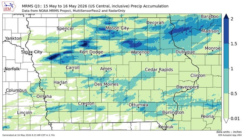
Here are the areas that saw the highest rainfall totals in Iowa over a 24-hour period as of 8 a.m. Saturday, May 16, according to the Iowa Environmental Mesonet and Community Collaborative Rain, Hail & Snow netowrk:
How much rain did Des Moines get?
The airport in Des Moines recorded 0.3 inches of rain as of 8 a.m. Saturday, May 16, according to the Iowa Environmental Mesonet.
Other rainfall reports to the CoCoRaHS ranged from 0.89 inches in Polk City to 0.29 inches in Urbandale.
Ankeny reported 0.53 inches and farther north, Ames reported 0.41 inches.
When is the next chance for storms in Iowa?
The severe weather threat continues through the weekend.
Much of western and central Iowa is at a slight (level 2 of 5) risk of severe weather on Saturday, May 16. Storms are expected after 3 p.m., continuing into Sunday morning.
The biggest risk for storms on Saturday will be wind gusts up to 75 mph, hail up to 2 inches in diameter, and heavy rain. A tornado are two is possible in southwest Iowa, according to the weather service.
A similar risk exists on Sunday with new storms expected to develop after 7 p.m. and continuing through Monday morning. The strongest tornado risk is in northwestern Iowa with the late Sunday storms.
A third wave of storms are expected Monday evening, bringing an enhanced (level 3 of 5) risk of severe weather to much of southwest and central Iowa.
Iowa Doppler radar
Track any incoming storms with the latest Des Moines radar from the National Weather Service:
Are there weather warnings in Iowa?
Check the map below for the latest watches and warnings in Iowa:
Get weather updates via text
Brian Smith is an audience strategist and senior editor at the Des Moines Register. He oversees breaking, service and trending news, including weather. Contact him at bsmith@dmreg.com or 515-284-8214.
This article originally appeared on Des Moines Register: How much rain did we get? See totals before more storms in Iowa
Reporting by Brian Smith, Des Moines Register / Des Moines Register
USA TODAY Network via Reuters Connect