EVANSVILLE – The major winter storm forecasters have been warning about for days will arrive. It’ll just be a little late.
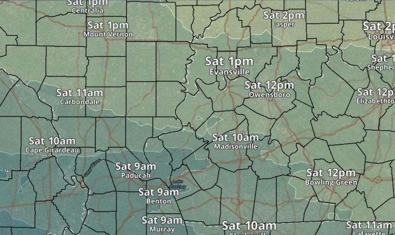
Originally slated to sweep across the area starting midnight Friday, snow won’t start to accumulate in the Evansville area until around 1 p.m., the Paducah, Kentucky office of the National Weather Service said in its latest bulletin Saturday morning.

What’s the timeline for snow in Evansville?
“Light to moderate snow” will blanket the entire Tri-State by 2 p.m., the NWS said. Then there could be a “brief lull” later in the day before a heavier band arrives later in the afternoon and early evening.
As much as 6 inches of snow could be piled on the ground by midnight. The storm will continue to churn all through the night.
Evansville will have an 80%-100% chance of precipitation all the way from noon Saturday to 9 a.m. Sunday. A 70% chance of snow will linger until around 6 p.m. before the stuff finally tapers off.
How much snow will Evansville and the Tri-State get?
Broadly, the NWS expects 8-12 inches to encase everywhere from the bootheel of Missouri to Southwestern Indiana.
Evansville could see the high end of that. As of Saturday morning, forecasters predicted 9 to 13 inches of snow for the city and Vanderburgh County.
Large portions of Henderson County, Kentucky, could get 9-13 inches as well, while other parts could see 7-12 inches.
Is there any chance of sleet or freezing rain?
Not for Evansville as of now. Areas of southwestern Kentucky could see a mix of both, however. It would be the northern edge of a massive ice storm that is expected to pound the southern U.S. all the way from Central Texas to the Carolinas.
‘Major disruptions’ expected
The foot-or-so of snow will create “dangerous or impossible” driving conditions in the Tri-State. Both the NWS and Evansville Mayor Stephanie Terry have urged residents to avoid any unnecessary travel.
Crews have already pretreated miles of city and county roads. Workers on Friday were continuing to remove debris from the more than 1,000 drains and inlets that comprise Evansville’s water and sewer system. Thousands of pounds of pretreated salt are on hand to de-ice streets and highways.
Terry urged residents to inspect drains in their neighborhoods and to clear debris “if it’s safe to do so.”
The Indiana Department of Transportation will handle the treating and clearing of all state roads and U.S. routes. That includes the Lloyd Expressway, U.S. 41, Interstate 69 and others.
Evansville crews will largely clear main roadways along pre-determined “snow routes.”
This article originally appeared on Evansville Courier & Press: Here’s when snow could start accumulating in Evansville, Tri-State
Reporting by Jon Webb, Evansville Courier & Press / Evansville Courier & Press
USA TODAY Network via Reuters Connect