

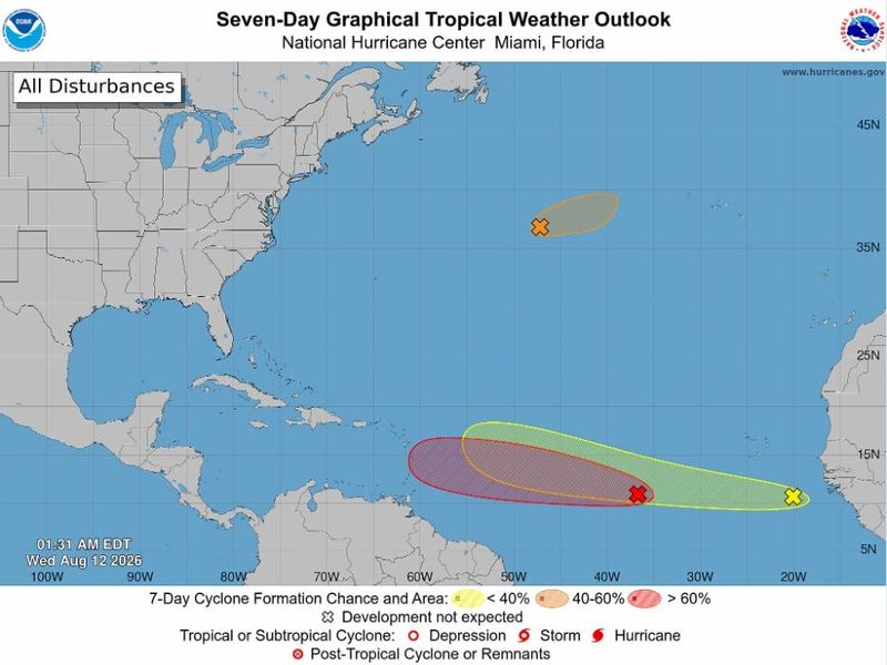
Tropical waves lurching off Africa are clearing the way for each successor with one facing a dramatic fizzle, another expected to reach the Caribbean as a soggy tropical cyclone and a newcomer wildcard with a muddled future.
At the same time, an oddball area of stretched low pressure more than 1,000 miles east-northeast of Bermuda may steal the name Cristobal before zipping headlong into storm killing cold water.

“Busy for early August!” is what the National Hurricane Center posted on social media late Tuesday, Aug. 12.
There are no current threats to the U.S. but experts urge people to keep an eye on forecasts.
“Certainly things have come to life,” said lead AccuWeather hurricane forecaster Alex DaSilva. “We don’t want people to sleep on this season and we’ve been saying that from the beginning.”
Meteorologists watched slightly befuddled early in the week as an anticipated merger between a wave leaving Africa and an area of low pressure over the tropical Atlantic never happened.
Instead, the whizbang forecast model Google DeepMind had already sniffed out a new spot to watch, also leaving Africa, that the NHC marked Tuesday night with a 20% chance of development over seven days.
By Wednesday morning, the newly marked system was up to a 30% chance.
“The first wave we were tracking croaked going into the Lesser Antilles, the second one we have a high risk on, but it doesn’t have spin with it, and the new one, we have a medium risk on because it’s pretty robust,” DaSilva said. “The first one that croaked primed the pump for the second one and the second one primed the pump for the one after.”
Priming the pump in the main runway between Africa and the Caribbean right now means pushing aside Saharan dust and dry air that can inhibit storm formation.
Rainfall would be beneficial for parched Caribbean islands
For the near future, it’s Invest 92L that the Lesser Antilles should keep an eye on. Forecast models have a faster, weaker system skirting under the Bermuda High and reaching the islands closer to the weekend.
DaSilva said it’s moving toward stronger wind shear and that may deter development into a tropical storm, but the islands are starved for rain so a tropical drenching isn’t a bad thing.
The Federal Emergency Management Agency (FEMA) said it’s providing water trailers to Puerto Rico as water shortages and rationing grip the island, according to ABC News.
“We are not expecting any major impacts to the islands and they are desperately needing this tropical wave because of the drought,” Da Silva said. “They will be welcoming the rain, and once it gets to the island, that could be the end of it because of the wind shear.”
Colorado State University hurricane expert Phil Klotzbach posted on social media that wind shear in the main development region between Africa and the Caribbean is the strongest on record, “recently pulling ahead of 2015.”
When is the next El Niño forecast update?
That was the year of the strong “Godzilla” El Niño. This year’s El Niño is expected to break records with an updated forecast scheduled to be released Aug. 13 by the Climate Prediction Center.
The ambitious waves this week come just days after Colorado State University and the National Oceanic and Atmospheric Administration updated their 2026 seasonal hurricane forecasts.
Both maintained predictions for a much below or below average season as a burgeoning El Niño deepens in the Pacific.
Kimberly Miller is a journalist for the USA TODAY NETWORK FLORIDA. She covers weather, the environment and critters as the Embracing Florida reporter. If you have news tips, please send them to kmiller@pbpost.com. You can get all of Florida’s best content directly in your inbox each weekday by signing up for the free newsletter, Florida TODAY, at palmbeachpost.com/newsletters.
This article originally appeared on Palm Beach Post: ‘Things have come to life’ in tropics as hurricane center watches new area
Reporting by Kimberly Miller, USA TODAY NETWORK – Florida / Palm Beach Post
USA TODAY Network via Reuters Connect
By Kimberly Miller, USA TODAY NETWORK – Florida | USA TODAY Network
