The National Hurricane Center has classified a tropical wave in the central Atlantic as Invest 96L.
Forecasters said the system could become a tropical depression over the weekend as it moves across the Atlantic.

➤ Track all active storms
➤ Weather alerts via text: Sign up to get updates about current storms and weather events by location
Historically, the fifth-named storm in the Atlantic develops Aug. 22, with the first hurricane developing Aug. 11. The last three storms in the Atlantic have formed ahead of historical averages.
Invest 96L is one of three systems being tracked by the National Hurricane Center.
Tropical Storm Dexter in the northern Atlantic is expected to reach hurricane strength within the next 24 hours.
Chances for development have decreased for a system off the southeastern coast of the U.S.
The next named storms of the 2025 Atlantic hurricane season will be Erin and Fernand.
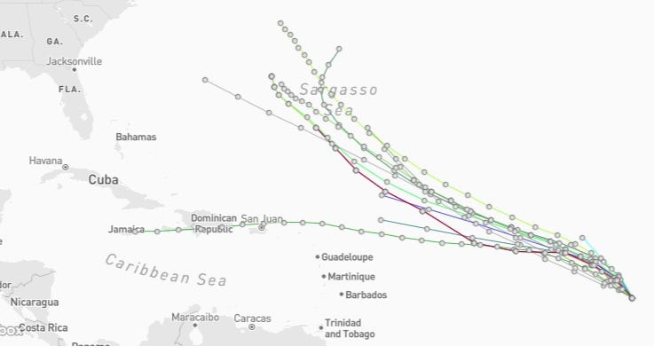
Spaghetti models for Invest 96L. See expected path
Special note about spaghetti models: Spaghetti model illustrations include an array of forecast tools and models, and not all are created equal. The Hurricane Center uses only the top four or five highest performing models to help make its forecasts.
➤ Track Invest 96L
What is an invest?
Short for investigation, the National Hurricane Center uses the term invest for areas of low pressure it is monitoring for potential development into a tropical depression or storm.
Invests are not tropical depressions or tropical storms. They’re usually clusters of showers and thunderstorms, and just because they’ve been designated as an invest does not guarantee they’ll strengthen into a tropical storm or hurricane.
Invests run from 90 to 99, followed by a letter: L for the Atlantic basin and E for those in the eastern Pacific. After 99, it starts over again and the next invest would be 90.
Once something has been designated as an invest, specialized data sets and computer models can begin, including scheduling Hurricane Hunter aircraft missions and running spaghetti models.
Track active Atlantic storms and disturbances
This auto-updated graphic shows a map of all active storms in the Atlantic basin.
Can’t see the graphic? Open in a new browser.
➤ National Hurricane Center tracking Invest 96L. See the latest forecast
See NWS weather radar of storms across Florida, southeastern US
Latest weather watches and warnings issued in Florida
Excessive rainfall forecast across Florida
Stay informed. Get weather alerts via text
What’s next?
We will update our tropical weather coverage daily.
Download your local site’s app to ensure you’re always connected to the news. And look for our special subscription offers here.
This article originally appeared on Florida Times-Union: See latest spaghetti models, tracker map for Invest 96L
Reporting by Cheryl McCloud, USA TODAY NETWORK – Florida / Florida Times-Union
USA TODAY Network via Reuters Connect