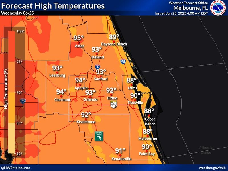
There’s no break in the oppressive heat wave expected on Wednesday, June 25, according to the latest forecast from the National Weather Service, although the chances for showers that could ease the scorching temperatures increase later this week.
Even so, hot and humid conditions will continue into early next week, with peak heat index levels of 100-105 degrees, according to the National Weather Service in Melbourne.

“We expecting to see a very similar weather pattern today and we’re not really anticipating too much in the way of rainfall, unfortunately,” said Megan Tollefsen, meteorologist with the National Weather Service in Melbourne.
“There seems to be a bit of turn tomorrow, with more moisture across area on Thursday and Friday and into the weekend, as we return to higher rain chances in the area.”
In Daytona Beach area, heat not expected to reach record highs
Although hot, temperatures aren’t expected to reach record highs, Tollefsen said.
“It won’t be quite that high,” she said. “In the Daytona Beach area, we’re looking at upper 80s to low 90s for remainder of week and into the weekend. Looking at the daily records, those temperatures are in the upper 90s and we’re not forecasting that at this time.”
Outdoors in Daytona Beach or nearby? Take precautions
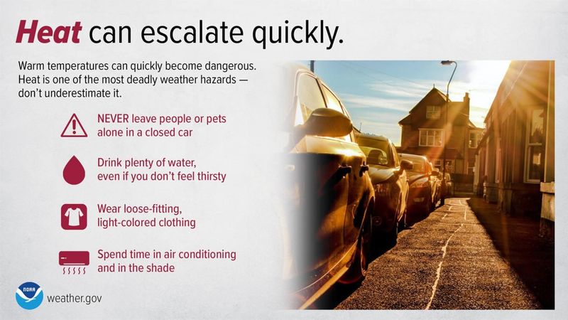
If you are outside, folks in Volusia and Flagler counties are advised to be sure to drink plenty of water, take frequent breaks in the shade and/or air conditioning, and wear light clothing.
That’s particularly important for visitors to the area, who might not be accustomed to Florida’s summer heat, Tollefsen said.
“We’re urging people to make sure to stay well hydrated, to take frequent breaks in the air-conditioning and practice heat safety. Even though it’s not record-breaking heat, it’s still warm, and it feels warmer to those not familiar with the Florida heat.”
At area beaches, there’s a moderate risk of rip currents at all area beaches on Wednesday, June 25, and at least into Thursday, June 26.
Storm chances in Volusia, Flagler expected to increase
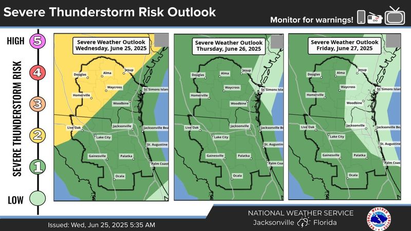
Looking ahead, increasing shower and storm coverage is expected through late week, according to the NWS.
Some storms may be stronger, with gusty winds each afternoon. Portions of east Central Florida are outlined at a marginal risk for severe weather on Wednesday and Thursday, June 25 and 26.
If you are outdoors, remember that lightning can strike beyond 10 miles from the core of a storm, so it’s advised to remember that “When thunder roars, go indoors!”
In Flagler, temperatures could reach mid-90s
In Flagler County, highs are expected to soar to the mid and upper 90s at inland locations by afternoon on Wednesday, June 25, with peak heat index values around 105 degrees, according to the National Weather Service in Jacksonville.
Daytona Beach weather radar
Extended forecast for Daytona Beach
Wednesday, June 25: A 20% chance of showers and thunderstorms after noon. Mostly sunny, with a high near 87 and nighttime low around 74. Light and variable wind becoming east 5 to 10 mph in the morning.
Thursday, June 26: A 60% chance of showers, most likely after 2 p.m. Otherwise, sunny, with a high near 88 and nighttime low around 73. Light south wind becoming east southeast 5 to 10 mph in the morning. New rainfall amounts of less than a tenth of an inch, except higher amounts possible in thunderstorms.
Friday, June 27: A 70% chance of precipitation, most likely after 2 p.m. Otherwise, mostly sunny, with a high near 89 and nighttime low around 73. Light and variable wind becoming east southeast 5 to 10 mph in the morning.
Saturday, June 28: An 80% chance of showers or thunderstorms. High near 89, with nighttime low around 72. Southwest wind 5 to 10 mph becoming southeast in the afternoon.
Sunday, June 29: A 60% chance of precipitation. Partly sunny, with a high near 88 and nighttime low around 74. Southwest wind 5 to 10 mph becoming southeast in the afternoon.
Extended forecast for Palm Coast
Wednesday, June 25: Mostly sunny, with a high near 87 and nighttime low around 74. Light and variable wind becoming east 6 to 11 mph in the morning. Winds could gust as high as 17 mph.
Thursday, June 26: A 30% chance of showers and thunderstorms, mainly after 2 p.m. Sunny, with a high near 85 and nighttime low around 74. Southeast wind 5 to 11 mph, with gusts as high as 17 mph.
Friday, June 27: An 80% chance of showers and thunderstorms. High near 85, with nighttime low around 73. Light and variable wind becoming southeast 5 to 10 mph in the afternoon.
Saturday, June 28: An 80% chance of precipitation. High near 85, with nighttime low around 74.
Sunday, June 29: An 80% chance of precipitation. High near 84, with nighttime low around 74.
This article originally appeared on The Daytona Beach News-Journal: Scorching temps for Daytona, Palm Coast continue, but when will rain arrive?
Reporting by Jim Abbott, Daytona Beach News-Journal / The Daytona Beach News-Journal
USA TODAY Network via Reuters Connect