Heavy rain. Thunderstorms. Flash flood risks.
That’s the forecast for many areas across Florida over the Fourth of July holiday weekend as a system of low pressure develops either near Florida or in the Atlantic off the southeastern United States.

➤ Track all active storms
➤ Weather alerts via text: Sign up to get updates about current storms and weather events by location
As of Thursday, July 3, the system has a medium chance of developing into a tropical or subtropical depression over the holiday weekend or early next week, according to the National Hurricane Center.
Regardless of development, widespread rain and thunderstorms are expected to continue for Northeast Florida and the peninsula into early next week, the Florida Department of Emergency Management said.
If the right conditions are there, they could “potentially ignite tropical development,” said Alex DaSilva, AccuWeather lead hurricane expert in an email Monday, June 30.
“This is fairly common this time of the year, June and July, that you get old frontal boundaries kind of coming off the southeast coast and into the Gulf and stalling. And then you get a little area of spin to develop along that decaying cold front, and then that’s how you get these usually fairly short-lived tropical systems early in the season.
“They tend to be a little on the weaker side, but they can bring a lot of rain, especially if they do develop. I think that’s what we might end up seeing here.”
National Hurricane Center tracking area of disturbance
An area of low pressure is forecast to develop along a weakening frontal boundary near Florida or the Atlantic coast of the southeastern United States on Friday or Saturday.
Environmental conditions appear only marginally conducive for some slow development, but a tropical or subtropical depression could form in this region over the weekend or early next week while the system drifts northward or northeastward.
Regardless of development, heavy rainfall is possible across portions of the southeast U.S.,particularly across the west-central Florida coast.
An Air Force Reserve Hurricane Hunter aircraft is scheduled to investigate the system on the Fourth of July, if necessary.
Could a tropical storm or tropical depression affect your Florida Fourth of July plans?
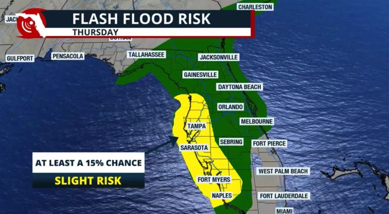
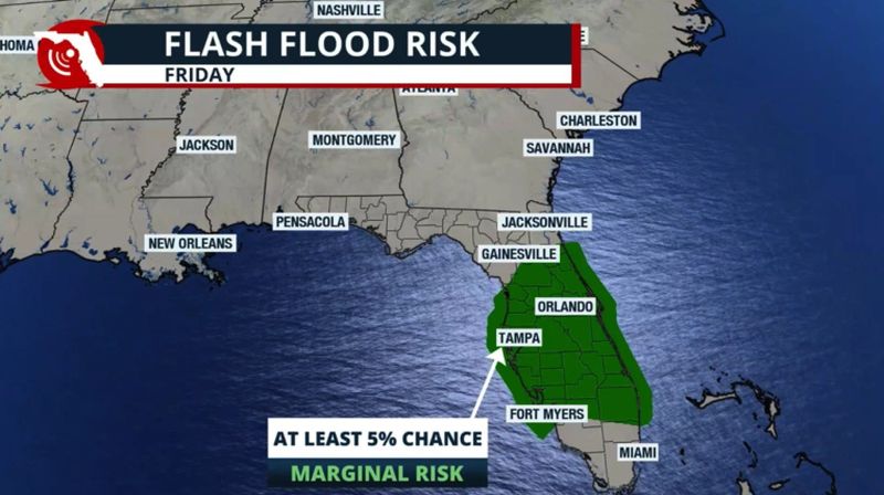
“Regardless of development, an increase in shower and thunderstorm activity can be expected along Northeast Florida and the Florida Peninsula during the next five days (through the holiday weekend),” the Florida Department of Emergency Management said.
“An increase in flooding potential can be expected along the Florida West Coast and for several urban, low-lying/poor drainage areas through the weekend.”
“The soonest this system could develop is on Saturday (July 5) afternoon,” the Florida Public Radio Emergency Network said.
“The American GFS model shows the system developing near northeast Florida, but this is being extremely generous.
“On the other hand, the European model shows the system barely developing late on Sunday but not surviving for too long. A cold front is expected to exit the Great Lakes early next week, and ahead of it, a trough may either push this system away or absorb it.”
“Regardless of tropical development, local flooding rain risk remains into the weekend. Daily afternoon and evening thunderstorms are expected. … with a potential for flash flooding, the National Weather Service Jacksonville posted on X.
“If tropical system does eventually develop east of Florida or south of the Carolinas, steering currents are light, so it could well linger near the Gulf Stream into next week,” said Dr. Ryan Truchelut, chief meteorologist with WeatherTiger. “Dry air and some northerly wind shear would most likely keep anything that develops weak.”
Truchelut is a Florida meteorologist who works with the USA TODAY Network.
“For Florida’s sake, it would be better for it to happen east of Florida because then it would likely just get pushed out to sea.”
Weather alerts issued in Florida
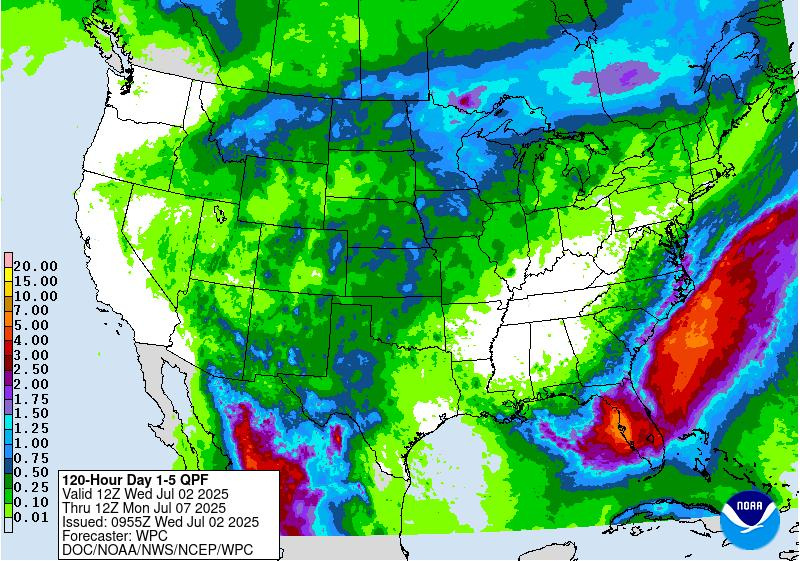
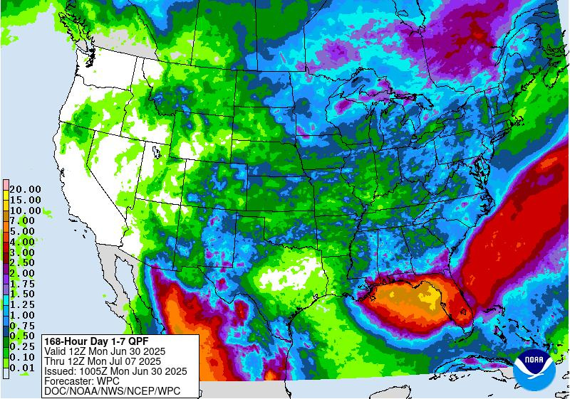
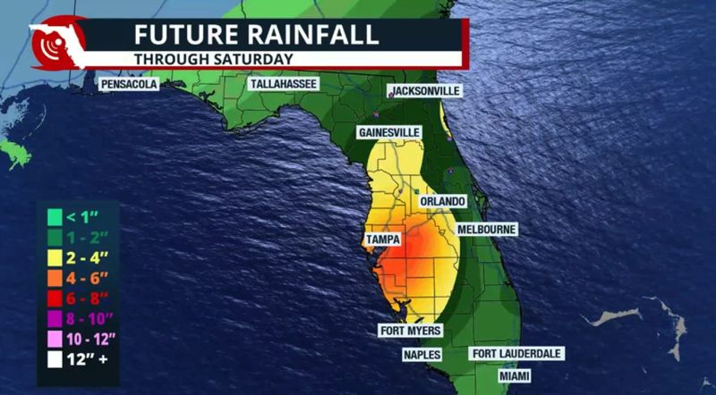
How much rain is in Florida’s forecast over Fourth of July holiday weekend?
Here’s what Florida Public Radio Emergency Network is predicting by region for the Fourth of July weekend:
Fourth of July holiday forecast for Florida Panhandle
“The Panhandle is expected to remain dry for the July 4th holiday. There is a slight chance of scattered showers and isolated storms, but this trend is expected to continue downward into Friday evening. Saturday will also stay with a low chance for showers, but storm activity is likely to pick up again by late this weekend.”
Fourth of July holiday forecast for North Florida
“North Florida is likely to experience isolated flash floods through early this weekend as the front stalls and any future tropical energy tries to spin nearby.
“There could be some areas with up to 4 inches of rain, especially areas south of Jacksonville.”
Fourth of July holiday forecast for Florida’s West Coast
“Along the west-central coast, there is a slight chance of flash flooding. From Cape Coral through Tampa and its surrounding areas, there could be between 2 and 4 inches of rain, with some isolated areas potentially receiving up to 6 inches.
“It’s been a rainy Wednesday, and the ground is already well saturated. Storms are expected to persist through the evening on Friday.”
Fourth of July holiday forecast for Central Florida, including east coast and southwest areas
“The Orlando area, including Melbourne, is expected to receive between 1 and 2 inches of rain through Friday night. Some isolated areas could receive up to 4 inches of rain, potentially resulting in minor flooding in certain regions.
“The weekend will remain unsettled across Central and Southwest Florida with likely showers in the morning and afternoon thunderstorms.”
Fourth of July holiday forecast for South Florida
“One to 3 inches of rain are possible through Friday night across South Florida, especially along metro areas. This is beneficial rain, but keep in mind that with the ground so dry, areas that receive high amounts in a short period may struggle to drain, and flooding may develop.
“This is especially significant in Palm Beach and Broward counties, where a severe and patchy area of extreme drought.”
“The weekend may have less shower and thunderstorm activity, as the low is expected to be near the Carolinas. Since this system spins counterclockwise, there could be a bit of dry air filtering in from the north. There could still be a few showers on Saturday, with the chance for afternoon storms, but they will likely be more sparse.”
National Weather Service Fourth of July weekend forecast across Florida
Here’s the National Weather Service forecast around Florida for the holiday weekend:
Heading to one of the central Florida theme parks? Here’s your forecast for Orlando:
Will Tropical Storm Chantal form ahead of historical average?
The average date for the third named storm in the Atlantic basin is Aug. 3, DaSilva said.
Andrea, the first named storm of the season formed a little later than average, on June 24, four days past the average date of June 20 for the first named storm of the season.
Barry formed June 29, well ahead of the historical average of July 17.
Storms developing close to US tend to be rainmakers with little time to react
“Most of the time, ‘homegrown’ storms tend to be on the weaker side in terms of wind speed, but a lot of times they tend to be big rainmakers,” DaSilva said.
“They also give people less time to react because they form closer to the coast. You don’t have the luxury of watching it come across the entirety of the Atlantic. We’re urging people to follow the forecast updates closely over the next couple of days.
“It’s possible that nothing develops at all and it just happens to be a wetter weekend. But there is also the possibility that we might end up with a tropical depression or a tropical storm, and it can really enhance the rainfall, and we could have some flooding issues.
NWS radar: Track storms moving across Florida
See latest around Florida: Follow National Weather Service offices on X
Stay informed. Get weather alerts via text
What’s next?
We will continue to update our weather coverage as conditions warrant. Download your local site’s app to ensure you’re always connected to the news. And look for our special subscription offers here.
This story was updated to add new information.
This article originally appeared on Florida Times-Union: Rain. Dangerous rip currents. Tropical depression? Here’s your Fourth of July Florida forecast
Reporting by Cheryl McCloud, USA TODAY NETWORK – Florida / Florida Times-Union
USA TODAY Network via Reuters Connect