
A weather disturbance forecast to potentially become Tropical Storm Arthur, the first named storm of the 2026 Atlantic hurricane season, could bring badly needed rain to parched Tallahassee.
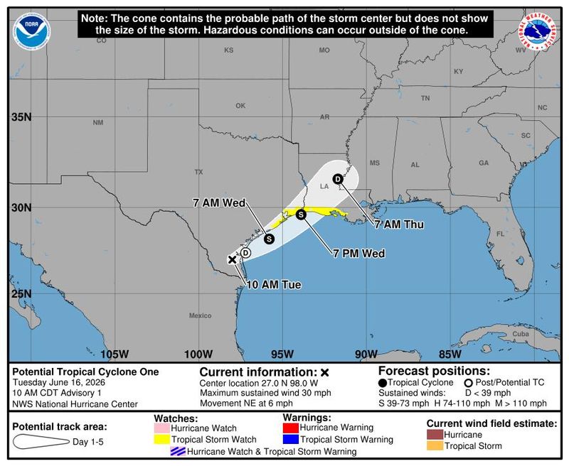
The National Hurricane Center in Miami, which began issuing advisories on Potential Tropical Storm One on June 16, said the system is expected to strengthen to a tropical storm by the morning of Wednesday, June 17, before making landfall later that night along the Texas or Louisiana coast.

Israel Gonzalez, meteorologist with the National Weather Service in Tallahassee, said the system will have a brief window to become a short-lived, low-end tropical storm.
“Whether it becomes a tropical storm or just stays a disturbance, it’s forecast to lift northward and interact with a front that’s to our north,” he said. “And a lot of that tropical moisture is going to just wring out a bunch of rainfall across the Mississippi Valley.”
In Tallahassee, he said, only indirect “fringe” effects will be felt — mostly in the form of rain and thunderstorms.
“We’re looking at multiple rounds of showers and thunderstorms with embedded heavy rainfall,” he said. “And then severe weather is also possible, being on the east side of these systems.”
Gonzalez said the most active weather day for Tallahassee will be Thursday, June 18.
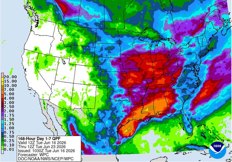
Massive rainfall amounts are not expected — Gonzalez said a total of one and a half to two inches of rain is possible over the next few days. As much as 7 inches of rain is possible near the border of Alabama and Florida through Sunday, June 21.
“There’s a dual threat for heavy rainfall capable of flooding and severe weather, where maybe we can get some spin-off tornadoes like we sometimes see with tropical systems, rain bands and things like that,” he said.
Absent any destruction, that means beneficial rainfall for Tallahassee, which has seen only 13.10 inches of rain so far this year, nearly 11 1/2 inches below the average of 24.51 inches.
“Any rainfall for sure is going to be helpful,” he said, adding that flooding remains a concern. “We’ve still got quite a bit of catching up to do before we do get to normal.”
‘Rain is going to be the biggest impact’
The Gulf is sufficiently warm to support cyclone spin up, and other conditions, including wind shear, are “marginally” welcoming for the formation of a tropical storm, according to the National Hurricane Center in an advisory early Tuesday June 16.
NHC meteorologists name a “potential tropical cyclone” or PTC when they want to issue watches and warnings for a system that technically hasn’t formed yet but is expected to impact land. A tropical cyclone is partly defined as having a closed center of circulation, which PTC One didn’t have as of early Tuesday.
The NHC issued a tropical storm watch at 11 a.m. Tuesday for areas from Sargent, Texas to Morgan City, Louisiana. In this case, the watch means tropical storm conditions are possible within 24 to 36 hours.
Regardless of whether the would-be Arthur gains purchase, areas of southern and eastern Texas and portions of Louisiana and Mississippi are expected to get spurts of intense rainfall for several days which may mean “widespread, life-threatening flash, urban and river flooding.”
Weather models show the system tracking over the Gulf late Tuesday, June 16, with winds increasing to tropical storm-force on Wednesday, June 17. It is then expected to move inland and cut quickly east with an exit into the Atlantic Ocean over the Carolinas.
Tropical cyclones are known to form along frontal boundaries early in the hurricane season as spring turns to summer. However, AccuWeather lead hurricane forecaster Alex DaSilva said he has never seen a genesis such as what’s happening with 90L.
The energy and moisture from the Pacific’s Cristina and the tropical wave came together in the Bay of Campeche, he said. The jet stream is helping pick up the combined forces and send them east with the help of high pressure that stretches deep into the Gulf.
“It’s very unusual,” DaSilva said. “But at the end of the day, the rain is going to be the biggest impact.”
Texas Gov. Greg Abbott has already declared a disaster declaration covering 101 Texas counties.
Contact Jeff Burlew at jburlew@tallahassee.com or 850-599-2180.
This article originally appeared on Tallahassee Democrat: Potential tropical storm could bring ‘fringe’ impacts to Tallahassee
Reporting by Jeff Burlew and Kimberly Miller, Tallahassee Democrat / Tallahassee Democrat
USA TODAY Network via Reuters Connect
By Jeff Burlew and Kimberly Miller, Tallahassee Democrat | USA TODAY Network