Concerned about the number of wildfires in Florida?
The Florida Forest Service provides a map showing all active fires in the state.

The map also shows how many acres have been affected and how much the fire has been contained.
➤ Weather alerts via text: Sign up to get updates about current storms and weather events by location
See the map below to track the locations of fires.
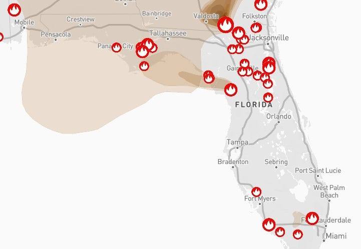
The number of active wildfires continues to climb, hitting 137 active fires burning more than 25,000 acres as of 6 a.m. April 23.
Map shows location of active wildfires, smoke impacts across Florida
As of 6 a.m. April 23, there were 137 active wildfires burning 25,248 acres across Florida.
According to the Florida Department of Agriculture and Consumer Services, between Jan. 1 and April 19 in Florida:
Smelling smoke? See air quality across Florida
According to the EPA, despite the number of wildfires and associated smoke, air quality in the state range from good to moderate.
➤ See breakdown of air quality by Florida county
Burn bans in effect in 41 Florida counties
As of April 23, burn bans have been issued for 41 of Florida’s 67 counties.
Interactive map: Enter your address to find closest wildfire risks
Stay informed. Get weather alerts via text
What’s next?
We will continue to update our weather coverage as conditions warrant. Download your local site’s app to ensure you’re always connected to the news. And look for our special subscription offers here.
Cheryl McCloud is a journalist for the USA TODAY Network-Florida’s service journalism Connect team. You can get all of Florida’s best content directly in your inbox each weekday day by signing up for the free newsletter, Florida TODAY, at https://tallahassee.com/newsletters.
This article originally appeared on Tallahassee Democrat: Map shows locations of active Florida wildfires. Are any near your home?
Reporting by Cheryl McCloud, USA TODAY NETWORK – Florida / Tallahassee Democrat
USA TODAY Network via Reuters Connect