Invest 98L is expected to become Tropical Storm Melissa today, Oct. 21.
If so, it’ll be the 13th named storm of the 2025 Atlantic hurricane season. Maximum sustained winds have to reach at least 39 mph to be designated as a tropical storm.

AccuWeather said it’s possible the system could become the next hurricane of the season in the warm waters of the central Caribbean.
➤Track Invest 98L
➤ Weather alerts via text: Sign up to get updates about current storms and weather events by location
The slow-moving storm is expected to bring heavy rain and gusty winds to the ABC islands over the next day or two.
Where the storm goes depends on several factors, including the location of the jet stream, but AccuWeather warned while there a low chance for a direct hit to the U.S. at this time, “it’s still on the table.”
Florida residents should monitor the the tropics closely and, as always, remain prepared.
Here’s the latest advisory from the National Hurricane Center as of 8 a.m., Oct. 21:
Invest 98L likely to become Tropical Storm Melissa today. Where will it go?
Special note on the NHC cone: The forecast track shows the most likely path of the center of the storm. It does not illustrate the full width of the storm or its impacts, and the center of the storm is likely to travel outside the cone up to 33% of the time.
Satellite, radar, and surface observations indicate that the area of low pressure over the central Caribbean Sea appears to be developing a well-defined center, and is already producing winds up to 45 mph.
A tropical storm is expected to form later today while it slows down over the central Caribbean Sea. Heavy rainfall and gusty winds are possible over portions of the ABC Islands during the next day or two.
Interests in Puerto Rico, Hispaniola, Jamaica, and Cuba should monitor the progress of this system as there is a risk of heavy rain and flooding, strong winds, and rough surf later this week.
The Air Force Hurricane Hunters are scheduled to investigate the system later today.
Spaghetti models for Invest 98L
Special note about spaghetti models: Illustrations include an array of forecast tools and models, and not all are created equal. The hurricane center uses only the top four or five highest performing models to help make its forecasts.
➤ Track Invest 98L
What is an invest?
Short for investigation, the National Hurricane Center uses the term invest for areas of low pressure it is monitoring for potential development into a tropical depression or storm.
Invests are not tropical depressions or tropical storms. They’re usually clusters of showers and thunderstorms, and just because they’ve been designated as an invest does not guarantee they’ll strengthen into a tropical storm or hurricane.
Invests run from 90 to 99, followed by a letter: L for the Atlantic basin and E for those in the eastern Pacific. After 99, it starts over again and the next invest would be 90.
Once something has been designated as an invest, specialized data sets and computer models can begin, including scheduling Hurricane Hunter aircraft missions and running spaghetti models.
Could Invest 98L, or Tropical Storm Melissa, impact Florida?
“While we think that the chances of a direct U.S. hit from this storm are low right now, it’s still on the table should the tropical system make it into the western Caribbean,” said AccuWeather Lead Hurricane Expert Alex DaSilva.
Where could Invest 98L go? See possible scenarios
The strength and location of the jet stream will be the biggest influence on the track of the rainstorm moving forward, according to AccuWeather.
“Historically, tropical systems that reach the western Caribbean in October are more likely to be steered away from places like Texas and Louisiana.
“But the eastern United States, and Florida in particular, can still be impacted by intense storms.”
What tropical waves, disturbances are in Atlantic basin now? How likely are they to strengthen?
The National Hurricane Center also is monitoring three other tropical waves, in addition to Invest 98L:
What do the colored, hatched areas on the NOAA map mean?
The hatched areas on the National Hurricane Center’s tropical outlook map indicate “areas where a tropical cyclone — which could be a tropical depression, tropical storm or hurricane — could develop,” said National Hurricane Center Deputy Director Jamie Rhome.
The colors make it visibly clear how likely a system could develop, with yellow being low, orange medium, and red high.
The National Hurricane Center generally doesn’t issue tropical advisories until there is a named storm, but there is an exception.
“If a system is near land and there is potential for development, the National Hurricane Center won’t wait before it issues advisories, even if the system hasn’t become an actual storm. This gives residents time to prepare,” Rhome said.
Who is likely to be impacted by Invest 98L, tropical waves out there?
It’s too early at this time to determine if there will be any impact to Florida or the U.S. from Invest 98L or the tropical waves.
➤ Excessive rainfall forecast
Forecasters urge all residents to keep an eye on the tropics and to always be prepared.
Florida weather radar for Oct. 21, 2025
Weather watches and warnings issued in Florida
When is the Atlantic hurricane season?
The Atlantic hurricane season runs from June 1 through Nov. 30.
Ninety-seven percent of tropical cyclone activity occurs during this time period, NOAA said.
The Atlantic basin includes the northern Atlantic Ocean, Caribbean Sea and Gulf of America, as the Gulf of Mexico is now known in the U.S. per an order from President Trump. NOAA and the National Hurricane Center are now using Gulf of America on its maps and in its advisories.
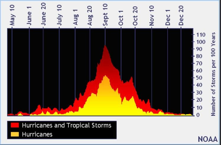
When is the peak of hurricane season?
The peak of the season is Sept. 10, with the most activity happening between mid-August and mid-October, according to the Hurricane Center.
Hurricane names for 2025 season
Here are the names for the 2025 Atlantic hurricane season, along with how to pronounce them. The first hurricane of the season typically forms Aug. 11.
National Hurricane Center map: See what forecasters watching now
Systems currently being monitored by the National Hurricane Center include:
Why does NHC say ‘tropical cyclone’ on its maps instead of hurricane or tropical storm?
Tropical cyclone is the generic term used by the National Weather Service, NOAA and the National Hurricane Center for any tropical system, even if it’s in the tropical Atlantic basin.
To be more precise, a tropical cyclone is a “rotating, organized system of clouds and thunderstorms that originates over tropical or subtropical waters and has closed, low-level circulation,” NOAA said.
Once maximum sustained winds reach 74 mph, what it is called is determined by where it originated:
Interactive map: Hurricanes, tropical storms that have passed near your city
Stay informed. Get weather alerts via text
What’s next?
We will update our tropical weather coverage daily.
Download your local site’s app to ensure you’re always connected to the news. And look for our special subscription offers here.
This article originally appeared on Naples Daily News: Invest 98L strengthening, could become Tropical Storm Melissa soon. Any Florida impacts?
Reporting by Cheryl McCloud, USA TODAY NETWORK – Florida / Naples Daily News
USA TODAY Network via Reuters Connect