

More than two months after the start of hurricane season, the tropics are mostly quiet − although there are tropical waves being monitored in the Atlantic and rain forecast for the Sunshine State.
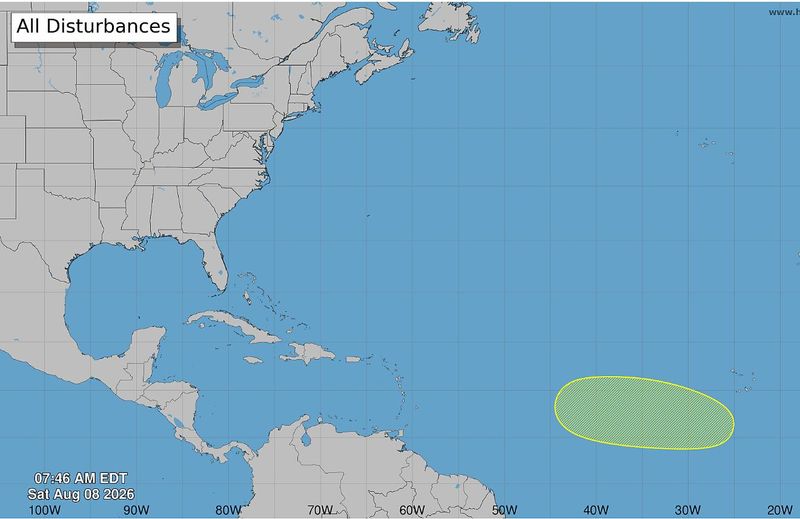
According to the Saturday, Aug. 8, 2026, weather advisory from the National Hurricane Center in Miami, Florida, forecasters are actively tracking a tropical wave in the eastern and central tropical Atlantic (see below). In addition, Florida has scattered showers on the weekend forecast.

Arthur, the first named storm of the hurricane season, briefly strengthened into tropical storm status June 17, 2026, before the hurricane center downgraded it to a disturbance not long after. Tropical Storm Bertha formed more than a month later − July 20, 2026, made its second landfall three days later near the Texas-Louisiana border, and quickly weakened.
➤ Track all active storms
Shop Home Depot for hurricane prep
There have been no other named storms so far into the second month of the 2026 Atlantic hurricane season.
In 2025, no storms made landfall in the U.S. during hurricane season, but it was an active one.
The hurricane center graphics and live weather radars below show what’s swirling in the tropics (if anything) as well as the conditions for potential rain, flash flood and other warnings.
Atlantic hurricane season is from June 1 to Nov. 30 every year, with the most activity between August and October. Should a weather system develop into a tropical storm, the third system would be named Cristobal, shown on the list of the 2026 Atlantic hurricane season names below.
The hurricane center resumed its tropics advisories ahead of hurricane season − on May 15.
➤ Weather alerts via text: Sign up to get updates about current storms and weather events by location
Keep reading for information about tropical storm activity for Saturday, Aug. 8, 2026.
National Hurricane Center in Miami, Florida, forecast on tropical activity: Is there a tropical storm or hurricane now?
According to the Saturday, Aug. 8, 2026, tropical outlook from the National Hurricane Center in Miami, Florida, forecasters were keeping watch on a system in the eastern and central tropical Atlantic. The graphic above automatically updates with the most recent location for any or all disturbances. The NHC reported:
A tropical wave was expected to move off the west coast of Africa on Tuesday. Some development of this system will be possible during the middle to latter part of next week while it moves westward across the eastern and central tropical Atlantic.
In its tropical weather discussion, the National Hurricane Center provided information about Florida, reporting that:
Scattered showers and thunderstorms are active over the Atlantic waters north of the Bahamas and west of 76W, following a low level trough currently moving across the Florida peninsula and into the eastern Gulf of America. Broad ridging centered on a 1024 mb high just northwest of Bemuda dominates the Atlantic north of 24N and west of 50W, supporting gentle to moderate east to southeast winds and 4-6 feet west of 50W. A central Atlantic cold front extends southwestward to near 33N50W and weakens the ridge across the central basin. An Azores High dominates the basin east of 40W, producing fresh to strong northeast winds near the Canary Islands, where seas are 6 to 8 feet. Saharan air and dust covers much of the Atlantic north of 12N and east of 55W.
For the forecast west of 55W, the surface trough moving across Florida will shift northwest and further inland today. Scattered showers and thunderstorms occurring east of the trough to 77W will shift northwestward behind the trough today, then persist north of 30N through Sunday. Otherwise, a 1024 mb Bermuda High will shift slightly southward to along 28N through Tuesday. Fresh east winds will prevail north of Hispaniola and in the approach to the Windward Passage through the period, pulsing to strong speeds each evening and night.
In addition, the National Hurricane Center was tracking these tropical waves on Saturday, Aug. 8, 2026:
The Atlantic basin consists of the northern Atlantic, Caribbean Sea and Gulf of America. NOAA changed its naming convention for the Gulf of Mexico after the U.S. Geological Survey changed the name on U.S. maps per President Trump’s order.
The USA TODAY Network in Florida will produce daily tropics watch advisories.
Is it raining in Florida today? Live weather radar
Shown is the National Weather Service radar, which shows conditions in real-time for the Southeast United States and parts of Central Florida. The current date and time show up on the bottom right of this radar embed; otherwise, you may need to clear your cache.
Weather watches and warnings issued in Florida
What are the 2026 Atlantic hurricane season names? Did your name make the hurricane season names list?
Since 1953, the National Hurricane Center has released a list of names in alphabetical order for Atlantic tropical storms before each season begins, which it recycles every six years. It retires names of storms that are excessively deadly or costly, if it would be insensitive or inappropriate to use them again. These are the 2026 Atlantic tropical cyclone names:
Interactive map: Hurricanes, tropical storms that have passed near your city
Stay informed. Get weather alerts via text
What’s next?
We will provided tropical weather coverage daily until Nov. 30 to keep you informed and prepared. Download your local site’s app to ensure you’re always connected to the news. And look for our special subscription offers here.
Contributing: Cheryl McCloud and Olivia Franklin, USA TODAY Network-Florida
This article originally appeared on Palm Beach Post: Hurricane center tracking tropical wave with low chance of formation
Reporting by Jennifer Sangalang, USA TODAY NETWORK – Florida / Palm Beach Post
USA TODAY Network via Reuters Connect
By Jennifer Sangalang, USA TODAY NETWORK – Florida | USA TODAY Network
