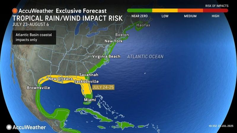
Florida may see more rain and thunderstorms today as a low-pressure area that swept over the northern part of the state July 24 moves across the Gulf, where it’s expected to soak the Texas coast and areas along the northern Gulf Coast.
The system became more disorganized as it traveled over the state but some slow development is possible as it moves westward, the National Hurricane Center said.

“Showers and thunderstorms into the weekend will bring additional impacts to much of the Gulf Coast,” AccuWeather forecasters said July 22, “There can be localized areas of flash flooding that can result in travel delays, as well as rough surf and rip currents along the coast.”
So what does this mean for Jacksonville?
According to the National Weather Service, there is a weak low pressure may develop over the eastern Gulf tonight or Friday. This low-pressure center will have a low chance for further development along the northern Gulf coast late this week. However, there are no local impacts in the Jacksonville area from tropical storms at this time.
There is, however, the possibility of isolated strong storms this afternoon and evening along the I-75 corridor, with wind gusts around 50 mph, localized flooding from heavy rainfall, and frequent lightning strikes. Storms are expected to be stronger between 2 and 8 p.m.
What’s the weather like in Jacksonville today: July 24, 2025
Today Jacksonville can expect a a hot and mostly sunny day, with highs near 93 degrees with a heat index pushing 103, making it feel much hotter according to the National Weather Service.
As for rain, they are calling a 30 percent chance of pop-up showers and thunderstorms this afternoon, especially between 2 and 5 p.m. A southeast breeze at 8 to 13 mph, with occasional gusts up to 20 mph, is also expected.
Partly cloudy conditions will continue into the evening, with a slight 10% chance of isolated showers before 8 p.m. Overnight lows will fall to around 76 degrees. Winds will remain light, shifting to the south after midnight, with gusts up to 16 mph possible.
Are there any weather alerts in Jacksonville today?
There’s currently no weather advisory in Jacksonville today. However, very hot temperatures, high heat index values and Heat Advisories are expected to return starting Friday and continue into early next week, as conditions could become dangerously hot during the afternoon hours.
What is the Tropical development in Florida?
Elsewhere, the NHC is tracking three tropical waves moving westward across the Atlantic: one near the Lesser Antilles, one in the open Atlantic, and a third off the coast of Africa.
The state is cooling off — well, becoming less hot — as the heat dome that has broiled much of the eastern United States all week continues to build toward the northern east coast. Approximately 130 million Americans are under extreme heat warnings or heat advisories Thursday, mostly from the Central Plains to the Northeast U.S.
There are no heat advisories for Florida for July 24, but that doesn’t mean it won’t be roasting out there wherever it’s not raining. Heat index values are expected to reach 105 in the northeast part of the state and 100 farther south.
➤ Weather alerts via text: Sign up to get updates about current storms and weather events by location
The next named storm of the 2025 Atlantic hurricane season will be Dexter.
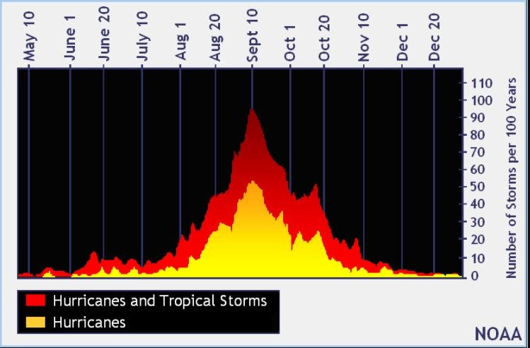
Historically, the fourth named storm of the Atlantic hurricane season arrives Aug. 15. The last two named storms of the season — Barry and Chantal — developed earlier than normal.
Here’s the latest tropical advisory from the National Hurricane Center as of 8 a.m. July 24:
Where is the low-pressure area?
A trough of low pressure over the northeastern Gulf is currently producing a broad area of disorganized showers and thunderstorms. Over the next day or two, this system is forecast to move generally westward across the north-central and northeastern portion of the Gulf where some slow development is possible.
By this weekend, the system is likely to move inland, ending its chances for development. Regardless of tropical cyclone formation, locally heavy rainfall is possible for portions of the northern Gulf coast through this weekend.
What else is happening in the tropics?
The National Hurricane Center is tracking three tropical waves.
Weather watches and warnings issued in Florida
Florida weather radar for July 24, 2025
National Weather Service Florida forecast for July 24
➤ How to set up emergency cellphone notifications for flash flood warnings and safety tips
➤ Excessive rainfall forecast
2025 hurricane season so far
An average Atlantic hurricane season has 14 named storms, seven hurricanes, and three major hurricanes.
Here’s when this year’s named storms have developed, compared to historical averages:
Hurricane names for 2025 season
Here are the names for the 2025 Atlantic hurricane season, along with how to pronounce them:
When is the Atlantic hurricane season?
The Atlantic hurricane season runs from June 1 through Nov. 30.
Ninety-seven percent of tropical cyclone activity occurs during this time period, NOAA said.
The Atlantic basin includes the northern Atlantic Ocean, Caribbean Sea and Gulf of America, as the Gulf of Mexico is now known in the U.S. per an order from President Trump. NOAA and the National Hurricane Center are now using Gulf of America on its maps and in its advisories.
When is the peak of hurricane season?
National Hurricane Center map: See what forecasters watching now
Systems currently being monitored by the National Hurricane Center include:
Why does NHC say ‘tropical cyclone’ on its maps instead of hurricane or tropical storm?
Tropical cyclone is the generic term used by the National Weather Service, NOAA and the National Hurricane Center for any tropical system, even if it’s in the tropical Atlantic basin.
To be more precise, a tropical cyclone is a “rotating, organized system of clouds and thunderstorms that originates over tropical or subtropical waters and has closed, low-level circulation,” NOAA said.
Once maximum sustained winds reach 74 mph, what it is called is determined by where it originated:
Interactive map: Hurricanes, tropical storms that have passed near your city
Stay informed. Get weather alerts via text
What’s next?
We will update our tropical weather coverage daily.
Download your local site’s app to ensure you’re always connected to the news. And look for our special subscription offers here.
This article originally appeared on Florida Times-Union: Hotter days and afternoon storms ahead for Jacksonville. Here’s when to expect the rain
Reporting by Doris Alvarez Cea and C. A. Bridges, Jacksonville Florida Times-Union / Florida Times-Union
USA TODAY Network via Reuters Connect