Unlike the government’s secret UFO stash of grainy videos of reflections, mirages, Michael Bay lens flares, and swamp gas reflected off the planet Venus, one thing credulous Mulders and skeptical Scullys can agree on is that the skies in 2025 were a bit less dark due to a coast-to-coast lack of U.S. hurricanes.
For those who have understandably Neuralyzed themselves to expunge memories of the last decade, 2017 through 2024 brought an unprecedented 10 major hurricane landfalls to the Gulf Coast, including six in Florida, which collectively tallied over $600 billion in damage.

Then, as suddenly as they arrived, they vanished, with zero close encounters of the Cat 3 kind (or any category) in 2025.
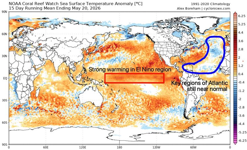
But can we remain alone in the universe in 2026? With lukewarm sea surface temperatures in the Atlantic and the arrival of a massive El Niño in the Pacific, WeatherTiger’s forecast models continue to predict paranormal activity, in the sense that below average overall activity and fewer than usual U.S. hurricane landfalls are the most probable outcome.
But what’s driving that prediction, and how much can we trust the (forecasting) authorities, anyway? It’s time to explain some aerial phenomena.
Here’s how many major hurricanes and tropical storms to expect in 2026
Before digging in, an introduction for new readers, or re-introduction for loyal Weather Fans: I’m Ryan Truchelut, Chief Meteorologist at WeatherTiger, a weather analytics and forensic meteorology company based in Tallahassee. I have a doctorate in meteorology from Florida State and over 20 years of professional hurricane forecasting and research experience, providing dad-humor-fortified storm analysis via the USA Today Florida Network for the last ten (!) years.
Expect regular columns between June and October, with more frequent forecasts as warranted.
One of the ways WeatherTiger’s seasonal outlook is different than other forecasts, like the just-released NOAA outlook, is that we spend relatively little time talking about how much total activity will happen.
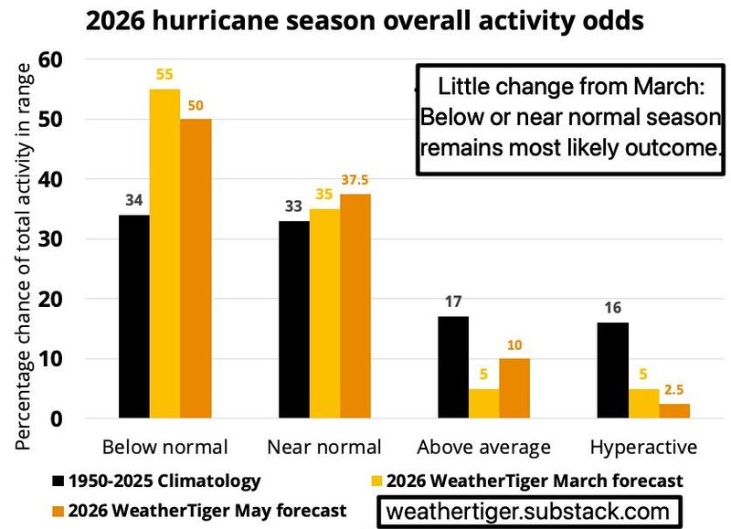
You don’t live in a mid-Atlantic shipping lane, so overall activity forecasts tell you little about your hurricane season to come. For what it’s worth, we see about a 50% chance of a below normal season and a 35-40% chance of a near-normal season.
The 2026 season is likely to notch 1 to 3 major hurricanes, 4 to 7 hurricanes, and 8 to 14 named storms (stopping at 8 would be nice, because I wouldn’t have to struggle to pronounce “Isaias”). The most likely Accumulated Cyclone Energy (ACE) tally, a weighted measure of how strong and long-lasting a season’s storms are, is about 75 units, or 30% less than average.
All six of our model components land between 55 and 110 ACE units. That’s solid internal agreement, and also quite similar to WeatherTiger’s March forecast and NOAA’s May forecast. Unlike any other forecasting group, our predictions change in real-time, and you can follow daily updates to our seasonal forecast model via weathertiger.com, with additional subscription options there for professional users.
Over the last ten years, WeatherTiger’s seasonal forecasts have the highest skill of any group between March and June, and just barely lag NOAA’s predictions in July.
We focus on landfall and impact expectations, because our goal at WeatherTiger is to provide objective, accurate forecasts that are useful and useable.
What to know about El Niño and La Niña, the heartbeat of hurricane seasons
These forecasts are based on recurring, persistent patterns in the ocean and atmosphere that exercise a predictable influence on global weather, including landfall risks. While El Niño and La Niña are often the most important climate pacemaker, the headlines of an imminent “super” El Niño mean that now is a great time to learn everything you always wanted to know about El Niño but were afraid to ask.
El Niño, first recognized by South American fishermen in the 1600s and later rediscovered by Chris Farley in the early 1990s, is defined as a long-lasting period of ocean temperatures at least 0.5°C warmer than average in the Equatorial Central Pacific Ocean. La Niña, conversely, is when the average ocean temperature in this same region is 0.5°C or more cooler than average. The irregular sequence of El Niño to neutral conditions to La Niña and back again in the Pacific takes anywhere from 3 to 7 years.
Just like a heartbeat, the whole circulation of the atmosphere is driven by these cycles.
When the waters of the Equatorial Pacific are warmer than average, the weak temperature contrast between the eastern and western Pacific slackens east-to-west surface trade winds. Not only do weaker trade winds cause additional ocean warming that sustains the El Niño, the resulting increase in Tropical Pacific thunderstorm activity induces a particular worldwide pattern to where air rises and sinks.
Once an El Niño or La Niña event begins, those patterns tend to lock in for one to two years, helping forecasters make long-range predictions.
That plays a major role in determining whether an Atlantic hurricane season is impactful or not.
When the Pacific is warmer than average, more hurricanes develop there, and the air rising up and through those storms induces winds over the western Atlantic that are stronger than normal from west-to-east aloft. That wind shear sprinting through Gulf and Caribbean like teens through a Scientology headquarters means fewer, weaker U.S. landfalls, on average.
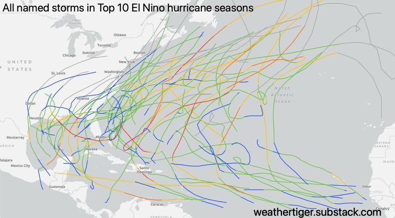
During the top 10 strongest El Niños since the 19th Century, U.S. landfall rates have been about half of long-term averages. Of course, those odds are subject to a healthy uncertainty; the last El Niño event in 2023 was accompanied by a major hurricane landfall, Idalia.
Like a fast-food drive-thru, climate is what you order, but weather is what is actually in the bag.
Since WeatherTiger’s March seasonal outlook, sea surface temperatures (SSTs) in the Equatorial Pacific have shifted dramatically warmer in a way last seen prior to the last two “super” El Niños in 1997 and 2015. (“Super” meaning Equatorial Pacific ocean temperatures are at least 2°C warmer than normal.)
Models are in good agreement that the start of official El Niño conditions should be declared in June, with continued Niñomaxxing to strong or super Niño intensity by the fall. It seems probable that this year will see one of the five strongest El Niños, and 2026 mogging the record 1877 event is in the realm of possibility.
A 30% chance of disaster for a major hurricane landfall on the U.S.
Everything I’m looking at on the El Niño front is good news for a quieter season, including in U.S. landfall terms. Still, while the top 10 fall Niños over last 175 years have all led to hurricane seasons 20% to 70% quieter than average, those years were not totally bereft of U.S. impacts.
The average number of U.S. named storms strikes in those 10 seasons was two to three, with zero to two hurricane landfalls. The 1877 El Niño recorded two Gulf hurricane hits, one of which was a Category 3 — a reminder that even quiet seasons usually see some impacts. Lower risk is not zero risk.
Taking a powerful El Niño, eastern Atlantic waters being close to or a little cooler than average, and a few other indicators of future steering currents into account, WeatherTiger’s seasonal model for U.S. hurricane strikes is projecting a 20% chance of no U.S. hurricane landfalls, 65% odds that there will be one or two, and just a 15% chance of three or more.
There is a roughly 30% chance of at least one U.S. major hurricane landfall in 2026, which is lower than the typical 40-45%, but again, not zero. Our model is confident that at least a few U.S. threats are coming, but a relentless onslaught is not expected: there’s a mere 1-in-50 shot of matching 2024’s five U.S. hurricanes.
A couple of final caveats: while an eventual strong or super El Niño is a high confidence forecast, other factors that influence landfall outcomes can pivot more quickly, especially if people are intentionally heating oceans to cause hurricanes so they can win Polymarket bets.
Zany schemes aside, the eastern Atlantic has had a few recent years with dramatic changes between May and September, so the outlook still could shift. Additionally, El Niño-dominated seasons can sometimes get off to a quick start in a way that disproportionately targets Florida.
Five of the top 10 El Niño seasons saw one or more U.S. named storm landfalls in May and June. Over half of total U.S. landfall activity in these years targeted Florida. Our landfall risk model suggests a higher-than-average proportion of what U.S. landfall activity there is in 2026 may be directed towards Florida.
I’ll be back in the first week of June to dig into how the early season is shaping up.
Overall, like an alien encounter, hurricane season can cause severe disorientation, time loss, and a general not-so-fresh feeling. I’m here to guide you through it with cool reason for a tenth consecutive season, and while the truth remains out there, I want to believe in another relatively calm year, as I’m sure you do unless you’ve got some ALFcoins (the official crypto of Melmac) riding on the opposite.
While I’m cautiously optimistic about the 2026 hurricane season, as always, have your hurricane kits and evacuation plans ready just in case, and keep watching the skies for any uninvited guests.
Dr. Ryan Truchelut is chief meteorologist at WeatherTiger, a Tallahassee company providing forensic meteorology expert witness, agricultural, and hurricane forecasting services. Email Truchelut at Ryan@weathertiger.com.
This article originally appeared on Tallahassee Democrat: Florida hurricane season forecast: Calmer with a 30% chance of calamity
Reporting by Ryan Truchelut, WeatherTiger / Tallahassee Democrat
USA TODAY Network via Reuters Connect