PANAMA CITY— A disturbance is heading toward the Gulf that will bring a lot of rain and possibly a tropical system to Bay County later this week amid some oppressive heat. Here’s a look at this week in weather.
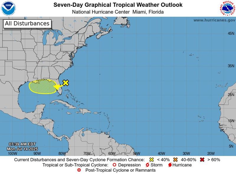
The National Hurricane Center is tracking a disturbance hovering off of the East Coast of Florida that is expected to move west over the state and into the northern Gulf. As of July 14, the system has a 30% chance of cyclone development over the next seven days.

Forecasters say that environmental conditions are favorable for gradual development. They warn that the system could produce heavy rainfall over Florida and the northern Gulf Coast that could result in flash flooding later this week.
Meanwhile, the National Weather Service expects brutal heat to persist in Bay County. The agency issued a heat advisory on July 14 warning of heat index values as high as 112 for the region. Temperatures are expected to remain high into July 15 before cooling off somewhat on July 16.
The weather service is asking residents to consider canceling outdoor activities, stay hydrated and check on pets and vulnerable groups of people.
Thunderstorms are likely after 2 p.m. on July 15, according to forecasters. They expect daily thunderstorms to persist through the remainder of the week. Daily rainfall chances are above 80% for July 16 through 18.
None of the impending storms are expected to be severe in Bay County, according to the Storm Prediction Center.
The weekend is anticipated to dry up a bit, with rainfall chances sitting at about 50% on July 19 and July 20. Forecasts show the temperature also cooling off somewhat with highs in the upper 80s.
Above average temperatures and precipitation are expected to persist for Bay County over the next two weeks, according to the Climate Prediction Center. They don’t anticipate additional tropical development over the next two weeks outside of the disturbance expected to hover over the northern Gulf.
Yellow flags were flying over Panama City Beach on July 14, indicating moderate surf or currents. Swimmers should use caution.
State Outlook
The National Hurricane Center is tracking an area of low pressure in the Atlantic off North Florida.
The system is forecast to move west into the Gulf Monday night through Tuesday morning. It currently has a 30% chance for tropical development over the next seven days and a 10% chance over the next 48 hours.
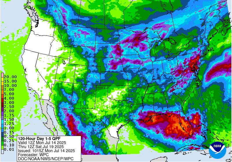
What does that mean for Florida? Get ready for a wet week; make that a very wet week, with a potential for localized flooding, rough surf and dangerous rip currents.
➤ Track all active storms
➤ Weather alerts via text: Sign up to get updates about current storms and weather events by location
The next named storm of the 2025 Atlantic hurricane season will be Dexter.
Historically, the fourth named storm of the Atlantic hurricane season arrives Aug. 15. The last two named storms of the season — Barry and Chantal — developed earlier than normal.
Here’s the latest advisory from the National Hurricane Center as of 8 a.m., July 14:
Area of low pressure expected to move across Florida
An area of low pressure located offshore the east coast of Florida is producing disorganized showers and thunderstorms, according to the 8 a.m. advisory from the National Hurricane Center.
This disturbance is forecast to move westward across Florida during the next day or so, and into the northeastern Gulf by late Tuesday.
Environmental conditions appear favorable and some gradual development of this system is possible while it moves westward to west-northwestward across the northeastern and north-central portions of the Gulf during the middle to latter part of this week.
Regardless of development, heavy rainfall could produce localized flash flooding over portions of Florida and the north-central Gulf coast through the middle to latter portion of this week.
What do the colored, hatched areas on the NOAA map mean?
The hatched areas on the National Hurricane Center’s tropical outlook map indicate “areas where a tropical cyclone — which could be a tropical depression, tropical storm or hurricane — could develop,” said National Hurricane Center Deputy Director Jamie Rhome.
The colors make it visibly clear how likely a system could develop, with yellow being low, orange medium, and red high.
The National Hurricane Center generally doesn’t issue tropical advisories until there is a named storm, but there is an exception.
“If a system is near land and there is potential for development, the National Hurricane Center won’t wait before it issues advisories, even if the system hasn’t become an actual storm. This gives residents time to prepare,” Rhome said.
What impacts are expected in Florida?
➤ Excessive rainfall forecast
“Regardless of development, an increase in showers and thunderstorms can occur from the Carolinas into Florida and along parts of the Gulf coast which can lead to localized flooding. Rough surf and rip currents can also occur,” according to AccuWeather.
➤ How to set up emergency cellphone notifications for flash flood warnings and safety tips
➤ Excessive rainfall forecast
“Heavy rainfall with flooding in low-lying and poor drainage areas are possible, regardless of development,” the National Weather Service Tampa Bay agreed.
Expect rain chances in the Tallahassee area to increase Wednesday and Thursday, the National Hurricane Center Tallahassee said. On July 14, damaging wind gusts in the afternoon could accompany strong storms, along with some hail.
Strong to severe thunderstorms are expected Monday, July 14, and could bring frequent lightning, strong winds of 40 to 60 mph and locally heavy downpours, according to the National Weather Service Jacksonville.
Florida weather radar for July 14, 2025
Florida weather forecast for July 14, 2025
Florida weather forecast for July 14, 2025
2025 hurricane season so far
An average Atlantic hurricane season has 14 named storms, seven hurricanes, and three major hurricanes.
Here’s when this year’s named storms have developed, compared to historical averages:
Weather watches and warnings issued in Florida
Hurricane names for 2025 season
Here are the names for the 2025 Atlantic hurricane season, along with how to pronounce them:
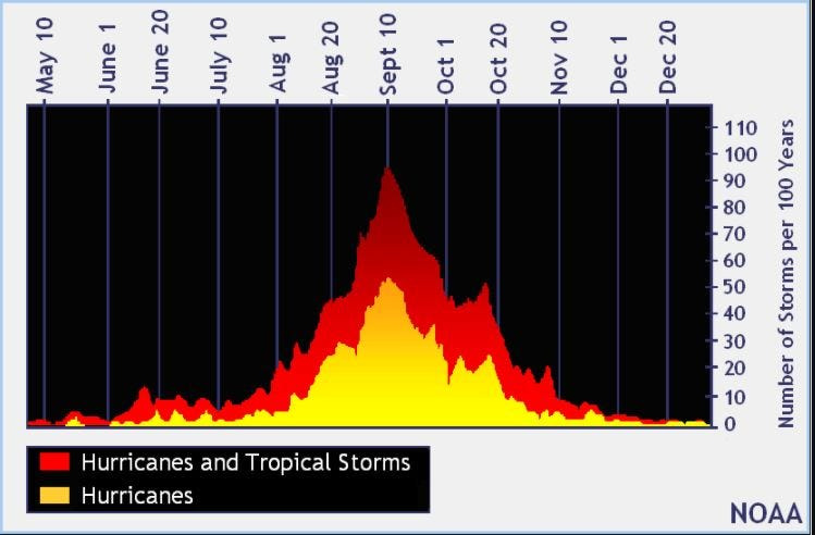
When is the Atlantic hurricane season?
The Atlantic hurricane season runs from June 1 through Nov. 30.
Ninety-seven percent of tropical cyclone activity occurs during this time period, NOAA said.
The Atlantic basin includes the northern Atlantic Ocean, Caribbean Sea and Gulf of America, as the Gulf of Mexico is now known in the U.S. per an order from President Trump. NOAA and the National Hurricane Center are now using Gulf of America on its maps and in its advisories.
When is the peak of hurricane season?
National Hurricane Center map: See what forecasters watching now
Systems currently being monitored by the National Hurricane Center include:
Why does NHC say ‘tropical cyclone’ on its maps instead of hurricane or tropical storm?
Tropical cyclone is the generic term used by the National Weather Service, NOAA and the National Hurricane Center for any tropical system, even if it’s in the tropical Atlantic basin.
To be more precise, a tropical cyclone is a “rotating, organized system of clouds and thunderstorms that originates over tropical or subtropical waters and has closed, low-level circulation,” NOAA sadi.
Once maximum sustained winds reach 74 mph, what it is called is determined by where it originated:
Interactive map: Hurricanes, tropical storms that have passed near your city
Stay informed. Get weather alerts via text
What’s next?
We will update our tropical weather coverage daily.
Download your local site’s app to ensure you’re always connected to the news. And look for our special subscription offers here.
This article originally appeared on The News Herald: Could a tropical system threaten Bay County? Disturbance brews amid brutal heat
Reporting by Dylan Gentile and Cheryl McCloud, USA TODAY NETWORK – Florida / The News Herald
USA TODAY Network via Reuters Connect