Thunderstorms are expected to develop over Greater Lansing Thursday afternoon, March 26, as a band of potentially severe weather crosses Michigan’s southern Lower Peninsula.
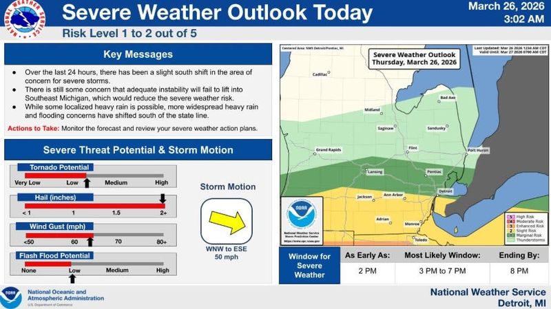
“Over the 24 hours, there has been a slight south shift in the area of concern for severe storms,” the Detroit NWS office said on X on March 26. “There is still concern that adequate instability will fail to lift into southeast Michigan, which would reduce the severe weather risk. While some localized flooding is possible, more widespread heavy rain and flooding concerns have shifted south of the state line.”

In Lansing, thunderstorms are forecast to develop as early as 11 a.m. on Thursday, March 26, ending around 1 p.m. with rain lingering into the overnight hours. Lansing is expected to see a high of 64 degrees and a low of 27 degrees, according to the hourly National Weather Service forecast.
Cities nearest to the Ohio border have the greatest potential for severe weather, the NWS said.
Wind gusts up to 70 mph, large hail — more than 2 inches in diameter, flooding, and potential isolated tornadoes are possible hazards, according to the National Weather Service’s hazardous weather outlook for southern Michigan.
By Friday morning, March 27, Lansing is expected to see up to 0.5 of an inch of rain, according to the Probabilistic Precipitation Portal.
Officials urge residents to review their severe weather plan and to stay weather aware through Thursday, March 26.
Here’s the live radar and current warnings in place in Michigan.
Where are storms moving? Michigan live Doppler radar
Current watches, warnings and advisories in Michigan
Contact Sarah Moore @ smoore@lsj.com
This article originally appeared on Lansing State Journal: When is it supposed to storm? Forecast, rain amounts for Lansing
Reporting by Sarah Moore, Lansing State Journal / Lansing State Journal
USA TODAY Network via Reuters Connect