Much has changed about downtown Holland since 2005, with storefronts changing hands, large-scale developments, road construction and demolitions.
Through historical photos on Google Earth, these changes be seen from the skies. The first clear, in-color image taken above downtown Holland dates to 2005. There aren’t snapshots available for every year — meaning an occasional two, three or four-year jump in between — but the journey is interesting nonetheless.

Here’s a summary of notable changes, as apparent from above, in and around downtown:
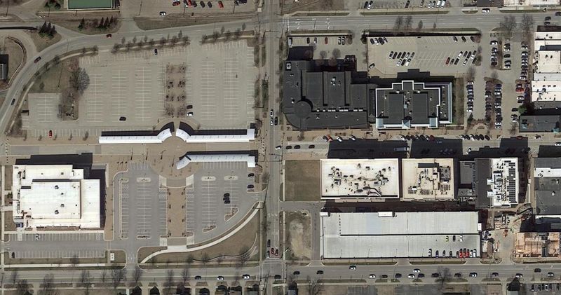
West Eighth Street
Some of the most notable changes over the last 20 years of Google Earth images occur on the west end of downtown Holland, particularly on Eighth Street and Ninth Street.
Aerial photography from 2005 shows a pre-renovation Holland Civic Center, no parking garage along Ninth Street, and the late stages of construction on the current site of the Holland Department of Public Safety and 58th District Court Building. Also missing are multiple commercial/residential buildings from GDK that line Eighth Street in 2025.
The next clear photo comes in 2010, showing a fully finished HDPS and 58th District Court.
Major changes begin to show in 2016, taken after several buildings along Ninth Street east of Pine Avenue have been demolished.
In 2017, work is underway on the Ninth Street Parking Garage and the transformative renovation of Holland Civic Center has begun.
In 2018, significant construction progress has clearly been made. The Ninth Street Parking Garage is complete, as is the building that now houses HopCat and Sperry’s Moviehouse. The updated Holland Civic Center is on full display.
The images then jump to 2021, showing another building addition along Eighth Street, now home to Bondi Suites, Mezkla Taqueria and Sprinkles Donut Shop.
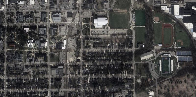
Hope College
Google Earth also shows recent growth at Hope College. The addition of several new facilities has been documented since 2005.
Between snapshots of 2011 and 2013, several changes to the college’s athletic facilities are made. Hope purchased the former Holland Municipal Stadium on Fairbanks Avenue in 2012, renamed the Ray and Sue Smith Stadium. You can see the renovated stadium in 2013, along with updates to the surrounding fields and new tennis courts.
In 2021, initial work on the Jim Heeringa Athletic Center on the north end of the stadium can be seen. That work is finished by 2022.
In a jump from 2013 to 2016, two campus additions along Columbia Avenue are visible, including the Jack H. Miller Center for Musical Arts and the Kruizenga Art Museum. You can also see construction at the Jim and Martie Bultman Student Center, completed by 2017.
Also in 2017, early work on the extension of Western Theological Seminary along 13th Street can be seen. The project is complete by 2018, but work has already begun on yet another neighboring building. By the next photo in 2021, construction is complete.
Other additions, losses near downtown
Several other changes in and around downtown Holland can be seen from above while looking through the lens of Google Earth.
In a jump from 2006 to 2010, the parking garage on Seventh Street on the east end of downtown appears.
When jumping from 2013 to 2016, the building that houses the Courtyard by Marriott and Big E’s Sports Grill on Eighth Street becomes visible. You can also spot construction on Holland Energy Park along Chicago Drive, completed by 2017.
In a snapshot from 2024, the James DeYoung Power Plant on Pine Avenue has been demolished, and construction of the Holland Community Ice Skating Park along Sixth Street has begun.
— Contact reporter Mitchell Boatman at mboatman@hollandsentinel.com.
This article originally appeared on The Holland Sentinel: Visuals: Google Earth shows how downtown Holland has changed since 2005
Reporting by Mitchell Boatman, Holland Sentinel / The Holland Sentinel
USA TODAY Network via Reuters Connect