A powerful winter storm battered northern Michigan and the Upper Peninsula on Monday, leaving more than 124,000 customers without power, closing schools and offices, and making travel dangerous or impossible in some areas due to heavy snow and strong winds.
The storm also was on track to set record snowfalls in certain regions of Michigan.

Spalding appeared to set a one-day record in the UP’s Menominee County with 35 inches of snow, more than doubling the old record of 15 inches set near Daggett in 2012.
An observer station two miles south of Herman in L’Anse Township in Baraga County also appeared to set a new one-day record with 34 inches of snowfall in the past 24 hours, breaking a record of 32 inches set in 1985.
The Southeast Forest Lake area of Alcona County in Michigan’s northeastern part of the lower peninsula got hit with 31.9 inches, a new record surpassing the prior mark of 27 inches set in 1929.
Marquette County’s Negaunee on Sunday broke the snow record for March 15 with 14.6 inches of snow, eclipsing the prior mark of over 12 inches, said Chris Burling, a meteorologist at the Marquette National Weather Service in Negaunee.
Negaunee had 29.4 inches of snow unofficially accumulated through Monday morning, according to the National Weather Service. Other records, such as one-day or two-day all-time record snowfalls, were still being measured and have yet to be determined, Burling said.
Meteorologists said the storm formed from a large and organized system across the Great Lakes, bringing widespread snow and a band of freezing rain along its southern edge.
Power outages were concentrated particularly north of Mount Pleasant. Consumers Energy reported more than 90,000 outages and deployed more than 480 crews working extended shifts to assess damage and restore service. The utility said the storm had a major impact in areas stretching from Cadillac to Alpena.
Blizzard conditions were expected to continue into Tuesday across the northern Lower Peninsula and much of the Upper Peninsula. Forecasters predicted an additional one to two feet of snow in parts of the region, including Marquette, along with wind gusts reaching 50 mph near Lake Superior. Snowfall totals already ranged from about 7.5 inches near Sault Ste. Marie to 23 inches in St. Ignace.
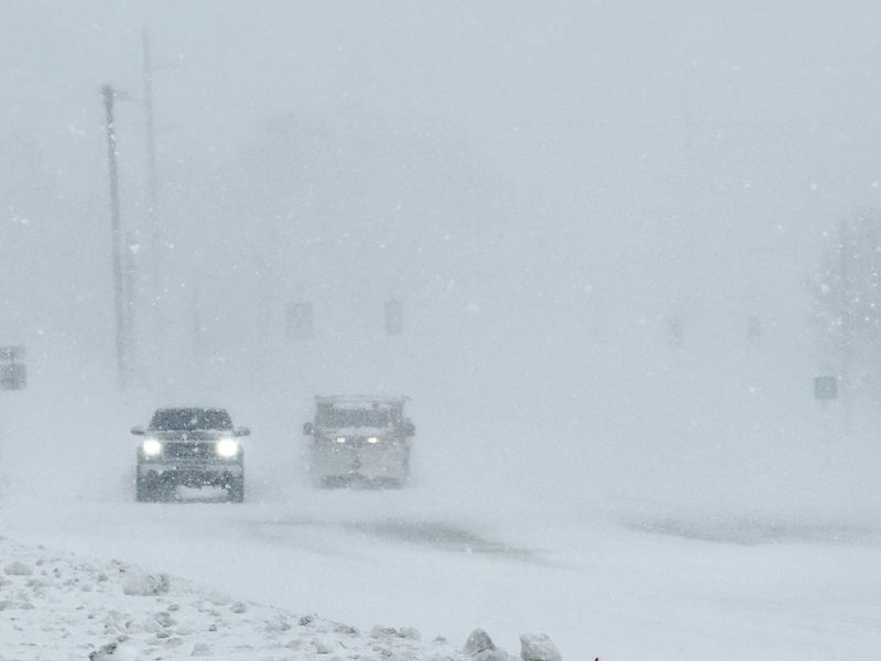
Travel conditions were extremely hazardous, with the National Weather Service advising residents in the hardest-hit areas not to drive. In areas outside the blizzard zone, officials urged motorists to slow down, maintain extra distance, and ensure vehicles were properly equipped for winter conditions.
On Sunday, Gov. Gretchen Whitmer activated the state’s Emergency Operations Center to coordinate response efforts, while several counties declared local states of emergency and many state offices closed. In Traverse City, near-whiteout conditions blanketed downtown streets, shutting down businesses and government offices and prompting officials to urge residents to avoid unnecessary travel.
The heaviest snowfall from the weekend winter storm fell across Michigan’s Upper Peninsula, where several locations reported more than two feet of accumulation in 48 hours, according to the National Weather Service. The highest total came from an observer station south of Herman in Baraga County, which measured 36 inches over 48 hours, including 34 inches in the most recent 24-hour period. Other U.P. communities also reported major totals, including 31 inches in Three Lakes (Baraga County) and 31 inches in Menominee County, while National Mine in Marquette County recorded 30 inches by early Monday.
Snowfall was also significant across parts of northern Michigan in the Lower Peninsula, though totals were generally lower than in the U.P. Communities such as Petoskey, Saint Ignace, Harbor Springs and Charlevoix saw substantial accumulation, while areas farther south, such as Traverse City and Cheboygan, reported lighter totals as the storm weakened toward the southern edge of the system.
Reported snowfall totals in Michigan
The heaviest snowfall from the weekend winter storm fell across Michigan’s Upper Peninsula, where several locations reported more than two feet of accumulation in 48 hours, according to the National Weather Service. The highest total came from an observer station south of Herman in Baraga County, which measured 36 inches over 48 hours, including 34 inches in the most recent 24-hour period. Other U.P. communities also reported major totals, including 31 inches in Three Lakes (Baraga County) and 31 inches in Menominee County, while National Mine in Marquette County recorded 30 inches by early Monday.
Three feet of snow tops the list so far
Authorities warn Michigan drivers to stay off the roads
Sheriff’s offices across Michigan’s northern Lower Peninsula and the Upper Peninsula urged residents to stay home. Officials warned that vehicles were becoming stuck and that travel could be delayed as emergency responders struggled to clear heavy snow.
In Schoolcraft County, deputies described road conditions as “terrible,” with several side roads completely blocked and vehicles stranded. The county had received about 27.5 inches of snow by Monday morning, and authorities said they hoped plows could reopen roads by Tuesday if snowfall eased.
Authorities in other northern counties issued similar warnings. The sheriff’s office in Otsego County said many roads were impassable and advised residents not to travel, while officials in Roscommon County asked drivers to stay home after a tree fell onto a county administrator’s vehicle during the storm.
In Alpena County, officials reported more than 5 inches of snow and freezing rain, with downed trees and power lines adding to the danger. Meteorologists at the National Weather Service warned that isolated blizzard-like conditions and falling temperatures could worsen conditions and potentially bring down more tree branches and power lines.
Blizzard closes schools, universities in Michigan
The heavy snow and strong winds from a blizzard forced widespread school closures across northern Michigan and the Upper Peninsula on Monday, with some districts already canceling classes for Tuesday.
Districts including Menominee Area Public Schools and Iron Mountain Public Schools canceled classes Monday and Tuesday, citing unsafe road conditions, while Traverse City Area Public Schools, Gaylord Community Schools, Petoskey Public Schools, and Cheboygan Area Schools also closed Monday as steady snowfall and drifting made it difficult for road crews to clear roads.
Colleges and universities across the region also shut down Monday because of the storm. The Upper Peninsula’s three public universities — Michigan Technological University, Northern Michigan University, and Lake Superior State University — suspended operations for the day, while several community colleges in northern Michigan and the Upper Peninsula also canceled classes, including Alpena Community College, Bay College, Gogebic Community College, Kirtland Community College, North Central Michigan College, Northwestern Michigan College, and West Shore Community College.
Staff Writers Max Bryan, Charles E. Ramirez, Sarah Atwood and Jennifer Pignolet contributed.
This article originally appeared on The Detroit News: Michigan blizzard: Everything you need to know about the snowstorm
Reporting by Detroit News staff reports / The Detroit News
USA TODAY Network via Reuters Connect