This story was updated at 1:30 p.m. with a weather alert.
Greater Lansing is under a severe thunderstorm watch while storms move into the state on Monday afternoon and evening, July 27.

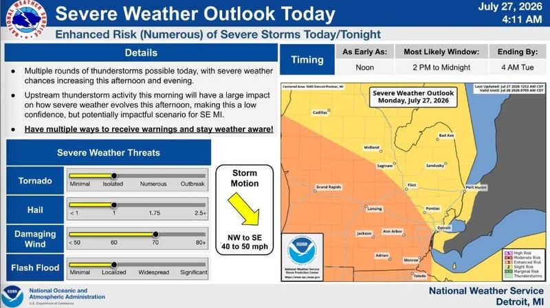
Storms systems crossing Lake Michigan are expected to cover parts of mid-Michigan Monday afternoon and evening, July 27. The National Weather Service issued a severe thunderstorm watch until 8 p.m. on July 27, for several counties in the south-central and southwest L.P. including Ingham, Clinton and Eaton, Gratiot and Ionia counties.
Conditions could grow severe producing isolated tornadoes, 1-inch hail, 60-70 mph wind gusts, lightning and localized flash floods.
Major cities such as Greater Lansing, Metro Detroit, Grand Rapids, Ann Arbor, Kalamazoo, Muskegon, Benton Harbor and Monroe are expected to see the worst of the storm, according to the National Weather Service Storm Prediction Center.
In Lansing, thunderstorms are expected to arrive after 5 p.m. and linger into the overnight hours, according to the hourly weather forecast.
Residents are urged to have multiple ways of receiving weather alerts during the day and night.
Lansing is projected to have high of near 88 degrees and a low of around 67 degrees on Monday, July 27.
Here’s the live radar and the current weather alerts issued for Michigan:
Where are storms moving in Michigan? Live Doppler radar
Current weather warnings, watches and advisories in Michigan
Contact Sarah Moore @ smoore@lsj.com
This article originally appeared on Lansing State Journal: Greater Lansing under severe thunderstorm watch. See forecast, radar
Reporting by Sarah Moore, USA TODAY NETWORK / Lansing State Journal
USA TODAY Network via Reuters Connect

By Sarah Moore, USA TODAY NETWORK | USA TODAY Network