
By Fred Fuller

Most people are probably not aware that the Blue Water Area has an unusual landform of ancient beach ridges and wetland swales that exists about one-half to one mile inland from the shore of Lake Huron in Fort Gratiot and Burtchville Townships, north of Port Huron.
It is technically known as a “wooded dune and swale complex,” and it consists of a series of parallel sand ridges alternating with muck-filled swales (shallow valleys) between the ridges. Some rarely seen plants and animals are found in these habitats, such as Purple-Flowering Raspberry, Hognose Snake, and Yellow Lady-slipper Orchid.

The sand ridges formed about 4,500 years ago as the high post-glacial Lake Nipissing receded due to the rapid down-cutting of the then-new Saint Clair River. The ridges were first deposited as sandbars, then, as the water of the ancient lake lowered, the ridges were shaped by the wind, like dunes, until they were stabilized by woodland cover. Wetland plants and trees grew in the water trapped between the ridges, building up deposits of fertile muck soil, while different plants and trees grew on the dry sand ridges.
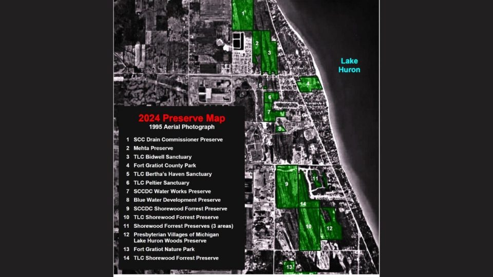
The surviving ridges and swales can be clearly seen in aerial photos, but you will also see in aerial photos that most of that landscape along Lake Huron has been developed for shopping malls and subdivisions. Many of the sand ridges were also mined for construction material.
The Thumb Land Conservancy (TLC), a local 501(c)3 non-profit charitable organization, has a vision for creating a 4.5 mile trail system, called the Southern Lake Huron Coastal Park, along a string of parcels that will preserve what’s left of that ancient landscape and allow people to observe it. And the vision is not so far off now, since they’ve been working on it for over ten years.
The Executive Director of the TLC, Bill Collins, grew up in Fort Gratiot Township, north of Port Huron, and had the opportunity, as he was growing up, to explore some of the wetland woods that surrounded his neighborhood. He was fascinated by the diversity of native plants that flourished there due to the woods never having been developed or farmed. That was because these woods were what some might call “a swamp.”
There is a big difference between what is a typical woods now in the Thumb of Michigan, and what is a truly natural Michigan forest that has native plants and trees. If you’ve never been in a native forest, you would notice an amazing difference when you enter one. The rich diversity of native trees and wildflowers is nothing like what you see in most woodlots today. That’s because most forests in the area were once logged and farmed, or heavily
grazed by livestock, which decimated most of the native Michigan plants and trees, and when the forest re-grew, it was usually with non-native weeds and a few types of trees that can sprout in open land.
Bill Collins and his wife, Cheryl, founded the Thumb Land Conservancy in 2008 as an organization dedicated to preserving natural areas in Michigan’s Thumb. The TLC now owns 15 nature sanctuaries, comprised of 366 acres, and has four other properties preserved by conservation easements, totaling 147 acres. The TLC is currently working to preserve an additional 300 acres.
The proposed Coastal Park trail system would mostly follow the tops of the old beach ridges, which are roughly a mile inland from the lakeshore. But it would also connect to the Fort Gratiot County Park on the lake and the day-use portion of Lakeport State Park.
Beginning in 2010, TLC acquired a string of properties through purchase and donation that will form the coastal park (see maps). Some of the properties are protected under conservation easements given to the State of Michigan as mitigation for small and/or low-quality wetlands that were impacted by developments, as in the case of the Shorewood Forrest Subdivision and Presbyterian Villages of Michigan. Others were purchased by St. Clair County Drain Commissioner (SCCDC) Robert Wiley as mitigation for wetland impact during drainage projects.
Some of the necessary properties have been purchased outright by the TLC with generous grants from The Carls Foundation, the North American Wetland Conservation Committee, Consumers Energy Foundation, the Community Foundation of St. Clair County, the Community Foundation for Southeast Michigan, Cargill Incorporated, and SEMCO Energy Gas Company, as well as with contributions from individual donors.
The TLC is currently working to raise funds to cover the purchase of additional properties that are critical connections for the trail system. If you would like to help support this project, or if you would like any additional information about Thumb Land Conservancy’s nature sanctuaries, projects, and activities, visit their website at: http://www.thumbland.org
There are wonderful photos of native plants recently found on TLC sanctuaries in their July 3, 2025, newsletter, The Thumb Naturalist, which is available digitally on the website.