
By Fred Fuller

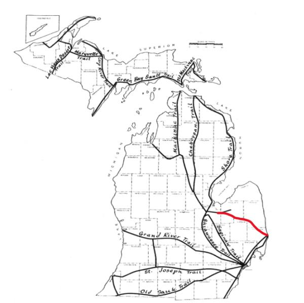
There is a series of roads that angle across the “Thumb” of Michigan, from Port Huron northwesterly through the villages of Clifford, Mayville, Vassar, and up to the Saginaw River valley. In the past, my family would often take this route to drive “up north” to the woodlands of the northern lower peninsula of Michigan.
My father told me that his father told him that this route followed an old “Indian trail” that the Indians (which Native Americans were commonly called back then) used in traveling from the rapids of the St. Clair River at Port Huron, where the Blue Water Bridges to Canada are now, up to Saginaw Bay. He said they traveled the trail seasonally, to fish at the rapids in the spring and summer, and then they’d go up to the marshlands around Saginaw Bay to hunt waterfowl in the fall.

Long ago, there were rapids at Port Huron where Lake Huron empties into the St. Clair River. The rapids were dredged out many years ago in order to facilitate ship passage from the lower Great Lakes through to the upper Great Lakes.
I have not found any other historical reference to this old Native American trail. Published maps of Native American trails in Michigan, such as Wayne State University’s commonly used “Chief Indian Trails in Southern Michigan,” drawn circa 1933, do not show the trail across the Thumb.
Wilbert B. Hinsdale (1851-1944) published the most authoritative studies of Native American sites in Michigan. His Archaeological Atlas of Michigan is still the most comprehensive source available. Although a medical doctor by profession, he had a lifelong interest in archeology, and he collected a great deal of archeological information in his spare time and in retirement. Working with the University of Michigan, he helped create the Michigan Museum of Anthropological Archaeology in Ann Arbor. His colleagues called him “the father of Michigan archeology.”
Hinsdale’s Atlas has maps that show fragments of what might have been the Port Huron to Saginaw trail, but he didn’t acknowledge this route. However, if you look at a Michigan highway map, you’ll see a paved road that angles northwesterly from M-53, south of Marlette, through Clifford, Silverwood, Mayville, Juniata, Vassar, and Richville, in Tuscola County. If you look at county maps that show gravel roads, you’ll see that there are gravel roads, many miles to the southeast in Sanilac County, that line up with that paved route in Tuscola County: Fremont Road and Comstock Road. And those roads line up with Pine Grove Avenue in Fort Gratiot Township, which angles toward the Blue Water Bridges in Port Huron.
There are big gaps between these sections of roads where the trail was apparently abandoned when new sectional county roads were laid out every square mile. But I have an 1873 Michigan atlas that shows a section of road, now abandoned, that was also in the same alignment from the western border of Speaker Township in Sanilac County, up through Maple Valley Township and Flynn Township.
From Richville, in Tuscola County, it’s not so obvious where the trail might have gone. It probably split into several branches. Michigan Highway M-15 angles northward from Richville to Bay City. But in perfect alignment with the trail, if it left Richville continuing northwesterly, there is an old community in Saginaw County called “Indiantown.” According to a 2011 book by Ruth Ederer entitled, Indiantown: An Ojibwe Village Becomes A Farm Community, this was the site where: “…a band of Chippewa Indians lived along both sides of the Cheboyganing Creek for more than a century. The United States Government granted several acres of swampland after 1850 to local Indian Chief Noc-a-chick-a-me, who signed the Treaty of 1819, Medicine Man John Me-Squon-da, and Luke Ne-te-mp, who lived to be 120 years old.” Their descendants later sold the land to German immigrants who turned it into farmland.
Several sources, including Wilbert B. Hinsdale, say that the Saginaw area was the epicenter of the Native American population in Michigan. Hinsdale identified the location of 109 Chippewa (also known as Ojibwe) villages in the area. It was the hub of many trails leading in all directions to other parts of Michigan, and it was where the Tittabawassee, Shiawassee, Cass, and Flint Rivers all converged to form the Saginaw River, which flows into Saginaw Bay. So, it was also the perfect hub for water travel by canoe, up the various rivers or out into Lake Huron.
The Port Huron area was also an important site of Native American settlement. Hinsdale identified 22 burial mounds in that vicinity and several villages. There was a Chippewa reservation in Port Huron on the south side of Black River from 1807 to 1836. It makes sense that there would be a direct trail from Port Huron to the Saginaw area.
So far, I have only one other piece of corroborating evidence for the trail. A friend of mine, Carrie Ferguson, grew up on a farm along Fremont Road in Speaker Township, which would have been part of the trail. She said her father told her that there was a story in the family about how “Indians” used to walk along the road in front of their farmhouse. That farmhouse, still standing, is of an architectural style known as Greek Revival, which indicates it was built about 1850 to 1860. That means it would have been there when some Native Americans were probably still making the trek on foot between Port Huron and Saginaw.
If anyone knows of any more information about this “lost” Native American trail, please email me at fredfuller1776@gmail.com.