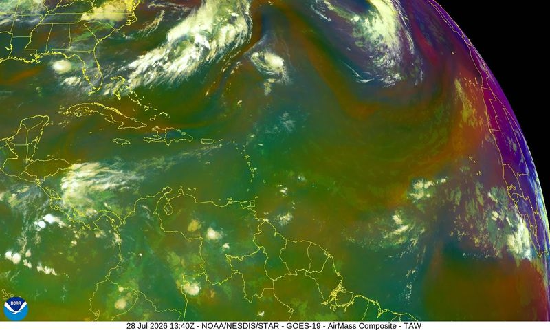
More Saharan dust is moving across the Atlantic toward Florida, which is helping keep any tropical cyclones from developing.
That doesn’t mean you should let your guard down. Forecasters still warn residents should be prepared, especially as we approach the busiest portion of the season.

➤ Track all active storms
In the Pacific, Hurricane Genevieve is slowly weakening July 28, while Tropical Storm Fausto is expected to pass north of the Hawaiian Island tonight, July 28-29, bringing “significant surf.”
Shop Amazon for hurricane prep
The next named storm in the Atlantic will be Cristobal. The third named storm in the Atlantic typically forms around Aug. 3, according to NOAA.
➤ Weather alerts via text: Sign up to get updates about current storms and weather events by location
Heat continues to impact Florida July 28, with extreme heat warnings and heat advisories issued for millions across the Panhandle and peninsula.
Here’s the latest advisory from the National Hurricane Center as of 2 p.m., July 28:
When is hurricane season in Florida?
The Atlantic hurricane season runs from June 1 through Nov. 30.
Ninety-seven percent of tropical cyclone activity occurs during this time period, NOAA said.
➤ Hurricane Center testing new cone: What’s changing this season?
The Atlantic basin includes the northern Atlantic Ocean, Caribbean Sea and Gulf of America, as the Gulf of Mexico is now known in the U.S. per an order from President Trump. NOAA and the National Hurricane Center are now using Gulf of America on its maps and in its advisories.
Countdown clock to end of 2026 Atlantic hurricane season
Where is Hurricane Genevieve going?
Hurricane Genevieve is slowly weakening but remained a Category 3 storm as of the 8 a.m. PT advisory from the National Hurricane Center.
Maximum sustained winds are near 125 mph, with higher gusts. Steady weakening is forecast over the next several days.
Will Tropical Storm Fausto hit Hawaii?
Tropical Storm Fausto is expected to pass north of the Hawaiian Islands Tuesday night through late Wednesday, July 29.
Large surf and strong currents will lead to dangerous conditions.
Saharan dust approaching Florida
“Another dust plume is expected to arrive in Florida at the very end of the week and into the weekend,” according to Alex DaSilva, AccuWeather lead hurricane expert via email Aug. 27.
“The dust is expected to increase in concentration late this weekend into early next week.
“It is still common at the start of August for large amounts of Saharan dust to move all the way across the Atlantic and even into the United States. Hazy sunshine and enhanced sunsets will be possible with this dust. This dust will also help to keep the main development region quiet for at least 10 days.”
National Hurricane Center tracking no disturbances, 3 tropical waves
There are no disturbances listed by the National Hurricane Center on its tropical outlook map as of 8 a.m. July 28, and no tropical cyclone activity is expected during the next seven days.
Forecasters are watching three tropical waves:
What is a tropical wave?
“Tropical waves are clusters of showers and thunderstorms that act as the seedlings for many tropical storms throughout the Atlantic season,” said Alex DaSilva, AccuWeather lead hurricane expert, via email.
“There are about 60 tropical waves that move across the Atlantic each year, and roughly 10 percent to 15 percent of them develop into a tropical system. That’s about one in seven.
“Tropical waves are important because they contribute to about 80 percent of all major hurricanes.”
How many tropical storms, hurricanes are in a typical season?
The 30-year average, from 1991 to 2020, is for 14 named storms, seven hurricanes and three major hurricanes.
Florida weather radar for July 28, 2026
Weather watches and warnings issued in Florida
Extreme heat warnings, heat advisories issued for much of Florida July 28
An extreme heat warning has been issued by the National Weather Service for 13 counties, and a heat advisory has been issued for 37 counties, covering more than half of the state.
➤ Millions in Florida face dangerous heat today
Temperatures are expected to reach range between 94 and 100 across portions of the Panhandle and Big Bend. Hold on, because the heat index could hit 115, according to the National Weather Service Tallahassee.
Rain coming for some parts of Florida as cold front stalls
“A wet pattern is in store across northern Florida later this week,” DaSilva said.
“Starting Wednesday (July 29) and lasting through at least Sunday (Aug. 2), a stalled cold front is expected to meander near the Panhandle.
“This front will produce daily downpours and localized flooding. While the western Panhandle is drought free, the eastern Panhandle is in desperate need of rainfall. Residents will want to use caution as beneficial rain can come at the risk of flash flooding.
“Some areas in the Panhandle can get 2-4 inches, locally 6 inches of rain. The flooding risk across portions of the Panhandle can be increased due to dry soil. This dry, hard soil can allow the water to run off instead of being absorbed right away.”
When is the peak of hurricane season?
The peak of the season is Sept. 10, with the most activity happening between mid-August and mid-October, according to the Hurricane Center.
What are names for 2026 Atlantic hurricane season?
Here are the names for the 2026 Atlantic hurricane season and how to pronounce them:
Interactive map: See how many hurricanes, tropical storms have passed near your home
Stay informed. Get weather alerts via text
What’s next?
We will continue to update our tropical weather coverage to bring you the most current information you need to protect your home and family.
Cheryl McCloud is a journalist for the USA TODAY Network-Florida’s service journalism Connect team. You can get all of Florida’s best content directly in your inbox each weekday day by signing up for the free newsletter, Florida TODAY, at https://pnj.com/newsletters.
This article originally appeared on Pensacola News Journal: Hot temps, Saharan dust slap Florida, but when will tropics heat up?
Reporting by Cheryl McCloud, USA TODAY NETWORK – Florida / Pensacola News Journal
USA TODAY Network via Reuters Connect
By Cheryl McCloud, USA TODAY NETWORK – Florida | USA TODAY Network