
June is now in full swing – and with it, hot temperatures and storms are coming to southeastern Wisconsin this week.
The week begins with temperatures around the mid- to upper 70s and pockets of locally heavy rainfall Monday, June 8, said Cameron Miller, a meteorologist with the National Weather Service in Milwaukee/Sullivan.

“It’s almost going to be tropical-type rain,” he said. “Very heavy downpours. It’s going to be very hit-or-miss; you might get a wave of rain here or there that moves out and then you’ll get another shower over you, some lightning and thunder, stuff like that.”
Areas inland from Milwaukee, around Waukesha County and westward, may see rain totals as high as 2 to 3 inches, he said.
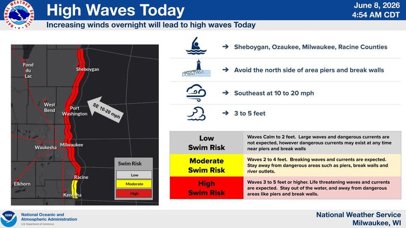
No widespread severe weather is expected in the Milwaukee area Monday, Miller said. However, one hazard to keep in mind will be dangerously high waves along the Lake Michigan shoreline. The National Weather Service issued a beach hazards statement through 7 p.m. for Milwaukee, Ozaukee, Racine and Sheboygan counties, warning people to stay out of the water due to high waves and possible rip currents.
“Those wave heights are going to be anywhere from 3 to 5 feet,” Miller said. “With the onshore waves coming in and the potential for rolling currents and currents shifting around piers and breakwaters, it will be dangerous for swimming until waves taper off this afternoon into the evening.”
As for temperatures, it’s expected to heat up in the middle of the week. Highs Tuesday, June 9, may reach the mid to upper 80s, especially further inland, and the high temperature for Wednesday, June 10, is forecast in the mid-90s – but may feel even warmer.
“With the humidity out here, the heat index values are going to be around 100 [degrees],” Miller said. “That’s borderline heat advisory criteria there, so we’ll have to keep an eye on that.”
Temps will return to the 80s Thursday and Friday, June 11-12.
Miller said there is a risk for severe thunderstorms to hit much of southeastern Wisconsin in the afternoons and evenings of Wednesday and Thursday, according to information from the National Oceanic and Atmospheric Administration’s Storm Prediction Center in Oklahoma.
“With multiple things going on this week, we just ask people to be weather aware – especially with the potential for heavy rain today in various spots, the heat midweek, and the two days of severe weather potential Wednesday and Thursday,” Miller said.
Contact Kelli Arseneau at (920) 213-3721 or karseneau@gannett.com. Follow her on X at @ArseneauKelli.
This article originally appeared on Milwaukee Journal Sentinel: Tropical-like storms, mid-90s heat expected in Milwaukee this week, NWS says
Reporting by Kelli Arseneau, Milwaukee Journal Sentinel / Milwaukee Journal Sentinel
USA TODAY Network via Reuters Connect
By Kelli Arseneau, Milwaukee Journal Sentinel | USA TODAY Network