Michigan is forecast to see a string of warm and dry days to start June, thanks to a weather pattern known as the omega block.
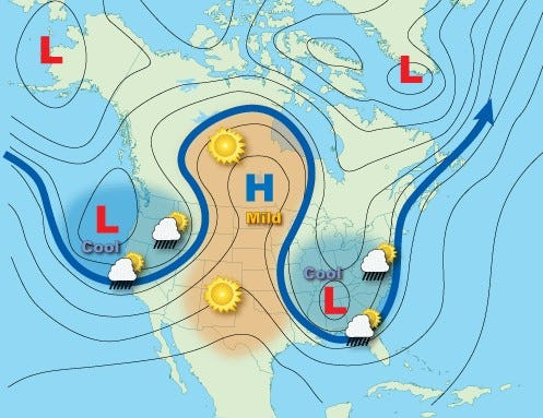
The omega block is a weather term that describes the shape of the jet stream in the northern hemisphere: a curved upside-down “U” with two outward facing lines, which appears to resemble the 24th letter in the Greek alphabet, “Ω.”

The omega shape of the jet stream is not unusual, in fact, it’s frequently observed in the late winter or early spring across the U.S., according to the National Weather Service, and is part of several basic wave patterns, particularly among blocking patterns.
“Because of their size, omega blocks are often quite persistent and can lead to flooding and drought conditions, depending upon the location under the pattern,” the National Oceanic Atmospheric Administration said. “Cooler temperatures and precipitation accompany the lows, while warm and clear conditions prevail under the high.”
For Michigan, the omega block forming now is forecast to bring warm and dry conditions for the rest of May into early June.
“Upper Michigan is now solely under the influence of a strong omega block feature per surface analysis early this morning,” Marquette NWS said on May 28. “This pattern will predominate well into next week with dry conditions and above normal temperatures.”
Michigan residents are urged to stay hydrated, to not overwork themselves, especially during the hottest hours of the day, and to check local elevated fire risks in the coming weeks via the Great Lakes Fire and Fuel map because low humidity and warm air are ideal conditions for wildfires to start.
From May 29 to June 1, summer-like air is expected across Michigan, according to the National Digital Forecast Database, with highs ranging in the 70s-80s. The warmest air is forecast on Friday, May 29, with Iron River in the southwest U.P. potentially reaching 90 degrees.
Here’s more on the omega block and how it will impact Michigan:
What is an omega block?
An omega block is a type of wave pattern with two cutoff lows and one blocking high sandwiched in between, according to the NWS and NOAA. The name comes from the shape of the jet stream, which resembles the Greek letter, omega.
A omega high is defined as, “a warm high aloft which has become displaced and is on the polarward side of the jet stream. It frequently occurs in the late winter and early spring in the northern Hemisphere.”
There are other common blocking wave patterns such as the Rex block or the blocking high.
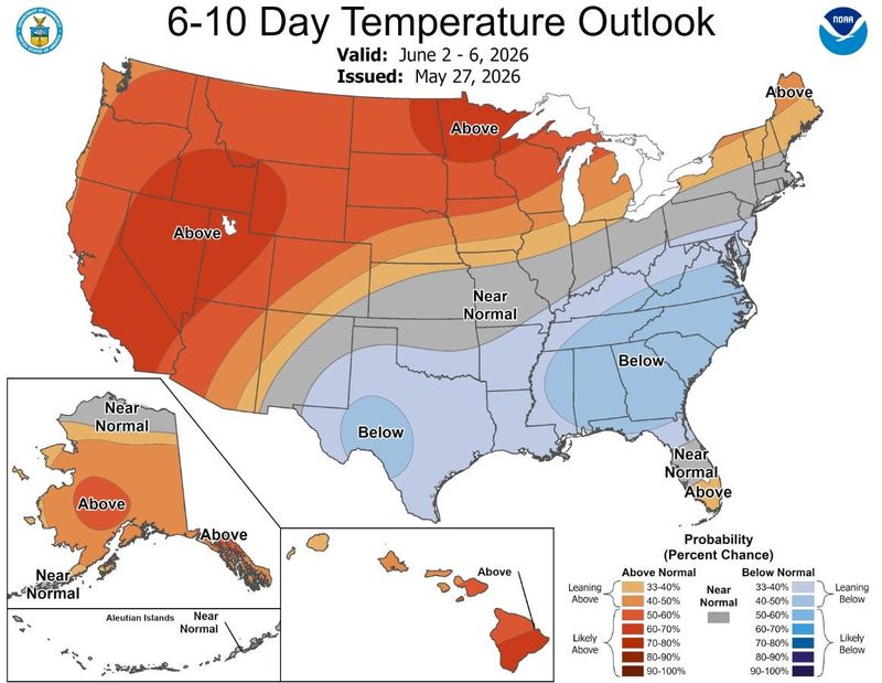
Short-range temperature outlook for U.S.
On May 27, the NWS predicts above normal temperatures across Michigan, especially in the Upper Peninsula during the first week of June.
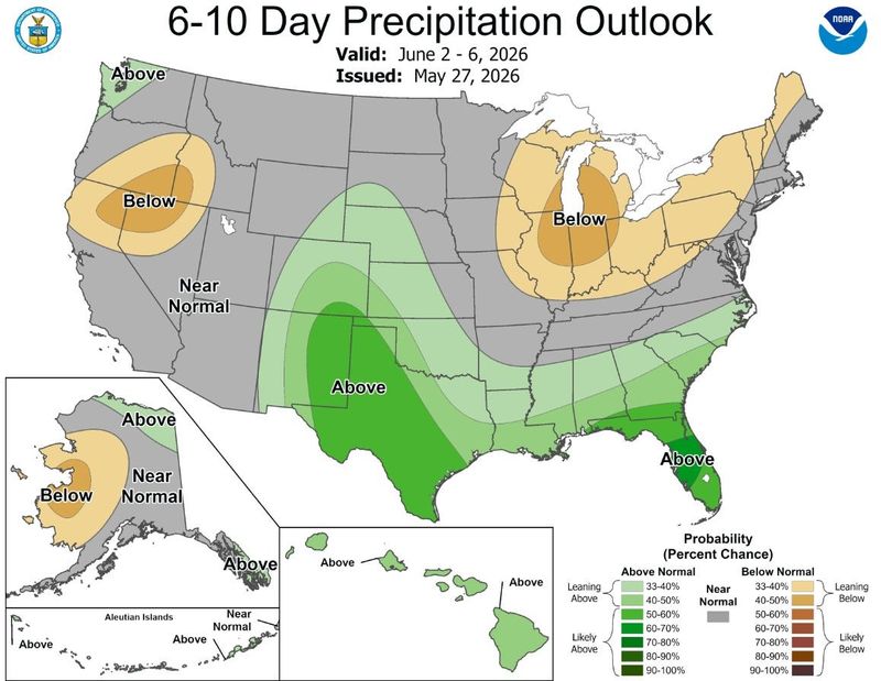
Short-range precipitation outlook for the U.S.
The NWS also issued a precipitation forecast on May 27 for early June, showing Michigan entirely under below-normal rain chances with the driest conditions in parts of the Lower Peninsula.
Contact Sarah Moore @ smoore@lsj.com
This article originally appeared on Lansing State Journal: An omega block is forming around Michigan. How it will affect weather
Reporting by Sarah Moore, USA TODAY NETWORK / Lansing State Journal
USA TODAY Network via Reuters Connect