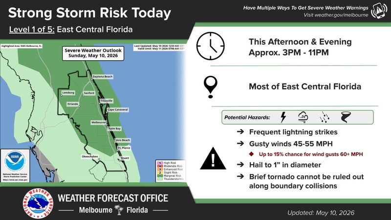
Once again, as Welcome to Rockville enters its fourth and final day, the National Weather Service in Melbourne is forecasting strong storms from 3 to 11 p.m. along the coast of Volusia County, including Daytona Beach and Daytona International Speedway.
A few of these storms could be severe, the NWS reports, with frequent lightning strikes, damaging winds, hail up to 1 inch in diameter and even a brief tornado where warmer and cooler air collide.

What’s the forecast for Welcome To Rockville in Daytona?
The Daytona Beach forecast calls for a mostly cloudy day, with a chance of showers and thunderstorms before 4 p.m., then showers likely and possibly a thunderstorm between 4 and 5 p.m., with showers and thunderstorms continuing into the evening. Concertgoers headed to Daytona International Speedway can expect a high of 87, with light northeast winds at 5 to 10 mph.
This year’s version of Welcome to Rockville has already endured two weather delays. On May 8, performances were halted for 2 1/2 hours, while on May 9, the Speedway was evacuated due to storms for 1 1/2 hours.
Tonight’s headliner, My Chemical Romance, is scheduled to take the Apex stage at 10:20 p.m.
What to do in a weather evacuation during Welcome to Rockville in Daytona Beach?
In the case of inclement weather and the need for evacuation, Welcome to Rockville organizers encourage fans to seek shelter in a few different ways.
This article originally appeared on The Daytona Beach News-Journal: Welcome to Rockville final day forecast calls for storms in Daytona
Reporting by David Wersinger, Daytona Beach News-Journal / The Daytona Beach News-Journal
USA TODAY Network via Reuters Connect