A raucous winter storm that clobbered the Northeast and Mid-Atlantic was both perilous and a “meteorological masterpiece” that hit a sweet spot for maximum snowfall over the warm Atlantic waters and cooler mainland U.S.
More than one meteorologist and weather enthusiast compared the system, dubbed Hernando by The Weather Channel, to a Category 2 hurricane based on its bombing central pressure that deepened to 966 millibars on Monday. A more typical winter storm may have a central pressure of 990 to 1000.

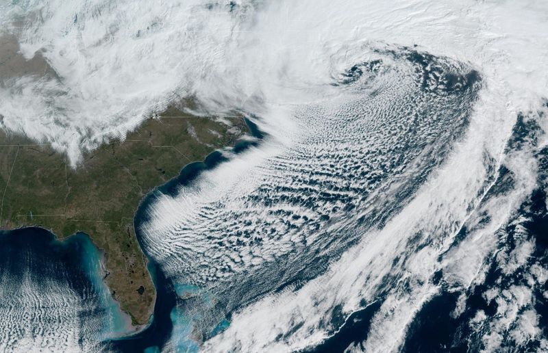
On satellite imagery, the system’s swirl of white menace resembled something more commonly seen in the tropics during the summer and early fall months of hurricane season than over the northeast in winter.
But some people took umbrage with the association of a mid-latitude cyclone to a tropical cyclone, continuing a simmering winter-long debate over how to best communicate what’s happening in the atmosphere without hype or muddling the forecast.
Can you compare a blizzard to a hurricane?
Florida meteorologist Matt Devitt was one weather expert who noted the low central pressure of this week’s nor’easter on social media and compared it to a Cat 2 hurricane. He drew special attention to a developing “eye” in the 1,200-mile-wide storm.
The post was quickly met with a biting comment noting that the storm did not have the sustained winds of a Category 2 hurricane (96-110 mph), even though what Devitt was comparing was the central pressure. He also got a request to “please stop comparing cold core storms to warm core storms. The public is confused enough.”
And, the Saffir-Simpson Hurricane Wind Scale, which ranks hurricanes in categories 1 through 5 based on sustained wind speed, stopped including central pressure as part of its measurement around 2010.
“I’m certainly not a fan of comparing winter storms to hurricanes but there is a certain similarity on the satellite, and the lay person may say it looks like a hurricane,” said AccuWeather senior meteorologist Bill Deger. “The 966 pressure is pretty incredible for a winter storm.”
Snowicane is a ‘bogus term’
It wasn’t just Hernando that drew ire from those concerned that forecasts, most notably on social media, have been mashing together meteorological phenomenon, posting single runs of a particularly provocative forecast model, and using quirky terms — snowpocalypse, snowmageddon, snowicane.
“There is no such thing as a ‘snowicane,’” said MyRadar senior meteorologist Matthew Cappucci on Facebook during this year’s early February arctic blast. “That’s a bogus term made up by clickbait, and misleading accounts trying to profit off your attention.”
Cappucci went on to explain the difference between hurricanes and winter storms.
“There are NO SIMILARITIES WHATSOEVER,” he said in the post.
In physics terms there aren’t.
Meteorologist Jeff Masters, co-founder of Weather Underground and a writer for Yale Climate Connections, said how hurricanes and winter storms are energized is one thing that sets them apart.
Why hurricanes are different from winter storms and nor’easters
Mid-latitude cyclones, which are winter storms, feed off the energy created by very strong changes in temperature, often pulling energy from the jet stream. They are considered cold core systems, are less symmetrical and don’t have a true “eye.”
Tropical cyclones, including hurricanes and tropical storms, breed in areas where there are few temperature differences and are fed by energy extracted solely from warm ocean water. They are considered warm core, stacked like a chimney and have a clear central eye where winds are calm.
Functionally, they are different also. In winter storms, the strongest winds are farther away from the center and can cover a larger area, Masters said. In hurricanes, the strongest winds swirl around the eye.
“You are not going to have the focused damage in a winter storm as you have in a hurricane,” Masters said. “I think it is a little misleading to compare the storm to a Cat 2 because the winds won’t be as strong. You need to follow up with an explanatory statement.”
By noon Monday, Hernando had deepened to 966 millibars, a monster drop of 41 millibars in 24 hours, nearly double the change it needs to denote bombogenesis.
Before pressure was removed from the Saffir-Simpson Hurricane Wind Scale, a pressure of 979 to 965 would denote a Cat 2, as referenced by Devitt in the social media post.
Hernando did include hurricane-force sustained winds near or over the warm Gulf Stream waters with gusts of up to 97 mph, according to the Ocean Prediction Center, which issued a warning to mariners.
MyRadar Weather called the nor’easter “atmospheric perfection” in a post that included a satellite image. However, it quickly explained that the center of the storm was not the same as the clear center of a hurricane.
“It is NOT an eye; it forms in completely different ways due to ‘baroclinic processes.’”
Mixed opinions about how to communicate what’s happening in the atmosphere are not new.
Weather Channel started naming winter storms
The Weather Channel began naming winter storms in 2012, similar to the practice of naming hurricanes. It caused a stir among some meteorologists because the mid-latitude cyclones carrying ice and sleet and snow can be erratic, develop unevenly, form two lows from the same trough and leave some people with a dusting of frozen precipitation and others buried in it for days.
But the practice isn’t without merit, according to the American Meteorological Society, or AMS.
“When Twitter became a force in 2011, it became clear that a hashtag would be required for each storm, so information could be filtered,” said a 2018 fact sheet published by the AMS.
Weather Channel meteorologists developed strict criteria about when a storm would earn a name based on the number of people and area covered by National Weather Service winter storm warnings.
Still, the naming practice never caught on with the NWS or other forecasting organizations such as AccuWeather, which said in 2012 that naming winter storms will create confusion “rather than delivering critical and important safety and planning information to the public.”
Masters said he was neutral when it came to naming winter storms.
“The fact that it has not caught on means maybe it should be dropped at this point, but I didn’t think it was out of bounds to try it,” he said.
As far as snowicanes, snowmageddon and snowpocalypse, he’s also less concerned.
“It’s a little hype, it’s not a technical term,” Masters said.
Kimberly Miller is a journalist for the USA TODAY NETWORK FLORIDA. She covers weather, the environment and critters as the Embracing Florida reporter. If you have news tips, please send them to kmiller@pbpost.com. You can get all of Florida’s best content directly in your inbox each weekday by signing up for the free newsletter, Florida TODAY, at palmbeachpost.com/newsletters.
This article originally appeared on Palm Beach Post: Why meteorologists debunked nor’easter’s Cat 2 ‘snowicane’ comparisons
Reporting by Kimberly Miller, USA TODAY NETWORK – Florida / Palm Beach Post
USA TODAY Network via Reuters Connect