As a large part of the South finds itself in the grips of a historic winter and ice storm, a large part of Florida, including Tallahassee, is bracing for its time in the icebox next week.
Temps will remain balmy today in the mid-70s with the chance of scattered light showers. As the winter storm encases a large section of the southeast in ice, the Big Bend and North Florida will be grappling with a marginal risk (level 1 out of 5) of severe weather.

“There is a low chance of damaging wind gusts and a brief tornado or two Sunday afternoon and evening,” the National Weather Service wrote in a post on Facebook.
Behind the cold front will be the longest cold snap so far this winter.
“Bitterly cold temperatures are expected Monday and beyond,” local National Weather Service forecasters wrote in their morning discussion. “Highs through the week will be in the 40s and 50s. Chances for a hard freeze are high (70-100%) both Monday and Tuesday nights across the entire area. Lows Monday night will be in the teens and low 20s for just about everyone except the immediate beaches.”
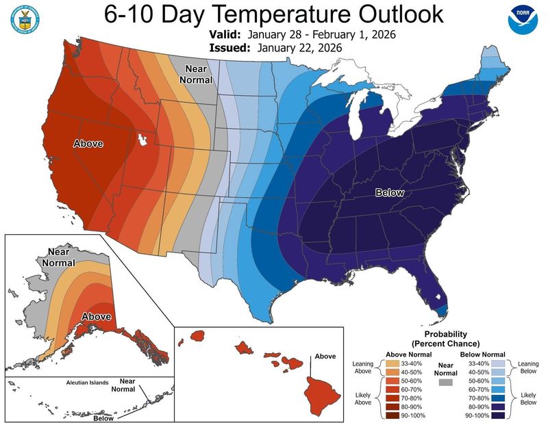
Forecasts have Tallahassee seeing below freezing temps from Monday to next Sunday, Feb. 1.
“Everyone will have wind chills well down into the teens. Cold Weather Advisories and/or Extreme Cold Watches/Warnings will likely be needed. Very little moderation is expected through the week with a medium chance of a hard freeze away from the coast each night through next week.”
Some long-range models, which are notoriously unreliable this far out, have also hinted about the possibility that Florida could see snow or its own ice storm next week.
Ryan Truchelut, the founder of Tallahassee-based WeatherTiger that does forecasting for the USA TODAY NETWORK, said “It’s too early to say with any confidence, but given the pattern, the chances are not zero” for another Florida snow or ice threat. Certainly, the temperatures will be in the right place.
“Tallahassee may well see eight or more morning lows in a row below freezing beginning Tuesday,” he wrote on Facebook. “That has only happened 12 times since 1892, most recently in 2010. The benchmark January 2010 cold outbreak had a 14-day run, #2 all-time behind 1981.”
What to know about the winter storm
While direct impacts from the immediate winter storm are almost infinitesimal for Florida, travelers to points north should be weather aware and exercise extreme caution in the days ahead. Flights will likely be canceled, especially to places bracing for impacts like Charlotte and Atlanta, which serve as hubs to Tallahassee International Airport.
The major winter storm is forecast to spread heavy snow, sleet and dangerous ice to tens of millions of Americans across two dozen states starting on Friday and continuing into the weekend.
“This is expected to be an unusually large and severe winter storm,” the National Weather Service said. “Dangerously cold air remains in the forecast for more than half of the U.S. population through the weekend and into early next week.”
The storm will start in Texas and Oklahoma with conditions worsening by Friday evening, according to forecasters. The system is then expected to spread from New Mexico to Virginia on Saturday before pushing into the Northeast on Sunday.
The weather service noted that the combination of significant snow, ice accumulations and frigid weather could cause power outages and icy roads to “linger longer than usual after a typical winter storm.” The system is forecast to bring cold temperatures not seen since 2021, according to AccuWeather.
More than 160 million people are at risk of impacts from the storm, the weather service said. Disruptive snowfall is expected from the Southern Rocky Mountains to the Northeast and areas in the South to the southern Mid-Atlantic will be hit with heavy ice.
USA TODAY contributed to this report.
This article originally appeared on Tallahassee Democrat: ‘Bitterly cold’: Tallahassee may see freezing temps all week
Reporting by Staff reports, Tallahassee Democrat / Tallahassee Democrat
USA TODAY Network via Reuters Connect