An area of disorganized weather in the Atlantic was moving northward July 20, but the chances it will develop are low, as the National Hurricane Center tracks the Atlantic basin
Conditions aren’t expected to be favorable for the stormy area to develop into something more organized, forecasters said in their Tropical Weather Outlook.

There were two other tropical waves in the Caribbean being tracked by forecasters on July 20.
➤Florida flips from watching tropics to trying to stay cool. Heat advisory issued
➤ Weather alerts via text: Sign up to get updates about current storms and weather events by location
The weather forecast for Florida on Sunday is shaping up much the same as it did Saturday. If you’re outdoors you need to protect yourself from the blazing heat. A difference is that the dangerous heat index forecast now extends farther west in the Florida Panhandle, all the way through Pensacola and beyond.
A heat advisory has been issued from the Florida Panhandle down through Central Florida. Central Florida is under an major heat risk. Heat indices are expected to climb to 110 degrees in many areas this weekend.
The next named storm of the 2025 Atlantic hurricane season will be Dexter.
Historically, the fourth named storm of the Atlantic hurricane season arrives Aug. 15. The last two named storms of the season — Barry and Chantal — developed earlier than normal.
Here’s the latest advisory from the National Hurricane Center as of 8 a.m. July 20:
NOAA Hurricane Center tracks tropical disturbance in Atlantic
A tropical wave is located about 1000 miles east-southeast of the Lesser Antilles
Environmental conditions appear only marginally conducive for development during the next day or so as the system moves northwestward around 10 mph. By the middle of the week, environmental conditions are forecast to become unfavorable for further development.
What do the colored, hatched areas on the NOAA map mean?
The hatched areas on the National Hurricane Center’s tropical outlook map indicate “areas where a tropical cyclone — which could be a tropical depression, tropical storm or hurricane — could develop,” said National Hurricane Center Deputy Director Jamie Rhome.
The colors make it visibly clear how likely a system could develop, with yellow being low, orange medium, and red high.
The National Hurricane Center generally doesn’t issue tropical advisories until there is a named storm, but there is an exception.
“If a system is near land and there is potential for development, the National Hurricane Center won’t wait before it issues advisories, even if the system hasn’t become an actual storm. This gives residents time to prepare,” Rhome said.
Florida weather radar for July 20, 2025
National Weather Service Florida forecast for July 20
➤ How to set up emergency cellphone notifications for flash flood warnings and safety tips
➤ Excessive rainfall forecast
What else is happening in the tropics?
The National Hurricane Center is tracking a tropical disturbance and a tropical wave.
AccuWeather said there’s also a potential for tropical development off the central coast of the U.S. July 22-25.
2025 hurricane season so far
An average Atlantic hurricane season has 14 named storms, seven hurricanes, and three major hurricanes.
Here’s when this year’s named storms have developed, compared to historical averages:
Heat index alert: Weather watches and warnings issued in Florida
Hurricane names for 2025 season
Here are the names for the 2025 Atlantic hurricane season, along with how to pronounce them:
When is the Atlantic hurricane season?
The Atlantic hurricane season runs from June 1 through Nov. 30.
Ninety-seven percent of tropical cyclone activity occurs during this time period, NOAA said.
The Atlantic basin includes the northern Atlantic Ocean, Caribbean Sea and Gulf of America, as the Gulf of Mexico is now known in the U.S. per an order from President Trump. NOAA and the National Hurricane Center are now using Gulf of America on its maps and in its advisories.
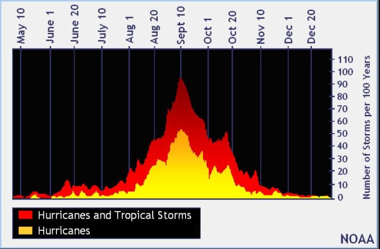
When is the peak of hurricane season?
National Hurricane Center map: See what forecasters watching now
Systems currently being monitored by the National Hurricane Center include:
Why does NHC say ‘tropical cyclone’ on its maps instead of hurricane or tropical storm?
Tropical cyclone is the generic term used by the National Weather Service, NOAA and the National Hurricane Center for any tropical system, even if it’s in the tropical Atlantic basin.
To be more precise, a tropical cyclone is a “rotating, organized system of clouds and thunderstorms that originates over tropical or subtropical waters and has closed, low-level circulation,” NOAA sadi.
Once maximum sustained winds reach 74 mph, what it is called is determined by where it originated:
Interactive map: Hurricanes, tropical storms that have passed near your city
Stay informed. Get weather alerts via text
What’s next?
We will update our tropical weather coverage daily.
Download your local site’s app to ensure you’re always connected to the news. And look for our special subscription offers here.
This article originally appeared on Palm Beach Post: National Hurricane Center watching weak disturbance. Hot weather in more of Florida
Reporting by John Gallas and Cheryl McCloud, USA TODAY NETWORK – Florida / Palm Beach Post
USA TODAY Network via Reuters Connect