PANAMA CITY — Invest 93L was moving across the state on July 15 and could have some implications for Bay County.
According to the National Hurricane Center, the system moved onto Florida’s East coast at 2 p.m. Forecasters say that when it enters the northeast Gulf on July 16, environmental conditions should be conducive for development.

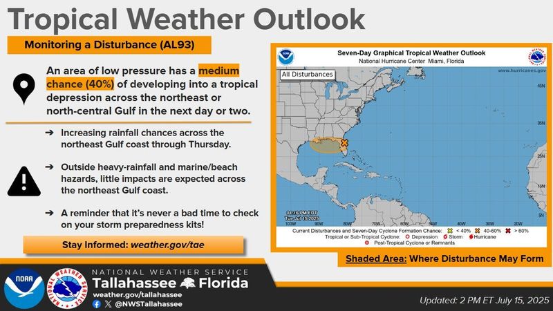
The NHC says it could form into a tropical depression. Regardless of development, they warn that it is expected to dump heavy rains and could cause flash flooding. The north-central Gulf Coast is expected to be impacted between July 16 and July 18.
“Most of these impacts will be felt in our forecast area on Wednesday and Thursday night,” said the National Weather Service’s Tallahassee forecasting office in a Facebook post. “Impacts will likely be confined to increased rain chances and elevated marine and beach hazards, such as a higher risk of rip currents, high surf, and rough seas for mariners.”
The forecasters noted that it’s never a bad time to check on your storm preparedness kits.
“Somewhat common impacts are expected across our region,” said a meteorologist in our area’s forecast discussion. “Rip currents at beaches could be a big deal on Thursday and Friday.”
“Other impacts will be fresh to possibly strong breezes on the Gulf waters, and pockets of heavy rain closer to the coast,” said the meteorologist. “Do stay weather aware through at least Thursday. A lot can change with a system such as this. Even a low-end tropical system can produce a lot of rain, and rip currents will be a big deal.”
Daily showers and thunderstorms are expected for Bay County through July 18.
State Outlook
Heavy rainfall with a risk for flash floods are predicted across portions of Florida as Invest 93L moves across the state July 15-16, according to the National Weather Service.
As is moves into the Gulf, the National Hurricane Center said it has the potential of strengthening into a tropical depression.
➤ Weather alerts via text: Sign up to get updates about current storms and weather events by location
➤ Track all active storms
Most spaghetti models on July 15 show the system moving north after it enters the Gulf, with AccuWeather forecasters predicting a possible landfall July 17 Louisiana.
The next named storm of the season will be Dexter.
Is there a tropical storm or hurricane coming toward Florida?
Satellite and radar data indicate the shower and thunderstorm activity associated with the system of low pressure located just offshore of the east coast of Florida remains disorganized, according to the 8 a.m. advisory from the National Hurricane Center.
This system is forecast to move westward across the Florida Peninsula July 15 and then reach the northeastern Gulf by Wednesday, July 16.
Environmental conditions appear generally favorable for additional development, and a tropical depression could form while the system moves across the northeastern and north-central Gulf.Regardless of development, heavy rainfall could produce localized flash flooding over portions of Florida through mid-week.
Heavy rainfall could also cause flash flooding for portions of the north-central Gulf Coast during the middle to latter portions of this week.
Spaghetti models for Invest 93L
Special note about spaghetti models: Illustrations include an array of forecast tools and models, and not all are created equal. The hurricane center uses only the top four or five highest performing models to help make its forecasts.
Florida impacts from system moving across state include heavy rain, flooding potential
National Weather Service offices around Florida warned on X it was still too early to determine specifics about the track, strength or impacts from Invest 93L and advised residents to monitor forecasts for the latest updates.
“Regardless of any further development, associated thunderstorm activity and plentiful tropical moisture will bring the threat of isolated to scattered flash flooding to Florida, with a slight risk in place for the central Peninsula Tuesday,” the National Weather Service said.
“Increasing thunderstorm chances will shift westward with the low along the central Gulf Coast Wednesday (July 16) with additional isolated instances of flash flooding possible.”
Weather alerts issued in Florida
Excessive rainfall forecast across Florida
Weather radar for Pensacola, Florida. See forecast for work week
Follow National Weather Service Mobile on X, formerly known as Twitter
Weather radar for Tallahassee, Florida. See forecast for work week
A heat advisory is in effect from 11 a.m. until 8 p.m. July 15. Heat index values around 108 are expected across portions the the Big Bend and Florida Panhandle.
Follow the National Weather Service Tallahassee on X, formerly known as Twitter
Weather radar for Jacksonville, Florida. See forecast for work week
Follow the National Weather Service Jacksonville on X, formerly known as Twitter
Weather radar for Daytona Beach, Florida. See forecast for work week
Follow the National Weather Service Melbourne on X, formerly known as Twitter
Weather radar for Melbourne, Florida. See forecast for work week
Follow the National Weather Service Melbourne on X, formerly known as Twitter
Weather radar for Port St. Lucie, Florida. See forecast for work week
Follow the National Weather Service Melbourne on X, formerly known as Twitter
Weather radar for West Palm Beach, Florida. See forecast for work week
Follow the National Weather Service Miami on X, formerly known as Twitter
Weather radar for Miami, Florida. See forecast for work week
Follow the National Weather Service Miami on X, formerly known as Twitter
Weather radar for Naples, Florida. See forecast for work week
Follow the National Weather Service Miami on X, formerly known as Twitter
Weather radar for Fort Myers, Florida. See forecast for work week
Weather radar for Sarasota, Florida. See forecast for work week
Follow the National Weather Service Tampa Bay on X, formerly known as Twitter
Weather radar for Orlando, Florida. See forecast for work week
Follow the National Weather Service Melbourne on X, formerly known as Twitter
Stay informed. Get weather alerts via text
What’s next?
We will continue to update our weather coverage as conditions warrant. Download your local site’s app to ensure you’re always connected to the news. And look for our special subscription offers here.
This article originally appeared on The News Herald: As Invest 93L crosses Florida, what impact could it have on Bay County?
Reporting by Dylan Gentile and Cheryl McCloud, Panama City News Herald / The News Herald
USA TODAY Network via Reuters Connect