The National Weather Service is predicting an outbreak of severe storms Friday in the Tri-State.
The Storm Prediction Center has placed the region in a “moderate risk” zone.

8:14 p.m.: Worst of the storms east of Evansville area
National Weather Service radar indicates that the line of storms has moved east of the city of Evansville.
8 p.m.: Warning issued for parts of Warrick, Pike and Spencer counties
Severe Thunderstorm Warning including Boonville IN, Dale IN and Lynnville IN until 8:30 PM CDT pic.twitter.com/JbkBd4ZwjA
7:54 p.m.: Severe thunderstorm warning, includes southern half of Vanderburgh County
Severe Thunderstorm Warning including Evansville IN, Henderson KY and Mount Vernon IN until 8:45 PM CDT. This storm will contain wind gusts to 70 MPH! pic.twitter.com/vVtm4ZCKW2
7:46 p.m.: Update from National Weather Service
5/16/2025 7:30 pm: Latest radar update continues to show numerous severe thunderstorms across the area! Any storm could produce large hail, damaging winds and tornadoes! Stay safe and have multiple ways to receive warnings. pic.twitter.com/33Mtq5X4cd
7:44 p.m.: Another severe thunderstorm warning issued
Severe Thunderstorm Warning including Morganfield KY, Shawneetown IL and Uniontown KY until 8:30 PM CDT. This storm will contain golf ball sized hail! pic.twitter.com/F3vanvvQj9
7:41 p.m.: Damage reported in Union County, Kentucky
A weather spotter in Union County, Kentucky, reported storm damage along Kentucky 130 near Robinson Road. Additionally, damage was reported near Ed Ricketts Road south of Morganfield. A tornado warning was in effect for the county.
7:14 p.m.: Another tornado warning as storm moves into Western Kentucky
Tornado Warning including Henderson KY, Morganfield KY and Shawneetown IL until 8:00 PM CDT pic.twitter.com/FWWvubImvz
7:03 p.m.: Tornado warning issued in Southern Illinois
Tornado Warning including Shawneetown IL, Equality IL and Old Shawneetown IL until 7:30 PM CDT pic.twitter.com/P5pAFzOvSp
6:35 p.m.: Storm warnings starting to pop up in Tri-State
Severe Thunderstorm Warning continues for Poseyville IN, New Harmony IN and Parkers Settlement IN until 7:00 PM CDT pic.twitter.com/b6MMsvzGiY
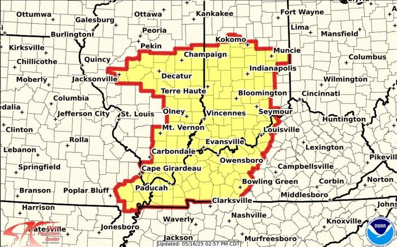
3:25 p.m.: Tornado watch issued for Tri-State
The tornado watch has been expanded to include the entire Quad State area through much of this evening. Strong tornadoes, hail to tennis ball size and hurricane wind gusts to 80 mph all possible through this evening! Have multiple ways to receive warnings!!! pic.twitter.com/5Xf1b5EwBr
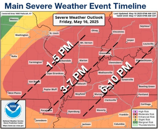
Noon: Hurricane-force winds, baseball-sized hail, and significant tornadoes possible this evening
The National Weather Service provided a grim update on Friday’s chances for severe weather.
According to a bulletin sent around noon, the Evansville area could see hurricane-force winds, up to baseball-sized hail, and the potential for EF2-or-greater tornadoes.
NWS marked their confidence in the chance of storms as “high.” The only remaining uncertainty is when they may arrive. The bulletin had storms sweeping into the Evansville area sometime between 3 p.m. and 7 p.m.
“Storms may initially form as individual supercells that would pose a higher risk for strong tornadoes (EF2+) and very large hail (up to baseball size),” the bulletin reads. “The storms would likely form into a single line of storms posing a higher risk for hurricane force winds and tornadoes.”
Severe weather is expected all across the Tri-State. Meteorologists stressed that residents should have plans in place for adequate shelter and the possibility of power outages and tree damage.
11 a.m.: Slight change to storm timing
10:28 a.m.: Warrick County schools announce cancellations, postponements
From a Warrick County School Corporation Facebook post:
Due to the prediction for potential severe weather this evening, all WCSC after school activities and programs have been cancelled. Tecumseh High School graduation has been rescheduled for tomorrow evening, May 17 at 7 p.m. More information will be sent to parents and students from Castle High School regarding the Senior Awards Night.
9:30 a.m.: EVSC ending afterschool programs early
The Evansville Vanderburgh School Corp. announced Friday morning all after school programs would end no later than 4:30 p.m. due to potential severe weather.
Evansville weather radar
Reporting power outages in the Tri-State
Depending on the service in your area, you can check the latest status of your power outage, how widespread the outage is, an estimated restoration time and more.
Here are the services offered by the larger providers in the Tri-State, and links for each power outage map.
CenterPoint power outage map
Customers with CenterPoint Energy can find their current power outages here.
Duke Energy power outage map
Duke Energy customers can find a map of power outages here. To report an electrical outage, click here or call 800-343-3525.
Duke’s map also has the ability to show outage histories and a current summary of known issues and how many customers are impacted.
Kenergy power outage map
Kenergy customers in Western Kentucky can find a map of power outages here. To report an electrical outage, call 800-844-4832.
This article originally appeared on Evansville Courier & Press: UPDATES: Tornado watch issued for the Tri-State
Reporting by Sarah Loesch, Jon Webb, Houston Harwood, MaCabe Brown, Ryan Reynolds and Thomas B. Langhorne, Evansville Courier & Press / Evansville Courier & Press
USA TODAY Network via Reuters Connect