Severe weather pushes through Leon County
As the squall line pushes out of Leon County, a severe thunderstorm warning has been issued for parts of Wakulla, Jefferson, Taylor and Madison counties. Only about 100 customers were out of power in Tallahassee, according to the city’s outage map. Talquin took a harder blow with 1,000 customers in the dark in the Chaires area and about 300 out in Bristol.

In Bradfordville, a tree was reported down on house. In Killearn Estates, residents reported a tree down near the intersection of Pimlico Drive and Jamaica Court. Meanwhile, parts of Tram Road were covered in branches with about 4 trees down near and west of the intersection of Tram Road and Saint Joe Road.
At 4:20 p.m., the rumble of thunder could still be heard and rain was likely to continue in Tallahassee till about 5 p.m. The severe thunderstorm watch remains until 6 p.m.
50 mph wind gust recorded at FSU
At about 3:35 p.m., the National Weather Service Office in Tallahassee, based at FSU, recorded a 50 mph wind gust as the squall line began pushing through the capital city region.
Leon County Schools to delay middle school dismissal
Middle Schoolers in Leon County Schools will be held 30 minutes later than usual and dismissed at 4:30 p.m., district spokesperson Chris Petley said after the National Weather Service issued a severe thunderstorm warning for the Big Bend region, including Leon County.
Afterschool activities will continue as planned unless otherwise decided by school site administrators.
Leon County under severe thunderstorm warning
The National Weather Service in Tallahassee has issued a severe thunderstorm warning for Leon and several other Big Bend counties.
Winds up to 60 mph and pea-sized hail was possible within the warning area.
Severe Thunderstorm Warning including Tallahassee FL, Thomasville GA and Bainbridge GA until 4:00 PM EDT pic.twitter.com/madx8NpfZs
The warning is in effect until 4 p.m. eastern for northwestern Gulf County, southeastern Calhoun County, Wakulla County, Gadsden County, Liberty County and Leon County in Florida and southeastern Decatur County, Grady County and southwestern Thomas County in Georgia.
FSU Alert, the emergency warning system of Florida State University, told students: “Stay inside. If caught outside, take shelter in a sturdy enclosed building or hard top automobile immediately. Avoid open spaces, isolated objects.”
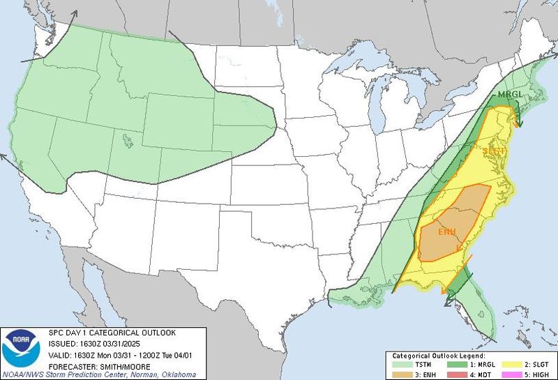
Severe weather threat downgraded a notch for North Florida
The Storm Prediction Center downgraded the severe weather threat for North Florida from enhanced (level 3 of 5) to slight (level 2 of 5).
Damaging wind gusts, tornadoes and hail are still possible, the National Weather Service/Tallahassee said in an afternoon social media post.
The move comes as a severe thunderstorm warning went up from Santa Rosa Beach and Panama City Beach north through Marianna and past the state line into Georgia. The warning states the area could see 60 mph winds and pea-sized hail.
Severe Thunderstorm Warning including Panama City FL, Lynn Haven FL and Callaway FL until 1:00 PM CDT pic.twitter.com/WeiJG0MIkr
Leon County Schools could briefly hold students during severe weather
While a neighboring school district opted for early dismissal, Leon County Schools could hold students from leaving school if severe weather conditions ramp up during dismissal times.
“This afternoon, there is an increased risk of isolated severe thunderstorms associated with a fast-moving weather system. If necessary, LCS will temporarily hold dismissal of our schools if the severe weather arrives during that time,” the district’s message said.
That contingency plan would include students who are bus riders, car riders and walkers.
If there is a delay, parents who are in the car line waiting to pick-up students at the school are asked to wait in there cars.
All afterschool activities will continue as normal.
Leon and surrounding counties under severe thunderstorm watch
The National Weather Service in Tallahassee issued a severe thunderstorm watch for parts of Alabama, Florida and Georgia.
The watch, which includes Leon and a number of other counties in the Florida Panhandle and Big Bend, is in effect until 6 p.m.
A severe thunderstorm watch has been issued for parts of Alabama, Florida and Georgia until 6 PM EDT pic.twitter.com/fsRkfJNGZd
Threats to the forecast area include a couple of tornadoes, up to quarter-sized hail and scattered gusts up to 65 mph.
Jefferson County Schools announces early dismissal ahead of storms
The Jefferson County School District announced Monday morning its K-12 school site will release students early at 2 p.m. due to the impending severe weather threat. All afterschool programs have also been cancelled.
Leon County schools not anticipating early closure from storms
Leon County Schools said in a Facebook post that it is continuing to monitor a severe storm system expected to arrive sometime this afternoon in Tallahassee.
“Our leadership team is monitoring an incoming weather system estimated to arrive in our area this afternoon,” the district said. “We will continue to learn more about the forecast this morning and provide an update about school dismissals to our school community through FOCUS around noon today. At this time, we do not anticipate an early dismissal of our schools.”
Squall line could bring 60 mph gusts to Tallahassee
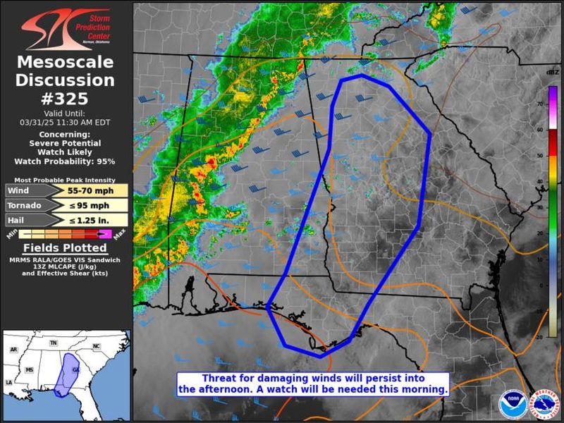
Forecasters with the Storm Prediction Center expect severe weather watches to be issued later today as a strong squall line sweeps across the region.
The SPC said there was a 95% watch probability for a broad area that includes a chunk of the Big Bend and Panhandle. Forecasters with with SPC did not specify whether the watch would be for severe thunderstorms or tornadoes.
Wright Dobbs, meteorologist with the National Weather Service in Tallahassee, said the line is still expected to arrive in the capital city between 3 and 6 p.m.
“Tornado probabilities since 24 hours ago have gone down a little bit, and at least right now, with the line coming through, the main concerns are going to be that potential for damaging wind gusts,” he said.
Dobbs said wind gusts could top out around 60 mph and that higher winds capable of causing widespread destruction were not expected. He added that while the risk of tornadoes had gone down, it was not zero.
“We can’t rule out a tornado or two in the line when it moves through,” he said. “Also, if we see storms form out ahead of the line, it’s possible a tornado could be in those if they get strong enough. They’d have to be pretty strong ahead of the line for that to happen.”
Sunday update
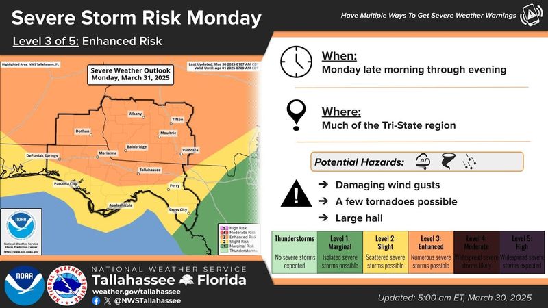
Forecasters say we’re in for a rough start to the week, with rising risks of severe weather that could include damaging wind gusts, large hail, and even the chance of a few tornadoes.
On Sunday, the National Weather Service in Tallahassee upgraded Florida’s capital city and areas along the I-10 corridor and north of it to a Level 3 of 5 enhanced risk for severe storms on Monday.
“Increases in the tornado (10-14%) and damaging winds (30-44%) probabilities largely drove the risk up,” forecasters wrote in their Sunday morning discussion.
The worst weather could arrive between 3 p.m. and 6 p.m.
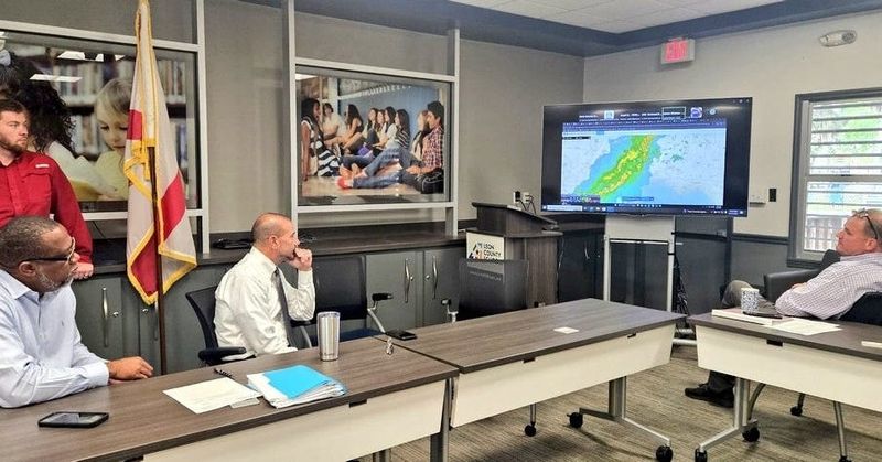
The Leon County School District is monitoring the situation.
“The National Weather Service is forecasting possible severe storms in our area late tomorrow morning and early afternoon,” the district wrote on Facebook Sunday afternoon. “As of now, there are NO CHANGES to school operations. Staff will monitor the forecast during the morning and alert you by midday if there are any changes to dismissal times.”
The storm threat kicks off late Monday morning and could stick around through the evening. Residents in Tallahassee, Marianna, Bainbridge, Valdosta, and nearby areas should have a way to get alerts — whether it’s a weather radio, phone notifications, or local news updates.
The storms could bring the potential for power outages, downed trees, and dangerous driving conditions.
The main threat will come with “an organized squall line” though “discrete storms out ahead of the main line will also be capable of producing tornadoes and/or hail, especially if they become supercellular.”
Forecasters say the storm system will be fueled by favorable atmospheric conditions and a daytime passage that will enable the system to take advantage of the heat of the day. Still, they noted preceding convection or thick cloud cover could create a “failure mode.”
The storm will usher in a weak cold front early next week, to be replaced by above-normal temperatures with highs in the mid-to-upper 80s.
This article originally appeared on Tallahassee Democrat: Tallahassee area under severe thunderstorm warning; 60 mph winds, pea-sized hail possible
Reporting by William L. Hatfield, Jeff Burlew and Alaijah Brown, Tallahassee Democrat / Tallahassee Democrat
USA TODAY Network via Reuters Connect