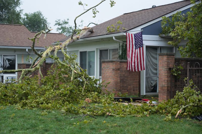
The ominous dark skies mid-morning Aug. 11 foretold the fury of the approaching storm: hurricane-force wind gusts, thunder that shook buildings, lightning flashing like strobes, and trees falling down. And the unrelenting pelting of cars and homes with torrential rains that would eventually overwhelm gutters and drains and flood roadways.
By the week’s end, tens of thousands in greater Columbus still had no power. Food had spoiled. Basements flooded. Outdoor plans were doused. Tarps covered gaping holes in some homes.

Some experts called it the worst storm system in more than a decade.
But the derecho winds and a confirmed tornado on Columbus’ South Side that downed power poles and lines and flooding could have been so much worse.
Four inches of rain in parts of the state, for example, would translate into four feet of snow had it been winter, a story left to tell in future months.
While the two days of damaging winds and rain Aug. 10-11 struck areas of Columbus’ Clintonville, University District, Olde Towne East, Linden, East Side and South Side as well as Bexley, Dublin, Hilliard, and Upper Arlington hard, others, including Westerville, Worthington and much of Delaware County, were largely unscathed.
And it was only just March 15 when about 50,000 Franklin County residents lost power, many for several days, following a similar storm front when powerful straight-line wind strafed the region. American Electric Power Ohio officials had called that the worst damage to the electrical grid in more than a decade, lessened, possibly, by a lack of tree leaves to act as sails to down limbs.
Yes, this year’s storms were bad. But there have been far worse.
Derecho sets new benchmark
It was 2012, when “derecho” became a household name. And just months later, remnants of superstorm Sandy.
The massive windstorm that swept from Chicago through the Ohio Valley and eastern U.S. on June 29, 2012, left five million people without electrical power; more than 600,000 customers in Ohio alone. Weather stations saw wind speed records set along the way.
The derecho was followed by severe thunderstorms two days later and a string of 90-degree days amid a record-setting heat wave where high temperatures reached 100 degrees on Independence Day.
Miserable. And to many, unforgettable.
Then Sandy arrived, on Oct. 30, 2012, a superstorm that battered the East Coast, with storm bands raking much of northern Ohio. The town of Brunswick near Cleveland cancelled Beggar’s Night, hosting a “Frankenstorm” party instead. Central Ohio clocked gale-force winds (39 to 54 mph) followed by rain and snow.
The Midwest is supposed to be immune from hurricanes, at least from direct hits.
But it was remnants of Hurricane Ike, a Category 4 storm in September 2006, when a peak of 425,000 homes and businesses in central Ohio were without electricity. The storm closed schools and opened emergency shelters. Trees were scattered. Homes were battered.
There have been others to rival the calamity of the past week.
The tornado debate
The National Weather Service on Aug. 12 reported there was no radar indication of a tornado in the mass of the storm that was passing over Columbus and central Ohio after forming in the Chicago area and tearing through Illinois and Indiana on the way here. That’s why they didn’t issue a tornado warning for Franklin County and why the county Emergency Management and Homeland Security Agency did not set off sirens, despite winds of more than 80 mph recorded at John Glenn Columbus International Airport at about 10:40 a.m. Aug. 11.
However, following a National Weather Service field survey, the agency concluded there was a tornado that struck Columbus’ South Side. Besides damaging numerous businesses and homes, it knocked over a long row of power poles on the east side of Interstate 71 next to Berliner Park and caused extensive damage to the park.
“Tornado or not, severe thunderstorms could produce equivalent results. It’s still damaging and people are affected by it,” said Kristen Cassady, science and operations officer at the National Weather Service.
And despite sunny, mostly cloudless skies Aug. 13, more foul weather is forecast.
“We are just in one of these patterns. It doesn’t look it’s going to break until early next week,” said Cassady, who’s worked at the service for more than a decade.
Riding the storm out
Meteorologists have cool names for lots of weather: bomb cyclones, polar vortex in the winter; heat domes and atmospheric rivers in summer.
A “ridge rider” best describes the week’s powerful thunderstorm pattern, which tracks along the outer periphery of a strong high-pressure heat dome.
“This type of pattern puts us on the northern fringe of a hot and humid air mass,” said Cassady. “And the further north you get from that, you get an overlap that creates an unstable environment and multiple rounds of thunderstorms day after day after day.
Cassady’s job is to educate the public and encourage safety through forecasting. Questions about man-made climate change causing drought, forest fires and other extreme events are not.
“Each event is slightly different for any one person,” she said. “But certainly duringTuesday’s [Aug. 11] storms we were all about focusing on the warnings, she said of her staff in Wilmington, about 90 minutes southwest of Columbus.
Cassady noted that 2024 set a record for tornadoes in Ohio. But since then, counts have returned to normal.
“These patterns come around every so often,” she said. “It’s difficult for us to determine if there’s a trend. My expertise is making sure the message is getting out.”
State Climatologist Aaron Wilson, an assistant professor at Ohio State University, does connect extreme weather to climate change.
“It is complex,” Wilson said. However, he noted that waves of heat and cold are easier to attribute to man-made conditions than hail, tornadoes or isolated events. The science requires looking at both models, observing real-world conditions and studying inflation-adjusted insurance losses after storms.
“The duration and magnitude of heat waves is increasing in the United States,” he said. “The current ongoing heat wave in Europe has a greater percent likelihood of occurring than it has in the past. The heat and cold events are more likely than they were in the past.
“Droughts and extreme rainfall are extreme events. And we have been able to attribute them to more extreme amounts of moisture in our atmosphere,” he said.
Wilson acknowledged that “people are feeling fatigued by these extreme weather events. But our projections continue to show that these extreme events are going to continue into the future,” Wilson said. “It’s something that affects us all. “
Aug. 14 is forecast to be mostly cloudy with potential for thunderstorms throughout the day. Highs will be in the low 80s with a 70% chance of rain. Some storms could produce heavy downpours, according to the NWS. A lesser chance of rain (30%) is forecast for Aug. 15 and 16.
Growth and development reporter Dean Narciso can be reached at dnarciso@dispatch.com.
This article originally appeared on The Columbus Dispatch: Ohio’s 2012 derecho dwarfs Columbus’ latest storm in scale, damage
Reporting by Dean Narciso, Columbus Dispatch / The Columbus Dispatch
USA TODAY Network via Reuters Connect
By Dean Narciso, Columbus Dispatch | USA TODAY Network