Indianapolis and Central Indiana have been flanked by days of thunderstorms and endless rain. Now, that stormwater is compounding, resulting in significant flooding, wiped-away roads and closed flood gates.
Five people have died from flooding across the state. Dozens of others have been rescued from flooded areas near the White River, including in the Rocky Ripple, Ravenswood and Broad Ripple neighborhoods. At least 400 have been evacuated in Ravenswood in addition to those evacuated from Broad Ripple on Friday night, Indianapolis public safety officials said at a Saturday news conference. At least 40 people have been evacuated in Carmel, including residents of an assisted living facility.

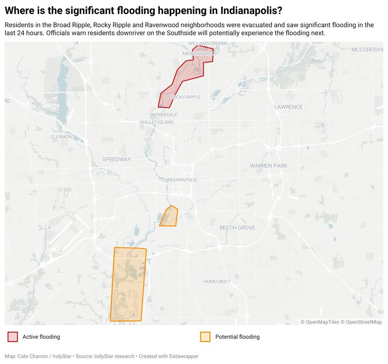
Officials expect several neighborhoods along the White River on the south side of Indianapolis to potentially experience flooding next.
Check our live blog for minute-by-minute coverage.
Broad Ripple, Rocky Ripple and Ravenswood
Residents in the Broad Ripple, Rocky Ripple and Ravenswood neighborhoods were evacuated and saw significant flooding in the last 24 hours. Public safety officials are continuing to warn residents to seek safe shelter as resources are overextended and rain continues to fall.
South side along the White River
Officials say southside residents living in these areas should be alert and are to be at risk of flooding. Neighborhoods include:
Noblesville and Hamilton County
In Noblesville, Mayor Chris Jenson called the flooding “absolutely historic,” and, as of 6:30 p.m. on Aug. 15, Hamilton County remained under a state of emergency because more than 60 roads were closed due to severe flooding.
Noblesville’s river level is starting to come down after it crested at 24.6 feet overnight on Friday. The descent is expected to slow since rain is currently active. Last week, the river was measured at just under 4 feet.
Hamilton County Commissioners declared a state of emergency Friday morning as steady rainfall continued to worsen flooding conditions in the area, leading to road closures and water rescues.
Anderson, Muncie, New Castle
The White River, which carves through Anderson from east to west, was measured at 24.93 feet early Friday, Aug. 15 – the highest it’s been documented in the town since the United States Geological Survey started keeping records.
New Castle, a town northeast of Indianapolis, was hit particularly hard, with a bridge collapse and numerous water rescues.
Jeff Stanley, chief deputy of the Delaware County Sheriff’s Department, said a 59-year-old woman was found dead in a cornfield southwest of Muncie. Investigators believe the woman was trying to “travel through moving water covering the roadway when her vehicle was swept from the road by the strong current.”
The USA TODAY Network – Indiana’s coverage of First Amendment issues is funded through a collaboration between the Freedom Forum and Journalism Funding Partners. All coverage is paywall-free.
Have a story to tell, tip or question? Reach Cate Charron by email at ccharron@indystar.com, on X at @CateCharron or Signal at @cate.charron.28.
This article originally appeared on Indianapolis Star: Where is the flooding in Indianapolis? Check our maps
Reporting by Cate Charron, Indianapolis Star / Indianapolis Star
USA TODAY Network via Reuters Connect
By Cate Charron, Indianapolis Star | USA TODAY Network